File:Virginiacolony.png
Size of this preview: 574 × 600 pixels. Other resolutions: 230 × 240 pixels | 600 × 627 pixels.
Original file (600 × 627 pixels, file size: 291 KB, MIME type: image/png)
Captions
Captions
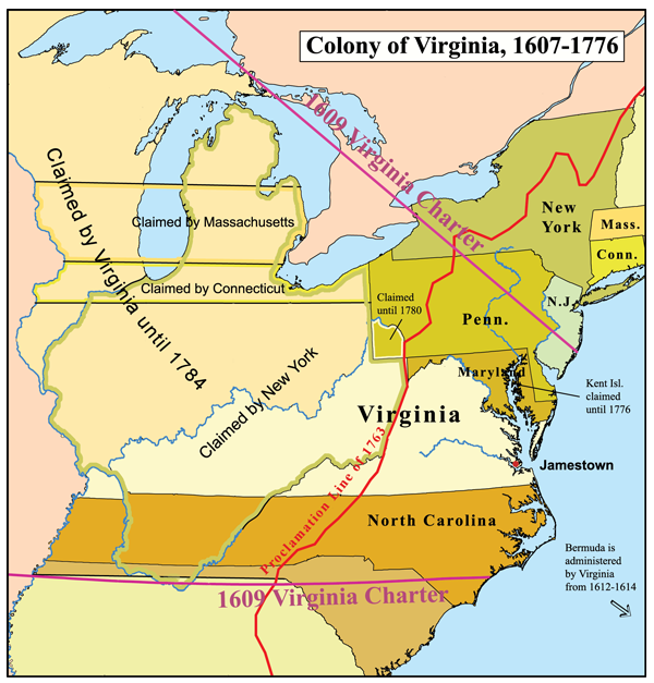
Colony of Virginia

|
This historical map image could be re-created using vector graphics as an SVG file. This has several advantages; see Commons:Media for cleanup for more information. If an SVG form of this image is available, please upload it and afterwards replace this template with
{{vector version available|new image name}}.
It is recommended to name the SVG file “Virginiacolony.svg”—then the template Vector version available (or Vva) does not need the new image name parameter. |
Summary
edit
English: Map of the Colony of Virginia — during 17th and early 18th centuries.
- Boundary disputes between colonies not involving Virginia are not shown.
Licensing
edit
I, the copyright holder of this work, hereby publish it under the following license:
This file is licensed under the Creative Commons Attribution-Share Alike 2.5 Generic license.
- You are free:
- to share – to copy, distribute and transmit the work
- to remix – to adapt the work
- Under the following conditions:
- attribution – You must give appropriate credit, provide a link to the license, and indicate if changes were made. You may do so in any reasonable manner, but not in any way that suggests the licensor endorses you or your use.
- share alike – If you remix, transform, or build upon the material, you must distribute your contributions under the same or compatible license as the original.
File history
Click on a date/time to view the file as it appeared at that time.
| Date/Time | Thumbnail | Dimensions | User | Comment | |
|---|---|---|---|---|---|
| current | 21:58, 8 December 2006 | | 600 × 627 (291 KB) | Kmusser (talk | contribs) | |
| 16:08, 16 November 2006 |  | 600 × 627 (220 KB) | Kmusser (talk | contribs) | This is a map of the Colony of Virginia that I made. Boundary disputes between colonies not involving Virginia are not shown. == Licensing == {{self|cc-by-sa-2.5}} Category:Maps of disputed territories [[Cate |
You cannot overwrite this file.
File usage on Commons
The following 2 pages use this file:
File usage on other wikis
The following other wikis use this file:
- Usage on ar.wikipedia.org
- Usage on ca.wikipedia.org
- Usage on da.wikipedia.org
- Usage on de.wikipedia.org
- Usage on en.wikipedia.org
- Colony of Virginia
- Charles Lynch (judge)
- William Claiborne
- List of former counties, cities, and towns of Virginia
- Edward Maria Wingfield
- User:Kmusser/Images
- Wikipedia:Featured article candidates/Cuisine of the Thirteen Colonies/archive1
- Wikipedia:Featured article candidates/Archived nominations/July 2009
- Territorial evolution of North America prior to 1763
- User:TBP25/sandbox/Surveying In North America
- Surveying in North America
- Usage on eo.wikipedia.org
- Usage on es.wikipedia.org
- Usage on fa.wikipedia.org
- Usage on fi.wikipedia.org
- Usage on fr.wikipedia.org
- Usage on he.wikipedia.org
- Usage on hy.wikipedia.org
- Usage on id.wikipedia.org
- Usage on it.wikipedia.org
- Usage on ja.wikipedia.org
- Usage on la.wikipedia.org
- Usage on lt.wikipedia.org
- Usage on nl.wikipedia.org
- Usage on no.wikipedia.org
- Usage on oc.wikipedia.org
- Usage on pl.wikipedia.org
- Usage on ro.wikipedia.org
- Usage on ru.wikipedia.org
- Usage on sh.wikipedia.org
- Usage on simple.wikipedia.org
- Usage on sv.wikipedia.org
- Usage on tr.wikipedia.org
- Usage on uk.wikipedia.org
- Usage on vi.wikipedia.org
- Usage on www.wikidata.org
- Usage on zh.wikipedia.org