File:VkDE-bd 1890.svg

Size of this PNG preview of this SVG file: 420 × 600 pixels. Other resolutions: 168 × 240 pixels | 336 × 480 pixels | 538 × 768 pixels | 717 × 1,024 pixels | 1,435 × 2,048 pixels | 1,261 × 1,800 pixels.
Original file (SVG file, nominally 1,261 × 1,800 pixels, file size: 249 KB)
Captions
Captions
Add a one-line explanation of what this file represents
| Description |
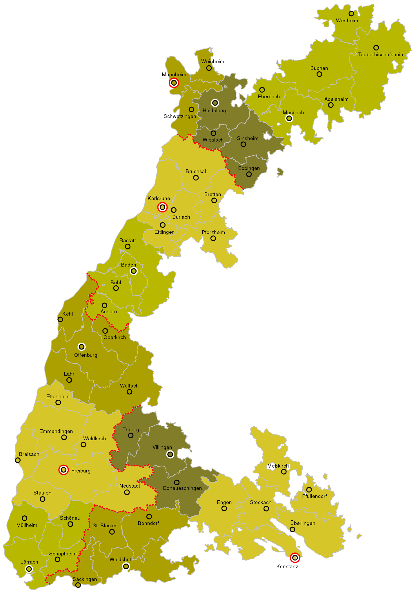
Deutsch: de:Baden, Karte der Verwaltungsgliederung (Bezirksämter, Kreise, Landeskommissärbezirke), Stand 1890
English: en:Baden, administrative map as of 1890
|
| Date | |
| Source |
Own work |
| Author | Franzpaul |
I, the copyright holder of this work, hereby publish it under the following licenses:
This file is licensed under the Creative Commons Attribution-Share Alike 3.0 Unported license.
- You are free:
- to share – to copy, distribute and transmit the work
- to remix – to adapt the work
- Under the following conditions:
- attribution – You must give appropriate credit, provide a link to the license, and indicate if changes were made. You may do so in any reasonable manner, but not in any way that suggests the licensor endorses you or your use.
- share alike – If you remix, transform, or build upon the material, you must distribute your contributions under the same or compatible license as the original.

|
Permission is granted to copy, distribute and/or modify this document under the terms of the GNU Free Documentation License, Version 1.2 or any later version published by the Free Software Foundation; with no Invariant Sections, no Front-Cover Texts, and no Back-Cover Texts. A copy of the license is included in the section entitled GNU Free Documentation License. |
You may select the license of your choice.

W3C-validity not checked.
File history
Click on a date/time to view the file as it appeared at that time.
| Date/Time | Thumbnail | Dimensions | User | Comment | |
|---|---|---|---|---|---|
| current | 20:13, 9 February 2017 | | 1,261 × 1,800 (249 KB) | Fünffingerfaultier (talk | contribs) | svg cleanup |
| 15:30, 2 September 2009 |  | 1,261 × 1,800 (249 KB) | Franzpaul (talk | contribs) | {{Information |Description= {{de|de:Baden, Karte der Verwaltungsgliederung (Bezirksämter, Kreise, Landeskommissärbezirke), Stand 1890}} {{en|en:Baden, administrative map as of 1890}} * nominal scale: 1:500,000 |Source={{Own}}<br/> design simil |
You cannot overwrite this file.
File usage on Commons
There are no pages that use this file.
File usage on other wikis
The following other wikis use this file:
- Usage on als.wikipedia.org
- Usage on de.wikipedia.org
- Verwaltungsgliederung Badens
- Bezirksamt Meßkirch
- Bezirksamt Eppingen
- Bezirksamt Sinsheim
- Bezirksamt Bretten
- Bezirksamt Bruchsal
- Bezirksamt Eberbach
- Bezirksamt Mosbach
- Kreis (Baden)
- Bezirksamt (Baden)
- Bezirksamt Durlach
- Bezirksamt Ettlingen
- Bezirksamt Pfullendorf
- Bezirksamt Engen
- Bezirksamt Donaueschingen
- Bezirksamt Baden-Baden
- Bezirksamt Schopfheim
- Benutzer:Zieglhar/Bezirksamt Säckingen
- Bezirksamt Krautheim
- Bezirksamt Achern
- Bezirksamt Oberkirch
- Bezirksamt Schönau
- Bezirksamt Triberg
- Benutzer:Zieglhar/Kreis (Baden) Ergänzung
- Bezirksamt Adelsheim
- Bezirksamt Schwetzingen
- Bezirksamt Heidelberg
- Bezirksamt Wiesloch
- Bezirksamt Weinheim
- Bezirksamt Mannheim
- Bezirksamt Karlsruhe
- Bezirksamt Pforzheim
- Bezirksamt Offenburg
- Bezirksamt Wolfach
- Bezirksamt Neustadt (Baden)
- Usage on fr.wikipedia.org
- Usage on www.wikidata.org