File:Vodmat avoiding line-ma.svg

Size of this PNG preview of this SVG file: 627 × 599 pixels. Other resolutions: 251 × 240 pixels | 502 × 480 pixels | 803 × 768 pixels | 1,071 × 1,024 pixels | 2,142 × 2,048 pixels | 1,066 × 1,019 pixels.
Original file (SVG file, nominally 1,066 × 1,019 pixels, file size: 1.74 MB)
Captions
Captions
Add a one-line explanation of what this file represents
Summary
edit
| Description |
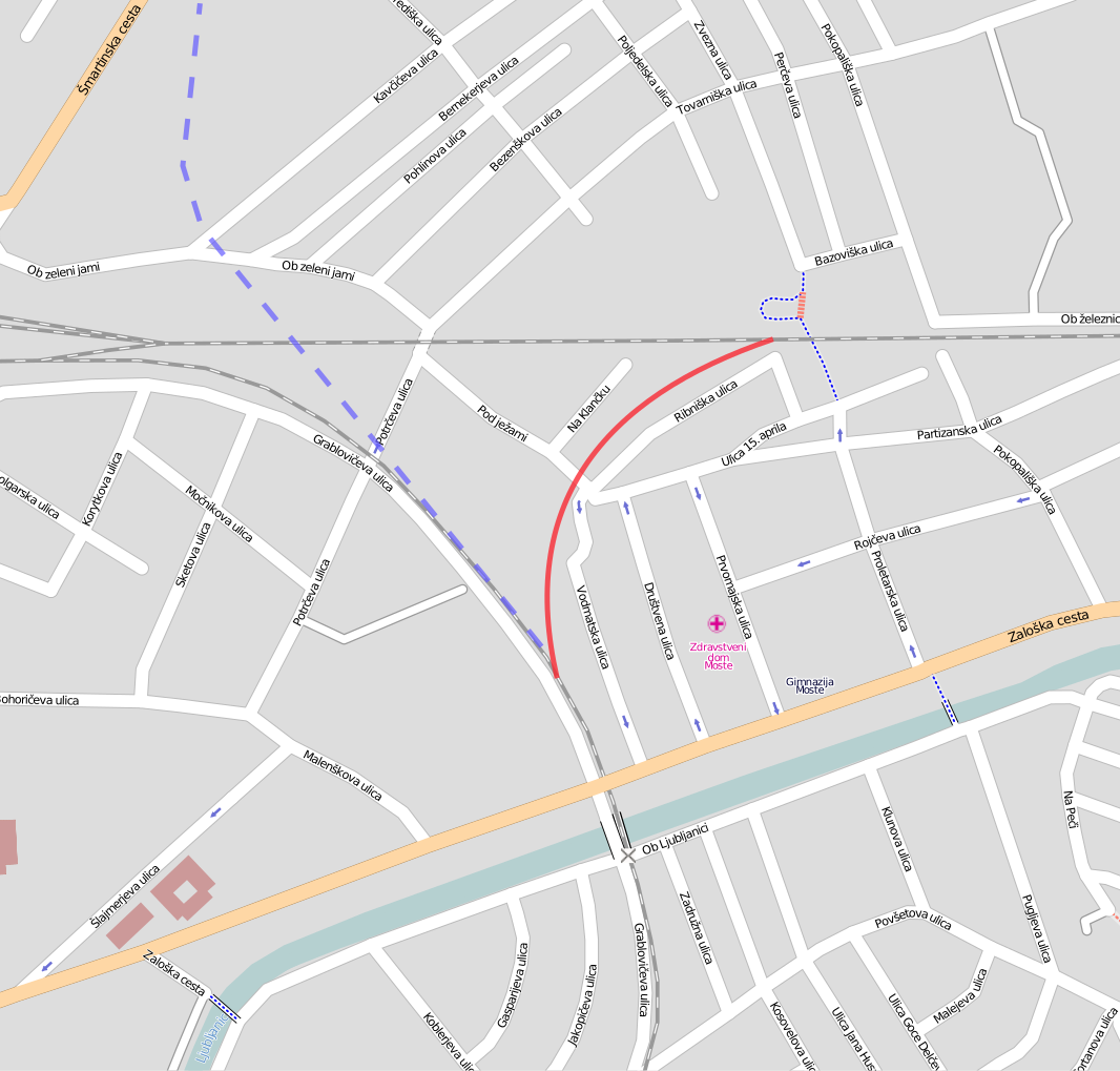
English: Vodmat rail avoiding line in Ljubljana during WW1 and from 1945 to sixties.
Original map from OpenStreetMap and additionally added the former avoiding line (in red). part of another former avoiding line from Vodmat to Dravlje is displayed by a dashed blue line.
Slovenščina: Vodmatski železniški lok (rdeča črta; obstajal je med 1. svetovno vojno ter od leta 1945 do šestdesetih let) na zemljevidu, snetem z OpenStreetMap. Črtkana modra črta prikazuje del še ene obvozne proge med Vodmatom in Dravljami |
| Date | |
| Source | Open Street Map (http://www.openstreetmap.org/?lat=46.05686&lon=14.52936&zoom=16&layers=B000FTFT) |
| Author | Ajznponar |
License: CC-BY-SA 2.0 (as applies for maps from OpenStreetMap)
Licensing
edit
This file is licensed under the Creative Commons Attribution-Share Alike 2.0 Generic license.
- You are free:
- to share – to copy, distribute and transmit the work
- to remix – to adapt the work
- Under the following conditions:
- attribution – You must give appropriate credit, provide a link to the license, and indicate if changes were made. You may do so in any reasonable manner, but not in any way that suggests the licensor endorses you or your use.
- share alike – If you remix, transform, or build upon the material, you must distribute your contributions under the same or compatible license as the original.
File history
Click on a date/time to view the file as it appeared at that time.
| Date/Time | Thumbnail | Dimensions | User | Comment | |
|---|---|---|---|---|---|
| current | 16:00, 24 July 2009 | | 1,066 × 1,019 (1.74 MB) | Ajznponar (talk | contribs) | added another former line from Vodmat to Dravlje |
| 07:03, 24 July 2009 |  | 1,066 × 1,019 (1.74 MB) | Ajznponar (talk | contribs) | thicker line | |
| 18:39, 22 July 2009 |  | 1,066 × 1,019 (1.74 MB) | Ajznponar (talk | contribs) | {{Information |Description={{en|1=Vodmat rail avoiding line in Ljubljana during WW1 and 1945 to sixties. Orifginal map from [http://www.openstreetmap.org/?lat=46.05686&lon=14.52936&zoom=16&layers=B000FTFT OpenStreetMap] and additionally added the former a |
You cannot overwrite this file.
File usage on Commons
There are no pages that use this file.
File usage on other wikis
The following other wikis use this file:
- Usage on sl.wikipedia.org