File:Volkmarshausen 01.jpg
Size of this preview: 800 × 370 pixels. Other resolutions: 320 × 148 pixels | 640 × 296 pixels | 1,024 × 474 pixels | 1,280 × 593 pixels | 4,000 × 1,852 pixels.
Original file (4,000 × 1,852 pixels, file size: 2.89 MB, MIME type: image/jpeg)
File information
Structured data
Captions
Summary edit
DescriptionVolkmarshausen 01.jpg |
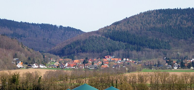
Deutsch: Blick von Westen über die Weser auf Volkmarshausen (Nordteil) und den Austritt des Schedetals ins Wesertal |
Date | |
Source | Own work |
Author | Jan Stubenitzky (Dehio) |
Camera location | 51° 26′ 45.27″ N, 9° 37′ 49.14″ E | View this and other nearby images on: OpenStreetMap | 51.445908; 9.630317 |
---|
Licensing edit
I, the copyright holder of this work, hereby publish it under the following license:
This file is licensed under the Creative Commons Attribution-Share Alike 4.0 International license.
- You are free:
- to share – to copy, distribute and transmit the work
- to remix – to adapt the work
- Under the following conditions:
- attribution – You must give appropriate credit, provide a link to the license, and indicate if changes were made. You may do so in any reasonable manner, but not in any way that suggests the licensor endorses you or your use.
- share alike – If you remix, transform, or build upon the material, you must distribute your contributions under the same or compatible license as the original.
Annotations InfoField | This image is annotated: View the annotations at Commons |
2025
165
1935
711
4000
1852
Hünenburg
10
245
1535
546
4000
1852
Klagesberg (Bramwald)
5
706
835
531
4000
1852
Mühlberg (Bramwald)
2270
1116
120
80
4000
1852
Christuskirche
3340
1156
350
110
4000
1852
Cemetery
665
856
790
345
4000
1852
Schedetal
File history
Click on a date/time to view the file as it appeared at that time.
Date/Time | Thumbnail | Dimensions | User | Comment | |
---|---|---|---|---|---|
current | 11:16, 5 April 2016 | 4,000 × 1,852 (2.89 MB) | Dehio (talk | contribs) | User created page with UploadWizard |
You cannot overwrite this file.
File usage on Commons
The following page uses this file:
File usage on other wikis
The following other wikis use this file:
- Usage on de.wikipedia.org
- Usage on de.wikivoyage.org
- Usage on www.wikidata.org
Metadata
This file contains additional information such as Exif metadata which may have been added by the digital camera, scanner, or software program used to create or digitize it. If the file has been modified from its original state, some details such as the timestamp may not fully reflect those of the original file. The timestamp is only as accurate as the clock in the camera, and it may be completely wrong.
Camera manufacturer | Panasonic |
---|---|
Camera model | DMC-TZ60 |
Exposure time | 1/320 sec (0.003125) |
F-number | f/5.4 |
ISO speed rating | 100 |
Date and time of data generation | 15:31, 2 April 2016 |
Lens focal length | 25.6 mm |
Latitude | 51° 26′ 45.27″ N |
Longitude | 9° 37′ 49.14″ E |
Orientation | Normal |
Horizontal resolution | 180 dpi |
Vertical resolution | 180 dpi |
Software used | GIMP 2.8.14 |
File change date and time | 15:31, 2 April 2016 |
Y and C positioning | Co-sited |
Exposure Program | Aperture priority |
Exif version | 2.3 |
Date and time of digitizing | 15:31, 2 April 2016 |
Meaning of each component |
|
Image compression mode | 4 |
APEX exposure bias | −0.33 |
Maximum land aperture | 4.8671875 APEX (f/5.4) |
Metering mode | Pattern |
Light source | Unknown |
Flash | Flash did not fire, auto mode |
Supported Flashpix version | 1 |
Color space | sRGB |
Sensing method | One-chip color area sensor |
File source | Digital still camera |
Scene type | A directly photographed image |
Custom image processing | Normal process |
Exposure mode | Auto exposure |
White balance | Auto white balance |
Digital zoom ratio | 0 |
Focal length in 35 mm film | 149 mm |
Scene capture type | Standard |
Scene control | None |
Contrast | Normal |
Saturation | Normal |
Sharpness | Normal |
GPS time (atomic clock) | 13:30 |
Receiver status | Measurement in progress |
Measurement mode | 2-dimensional measurement |
Measurement precision | Fair (1.3) |
Geodetic survey data used | WGS-84 |
Name of GPS area | Göttingen |
GPS date | 2 April 2016 |
GPS tag version | 0.0.3.2 |
Date metadata was last modified | 15:31, 2 April 2016 |
Urgency | 0 |
Keywords |
|