File:Vychodoslovenska nizina subdivisions.png
Size of this preview: 588 × 599 pixels. Other resolutions: 235 × 240 pixels | 471 × 480 pixels | 671 × 684 pixels.
Original file (671 × 684 pixels, file size: 32 KB, MIME type: image/png)
Captions
Captions
Add a one-line explanation of what this file represents
Summary edit
| Description |
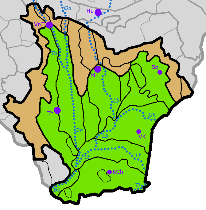
Čeština: Členění geomorfologické oblasti Východoslovenská nížina. Schematicky jsou znázorněny též nejvýznamnější vodní toky a města.
|
| Date | |
| Source | Own work, geomorphic subdivision based on Mazúr & Lukniš, 1986 (Štátny geologický ústav Dionýza Štúra) |
| Author | User:Miaow Miaow |
| Permission (Reusing this file) |
PD-self
|


Licensing edit
| I, the copyright holder of this work, release this work into the public domain. This applies worldwide. In some countries this may not be legally possible; if so: I grant anyone the right to use this work for any purpose, without any conditions, unless such conditions are required by law. |
File history
Click on a date/time to view the file as it appeared at that time.
| Date/Time | Thumbnail | Dimensions | User | Comment | |
|---|---|---|---|---|---|
| current | 22:03, 12 July 2012 | | 671 × 684 (32 KB) | Miaow Miaow (talk | contribs) | {{Information |Description={{cs|Členění geomorfologické oblasti '''Východoslovenská nížina'''. Schematicky jsou znázorněny též nejvýznamnější vodní toky a města. ... |
You cannot overwrite this file.
File usage on Commons
The following 3 pages use this file:
File usage on other wikis
The following other wikis use this file:
- Usage on de.wikipedia.org
- Usage on en.wikipedia.org
- Usage on es.wikipedia.org
- Usage on nn.wikipedia.org
- Usage on pl.wikipedia.org
- Usage on ru.wikipedia.org
- Usage on sk.wikipedia.org
- Usage on uk.wikipedia.org
- Usage on www.wikidata.org