File:Vykort Tånebro cirka 1900.jpg
![File:Vykort Tånebro cirka 1900.jpg](https://upload.wikimedia.org/wikipedia/commons/thumb/b/bc/Vykort_T%C3%A5nebro_cirka_1900.jpg/800px-Vykort_T%C3%A5nebro_cirka_1900.jpg?20231214084314)
Original file (1,626 × 1,048 pixels, file size: 390 KB, MIME type: image/jpeg)
Captions
Captions
Summary
editDescriptionVykort Tånebro cirka 1900.jpg |
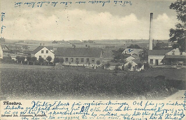
English: Postcard Tånebro Sweden |
Date | |
Source | Webb shop |
Author | Fotograf Joh. Johansson, Rydsgård |
Other versions |
|
Camera location | 55° 27′ 04.6″ N, 13° 35′ 21.66″ E ![]() | View this and other nearby images on: OpenStreetMap | ![]() |
---|
Licensing
editPublic domainPublic domainfalsefalse |
![]() |
This work is in the public domain in its country of origin and other countries and areas where the copyright term is the author's life plus 70 years or fewer.
|
This file has been identified as being free of known restrictions under copyright law, including all related and neighboring rights. |
https://creativecommons.org/publicdomain/mark/1.0/PDMCreative Commons Public Domain Mark 1.0falsefalse
File history
Click on a date/time to view the file as it appeared at that time.
Date/Time | Thumbnail | Dimensions | User | Comment | |
---|---|---|---|---|---|
current | 08:43, 14 December 2023 | ![]() | 1,626 × 1,048 (390 KB) | NilsRoyFranz (talk | contribs) | Uploaded a work by Fotograf Joh. Johansson, Rydsgård from Webb shop with UploadWizard |
You cannot overwrite this file.
File usage on Commons
The following 2 pages use this file:
File usage on other wikis
The following other wikis use this file:
- Usage on sv.wikipedia.org
Metadata
This file contains additional information such as Exif metadata which may have been added by the digital camera, scanner, or software program used to create or digitize it. If the file has been modified from its original state, some details such as the timestamp may not fully reflect those of the original file. The timestamp is only as accurate as the clock in the camera, and it may be completely wrong.
Date and time of data generation | 09:20, 14 December 2023 |
---|---|
Latitude | 55° 27′ 4.6″ N |
Longitude | 13° 35′ 21.66″ E |
Orientation | Normal |
Horizontal resolution | 72 dpi |
Vertical resolution | 72 dpi |
File change date and time | 09:20, 14 December 2023 |
Y and C positioning | Centered |
Exif version | 2.21 |
Date and time of digitizing | 09:20, 14 December 2023 |
Meaning of each component |
|
DateTime subseconds | 619 |
DateTimeOriginal subseconds | 619 |
DateTimeDigitized subseconds | 619 |
Supported Flashpix version | 1 |
Color space | sRGB |
Scene capture type | Standard |
GPS time (atomic clock) | 08:25 |
GPS date | 14 December 2023 |