File:WW2 Holocaust Europe map-pt.svg

Size of this PNG preview of this SVG file: 721 × 600 pixels. Other resolutions: 289 × 240 pixels | 577 × 480 pixels | 923 × 768 pixels | 1,231 × 1,024 pixels | 2,461 × 2,048 pixels | 1,310 × 1,090 pixels.
Original file (SVG file, nominally 1,310 × 1,090 pixels, file size: 589 KB)
Captions
Captions
Add a one-line explanation of what this file represents
Summary edit
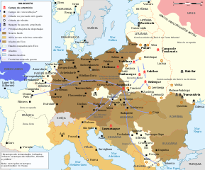
| Description |
Português: Mapa do Holocausto na Europa entre 1939 e 1945 |
| Date | |
| Source |
This file was derived from: WW2 Holocaust Europe N-E map-fr.svg: |
| Author | Sémhur |
| Other versions |
[]
|


.png)


.png)


Licensing edit
This file is licensed under the Creative Commons Attribution-Share Alike 4.0 International license.
- You are free:
- to share – to copy, distribute and transmit the work
- to remix – to adapt the work
- Under the following conditions:
- attribution – You must give appropriate credit, provide a link to the license, and indicate if changes were made. You may do so in any reasonable manner, but not in any way that suggests the licensor endorses you or your use.
- share alike – If you remix, transform, or build upon the material, you must distribute your contributions under the same or compatible license as the original.
File history
Click on a date/time to view the file as it appeared at that time.
| Date/Time | Thumbnail | Dimensions | User | Comment | |
|---|---|---|---|---|---|
| current | 18:12, 31 December 2019 | | 1,310 × 1,090 (589 KB) | Renato de Carvalho Ferreira (talk | contribs) | User created page with UploadWizard |
You cannot overwrite this file.
File usage on Commons
The following 24 pages use this file:
- File:WW2-Holocaust-Europe-2007Borders.png
- File:WW2-Holocaust-Europe-2007Borders DE.png
- File:WW2-Holocaust-Europe-he.png
- File:WW2-Holocaust-Europe.png
- File:WW2-Holocaust-Europe DE.png
- File:WW2-Holocaust-Europe DE 2.png
- File:WW2-Holocaust-Europe blank.png
- File:WW2-Holocaust-Poland-ru.png
- File:WW2-Holocaust-Poland-ukr.jpg
- File:WW2-Holocaust-Poland.PNG
- File:WW2-Holocaust-Poland (Français).png
- File:WW2-Holocaust-Poland (without comment).png
- File:WW2-Holocaust-Poland big legend.PNG
- File:WW2-Zagłada-Żydów-Polska.png
- File:WW2 Holocaust Europe N-E map-fr.svg
- File:WW2 Holocaust Europe map-blank.svg
- File:WW2 Holocaust Europe map-es.svg
- File:WW2 Holocaust Europe map-fr.svg
- File:WW2 Holocaust Europe map-it.svg
- File:WW2 Holocaust Europe map-pt.svg
- File:WW2 Holocaust Europe map-zh-hans.svg
- File:WW2 Holocaust Poland map-fr.svg
- File:Холокост в Европе.png
- Template:Other versions/WW2 Holocaust Europe map
File usage on other wikis
The following other wikis use this file:
- Usage on gl.wikipedia.org
- Usage on pt.wikipedia.org