File:Wakayama Shingu high school, CKK20113X-C14-25.jpg
No higher resolution available.
Wakayama_Shingu_high_school,_CKK20113X-C14-25.jpg (254 × 255 pixels, file size: 37 KB, MIME type: image/jpeg)
Captions
Captions
Add a one-line explanation of what this file represents
Summary
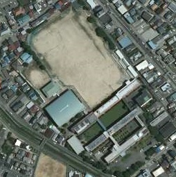
edit| Description |
日本語: 和歌山県新宮市神倉三丁目にある、和歌山県立新宮高等学校の空中写真。
English: This is an aerial photo of Wakayama prefectural Shingu high school in Singu, Wakayama, Japan. |
| Date | |
| Source |
日本語: 国土画像情報(カラー空中写真)(整理番号:CKK20113X、コース番号:C14、写真番号:25、撮影年月日:2011年9月6日、撮影地域:台風12号災害、撮影高度:4386m、撮影縮尺:1/20000、カメラ名称:UCD、焦点距離:105.200mm、カラー種別:カラー、写真種別:デジタル、撮影計画機関:国土地理院、市区町村名:新宮市) http://mapps.gsi.go.jp/contentsImageDisplay.do?specificationId=1216227&isDetail=false
English: National Land Image Information (Color Aerial Photographs) (Reference number: CKK20113X; Course Number: C14; Photo Number: 25; Date: September 6, 2011; Area: Tropical Storm Talas-stricken area; Height: 4386 metre; Scale: 1/20000; Camera Name: UCD; Focal Distance: 105.200 millimetre; Color Type: Color; Photo Type: Digital; Agency: Geographical Survey Institute of Japan; Municipality: Singu City) http://mapps.gsi.go.jp/contentsImageDisplay.do?specificationId=1216227&isDetail=false |
| Author |
English: Geographical Survey Institute of Japan 日本語: 国土地理院 |
Licensing
edit
|
The copyright holder of this file, Ministry of Land, Infrastructure, Transport and Tourism, allows anyone to use it for any purpose, provided that the copyright holder is properly attributed. Redistribution, derivative work, commercial use, and all other use is permitted. |
Attribution:
National Land Image Information (Color Aerial Photographs), created by Ministry of Land, Infrastructure, Transport and Tourism, distributed by Geospatial Information Authority of Japan
|

File history
Click on a date/time to view the file as it appeared at that time.
| Date/Time | Thumbnail | Dimensions | User | Comment | |
|---|---|---|---|---|---|
| current | 15:35, 30 March 2017 | | 254 × 255 (37 KB) | Miyuki Meinaka (talk | contribs) | User created page with UploadWizard |
You cannot overwrite this file.
File usage on Commons
The following 2 pages use this file:
File usage on other wikis
The following other wikis use this file:
- Usage on ja.wikipedia.org
- Usage on www.wikidata.org