File:Wakiso District in Uganda.svg

Size of this PNG preview of this SVG file: 589 × 599 pixels. Other resolutions: 236 × 240 pixels | 472 × 480 pixels | 755 × 768 pixels | 1,007 × 1,024 pixels | 2,013 × 2,048 pixels | 1,441 × 1,466 pixels.
Original file (SVG file, nominally 1,441 × 1,466 pixels, file size: 370 KB)
Captions
Captions
Add a one-line explanation of what this file represents
Summary
edit
| Description |
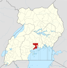
English: The location of Wakiso District in Uganda, showing district boundaries as they stood in June 2017. For other districts, see Category:SVG locator maps of Districts in Uganda (location map scheme). This map may be incomplete, and may contain errors. Don't rely solely on it for navigation. In particular, note that this map overlays a spherical pseudo-mercator projection on an equirectangular projection; it is far from technically perfect.
This W3C-unspecified vector image was created with Inkscape . |
|||||||||
| Date | ||||||||||
| Source |
Derivative of:
|
|||||||||
| Creator |
OpenStreetMap contributors, Jarry1250, NordNordWest |
|||||||||
| Permission (Reusing this file) |
This file is licensed under the Creative Commons Attribution-Share Alike 3.0 Unported license. Attribution: © OpenStreetMap contributors, Jarry1250, NordNordWest/Wikipedia
|
|||||||||
| Geotemporal data | ||||||||||
| Map location | Wakiso District, Uganda | |||||||||
| Spatial reference system | equirectangular | |||||||||
| Bounding box |
|
|||||||||
| Georeferencing | If inappropriate please set warp_status = skip to hide. | |||||||||
File history
Click on a date/time to view the file as it appeared at that time.
| Date/Time | Thumbnail | Dimensions | User | Comment | |
|---|---|---|---|---|---|
| current | 21:11, 25 June 2017 | | 1,441 × 1,466 (370 KB) | Jarry1250 (talk | contribs) | pattypan 17.05 |
You cannot overwrite this file.
File usage on Commons
The following page uses this file:
File usage on other wikis
The following other wikis use this file:
- Usage on ar.wikipedia.org
- Usage on de.wikipedia.org
- Usage on en.wikipedia.org
- Entebbe
- Entebbe International Airport
- Wakiso District
- Nkumba University
- Lubowa
- Kasangati
- King's College, Budo
- Kakiri
- Mayanja River
- Kira Town
- Wakiso Town
- Namugongo
- Gayaza High School
- Kampala–Jinja Highway
- Uganda Clays Limited
- Nansana
- Bweyogerere
- Matugga
- Gombe, Wakiso
- Sentema
- Nsangi
- Buddo hill
- Matugga–Kapeeka Road
- Kireka
- Gayaza–Ziroobwe Road
- Gayaza
- Kampala Northern Bypass Highway
- African Bible University (Uganda)
- Najjera
- Najjanankumbi
- Bulindo
- Nsasa
- Wikipedia:WikiProject Uganda/District templates
- Template:Wakiso District
- Kajjansi Airfield
- Kajjansi
- Namulonge Airport
- Namulonge
- Naalya
- Imperial Resort Beach Hotel
- Lake Victoria Serena Resort
- Lweeza
- Namanve
- Kampala Industrial and Business Park
- Roofings Group
- Mutundwe
- Entebbe–Kampala Expressway
- St. Mary's College Kisubi
View more global usage of this file.