File:Wantyn Dyke - geograph.org.uk - 1064364.jpg
No higher resolution available.
Wantyn_Dyke_-_geograph.org.uk_-_1064364.jpg (640 × 480 pixels, file size: 79 KB, MIME type: image/jpeg)
Captions
Captions
Add a one-line explanation of what this file represents
Summary
edit
| Description |
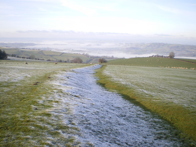
English: Wantyn Dyke. Nowadays little more than a shallow ditch running down the field, although it must have been a more impressive sight when it was first constructed. Its line can be traced further to the northwest, through SO1891 and SO1990, before it stops being marked on the modern maps.
|
| Date | |
| Source | From geograph.org.uk |
| Author | Richard Law |
| Attribution (required by the license) | Richard Law / Wantyn Dyke / |
| Camera location | | View this and other nearby images on: OpenStreetMap |
|---|
_heading:292.00&language=en)
| Object location | | View this and other nearby images on: OpenStreetMap |
|---|
_heading:292.00&language=en)
Licensing
edit

|
This image was taken from the Geograph project collection. See this photograph's page on the Geograph website for the photographer's contact details. The copyright on this image is owned by Richard Law and is licensed for reuse under the Creative Commons Attribution-ShareAlike 2.0 license.
|
This file is licensed under the Creative Commons Attribution-Share Alike 2.0 Generic license.
Attribution: Richard Law
- You are free:
- to share – to copy, distribute and transmit the work
- to remix – to adapt the work
- Under the following conditions:
- attribution – You must give appropriate credit, provide a link to the license, and indicate if changes were made. You may do so in any reasonable manner, but not in any way that suggests the licensor endorses you or your use.
- share alike – If you remix, transform, or build upon the material, you must distribute your contributions under the same or compatible license as the original.

|
The categories of this image need checking. You can do so here.
|
File history
Click on a date/time to view the file as it appeared at that time.
| Date/Time | Thumbnail | Dimensions | User | Comment | |
|---|---|---|---|---|---|
| current | 05:40, 24 February 2011 | | 640 × 480 (79 KB) | GeographBot (talk | contribs) | == {{int:filedesc}} == {{Information |description={{en|1=Wantyn Dyke Nowadays little more than a shallow ditch running down the field, although it must have been a more impressive sight when it was first constructed. Its line can be traced further to the |
You cannot overwrite this file.
File usage on Commons
There are no pages that use this file.