File:WarRelocationMap.jpg

No higher resolution available.
WarRelocationMap.jpg (628 × 408 pixels, file size: 128 KB, MIME type: image/jpeg)
Captions
Captions
Add a one-line explanation of what this file represents
Summary edit
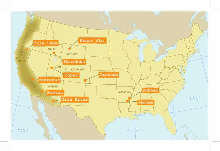
| Description | アメリカ合衆国日系人収容所所在地地図 |
| Source |
http://www.nps.gov/manz/historyculture/images/WarRelocationMap.jpg |
| Author | The National Park Service (NPS), U.S. Department of the Interior |
Licensing edit
| This image or media file contains material based on a work of a National Park Service employee, created as part of that person's official duties. As a work of the U.S. federal government, such work is in the public domain in the United States. See the NPS website and NPS copyright policy for more information. |
File history
Click on a date/time to view the file as it appeared at that time.
| Date/Time | Thumbnail | Dimensions | User | Comment | |
|---|---|---|---|---|---|
| current | 16:20, 16 October 2020 | | 628 × 408 (128 KB) | WFinch (talk | contribs) | no crops |
| 15:08, 25 September 2006 |  | 700 × 480 (27 KB) | Californiacondor~commonswiki (talk | contribs) | アメリカ合衆国日系人収容所所在地地図 |
You cannot overwrite this file.
File usage on Commons
The following page uses this file:
File usage on other wikis
The following other wikis use this file:
- Usage on ca.wikipedia.org
- Usage on en.wikipedia.org
- Usage on fr.wikipedia.org
- Usage on ja.wikipedia.org
- Usage on www.wikidata.org