File:Warsaw streetcar network before 1939.svg

Size of this PNG preview of this SVG file: 652 × 600 pixels. Other resolutions: 261 × 240 pixels | 522 × 480 pixels | 835 × 768 pixels | 1,113 × 1,024 pixels | 2,226 × 2,048 pixels.
Original file (SVG file, nominally 800 × 736 pixels, file size: 1.06 MB)
Captions
Captions
Add a one-line explanation of what this file represents
Summary
edit
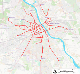
| Description | Map of warsaw tramway network, before destruction of network in 1945 |
| Date | |
| Source |
http://sharemap.org/public/Warsaw_streetcar_network_before_1939 Geospatial data sources:
|
| Author | Jkan997 |
| SVG development | This W3C-invalid map was created with ShareMap.org. |
Thumbnail with colored legend in caption
edit

[[File:Warsaw_streetcar_network_before_1939.svg|thumb|<center>Map of warsaw tramway network before destruction in 1945 {{nowrap|([[ShareMap:public/Warsaw_streetcar_network_before_1939|interactive version]])}}]]
Licensing
edit
I, the copyright holder of this work, hereby publish it under the following licenses:
This file is licensed under the Creative Commons Attribution-Share Alike 3.0 Unported license.
- You are free:
- to share – to copy, distribute and transmit the work
- to remix – to adapt the work
- Under the following conditions:
- attribution – You must give appropriate credit, provide a link to the license, and indicate if changes were made. You may do so in any reasonable manner, but not in any way that suggests the licensor endorses you or your use.
- share alike – If you remix, transform, or build upon the material, you must distribute your contributions under the same or compatible license as the original.

|
Permission is granted to copy, distribute and/or modify this document under the terms of the GNU Free Documentation License, Version 1.2 or any later version published by the Free Software Foundation; with no Invariant Sections, no Front-Cover Texts, and no Back-Cover Texts. A copy of the license is included in the section entitled GNU Free Documentation License. |
You may select the license of your choice.
File history
Click on a date/time to view the file as it appeared at that time.
| Date/Time | Thumbnail | Dimensions | User | Comment | |
|---|---|---|---|---|---|
| current | 22:33, 21 May 2012 | | 800 × 736 (1.06 MB) | Jkan997 (talk | contribs) | {{Information |Description=Map of warsaw tramway network, before destruction of network in 1945 |Source = http://sharemap.org/public/Warsaw_streetcar_network_before_1939 Geospatial data sources: * <a href="http://wiki.openstreetmap.org/wiki/OpenStree... |
You cannot overwrite this file.
File usage on Commons
The following page uses this file:
File usage on other wikis
The following other wikis use this file:
- Usage on ba.wikipedia.org
- Usage on de.wikipedia.org
- Usage on en.wikipedia.org
- Usage on fr.wikipedia.org
- Usage on hy.wikipedia.org
- Usage on ja.wikipedia.org
- Usage on pl.wikipedia.org
- Usage on ru.wikipedia.org
- Usage on sk.wikipedia.org
- Usage on www.wikidata.org