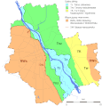
File:Warszawa geomorfologia Wisła taras zalewowy mapa.gif

Size of this preview: 577 × 599 pixels. Other resolutions: 231 × 240 pixels | 462 × 480 pixels | 770 × 800 pixels.
Original file (770 × 800 pixels, file size: 60 KB, MIME type: image/gif)
File information
Structured data
Captions
Captions
Add a one-line explanation of what this file represents
| Open this image as an overlay in Google Earth (Google Maps, Bing) | (Help|Source) |
Summary
edit| DescriptionWarszawa geomorfologia Wisła taras zalewowy mapa.gif |
Polski: Główne jednostki geomorfologiczne w Warszawie. Skróty stosowane w literaturze: Skróty dodane przez użytkownika Darekk2: |
| Date | |
| Source |
Own work using: (praca własna z wykorzystaniem:) Polski: wymienionych niżej pozycji literaturowych jako źródeł przebiegu granic jednostek geomorfologicznych, który jest ich kompilacją i przetworzeniem: English: the literature positions listed below as sources of delineation of the boundaries between geomorphological units, which is their compilation and transformation:
|
| Author |
Polski: Darekk2 na podstawie powyższej literatury English: Darekk2 on the basis of the above literature |
Licensing
editPolski: Uznanie autorstwa: Autor tej mapy i prawdopodobnie wymienieni wyżej oryginalni autorzy i źródła przebiegu granic pomiędzy jednostkami geomorfologicznymi (zaznaczając, że jest on ich kompilacją i przetworzeniem).
English: Attribution: The author of the map and probably the listed above original authors and sources of delineation of the boundaries between geomorphological units (indicating, that it is their compilation and transformation).
This file is licensed under the Creative Commons Attribution-Share Alike 4.0 International license.
Attribution: The author of the work
and probably the original authors and sources
of delineation of the boundaries between geological units
and probably the original authors and sources
of delineation of the boundaries between geological units
- You are free:
- to share – to copy, distribute and transmit the work
- to remix – to adapt the work
- Under the following conditions:
- attribution – You must give appropriate credit, provide a link to the license, and indicate if changes were made. You may do so in any reasonable manner, but not in any way that suggests the licensor endorses you or your use.
- share alike – If you remix, transform, or build upon the material, you must distribute your contributions under the same or compatible license as the original.
File history
Click on a date/time to view the file as it appeared at that time.
| Date/Time | Thumbnail | Dimensions | User | Comment | |
|---|---|---|---|---|---|
| current | 14:28, 29 January 2015 |  | 770 × 800 (60 KB) | Darekk2 (talk | contribs) | tunning |
| 17:56, 17 January 2015 |  | 770 × 800 (60 KB) | Darekk2 (talk | contribs) | skasowanie dwóch rowów | |
| 11:40, 15 October 2014 |  | 770 × 800 (60 KB) | Darekk2 (talk | contribs) | Changed locally the course of the Równina Warszawska border in NW | |
| 11:18, 15 October 2014 |  | 770 × 800 (60 KB) | Darekk2 (talk | contribs) | Changed the course of the Równina Warszawska border | |
| 09:36, 15 October 2014 |  | 770 × 800 (60 KB) | Darekk2 (talk | contribs) | User created page with UploadWizard |
You cannot overwrite this file.
File usage on Commons
There are no pages that use this file.
File usage on other wikis
The following other wikis use this file:
- Usage on pl.wikipedia.org