File:Water Troughs at Eyam-2.jpg

Size of this preview: 800 × 533 pixels. Other resolutions: 320 × 213 pixels | 640 × 427 pixels | 1,024 × 683 pixels | 1,280 × 853 pixels | 1,806 × 1,204 pixels.
Original file (1,806 × 1,204 pixels, file size: 1.02 MB, MIME type: image/jpeg)
Captions
Captions
Add a one-line explanation of what this file represents
Summary
edit
| Description |
English: Wall And Water Troughs To South East Of Edge Moor
|
|
| Date | ||
| Source | Own work | |
| Author | Barrie Price |
| Camera location | | View this and other nearby images on: OpenStreetMap |
|---|
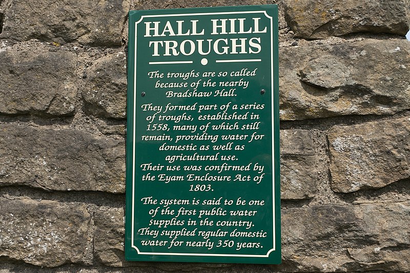
Eyam village has at the roadside several water troughs which are what remains of a series of troughs established in 1558. The troughs provided water for domestic as well as agricultural use and there use was confirmed by the Eyam Enclosure Act of 1803.
The system is said to be one of the first public water supplies in the country supplying regular domestic water for nearly 350 years.
Licensing
edit
I, the copyright holder of this work, hereby publish it under the following license:
This file is licensed under the Creative Commons Attribution-Share Alike 4.0 International license.
- You are free:
- to share – to copy, distribute and transmit the work
- to remix – to adapt the work
- Under the following conditions:
- attribution – You must give appropriate credit, provide a link to the license, and indicate if changes were made. You may do so in any reasonable manner, but not in any way that suggests the licensor endorses you or your use.
- share alike – If you remix, transform, or build upon the material, you must distribute your contributions under the same or compatible license as the original.

|
This image was uploaded as part of Wiki Loves Monuments 2018.
|
File history
Click on a date/time to view the file as it appeared at that time.
| Date/Time | Thumbnail | Dimensions | User | Comment | |
|---|---|---|---|---|---|
| current | 08:39, 14 September 2018 | | 1,806 × 1,204 (1.02 MB) | Barrie Price (talk | contribs) | User created page with UploadWizard |
You cannot overwrite this file.
File usage on Commons
There are no pages that use this file.