File:Water Vapor Systems Seen From GOES-15 and GOES-13 Satellites, 12 September 2013.gif
Size of this preview: 800 × 538 pixels. Other resolutions: 320 × 215 pixels | 640 × 431 pixels | 1,024 × 689 pixels | 1,385 × 932 pixels.
Original file (1,385 × 932 pixels, file size: 9.8 MB, MIME type: image/gif, looped, 23 frames, 6.9 s)
Captions
Captions
Add a one-line explanation of what this file represents
Summary edit
| Description |
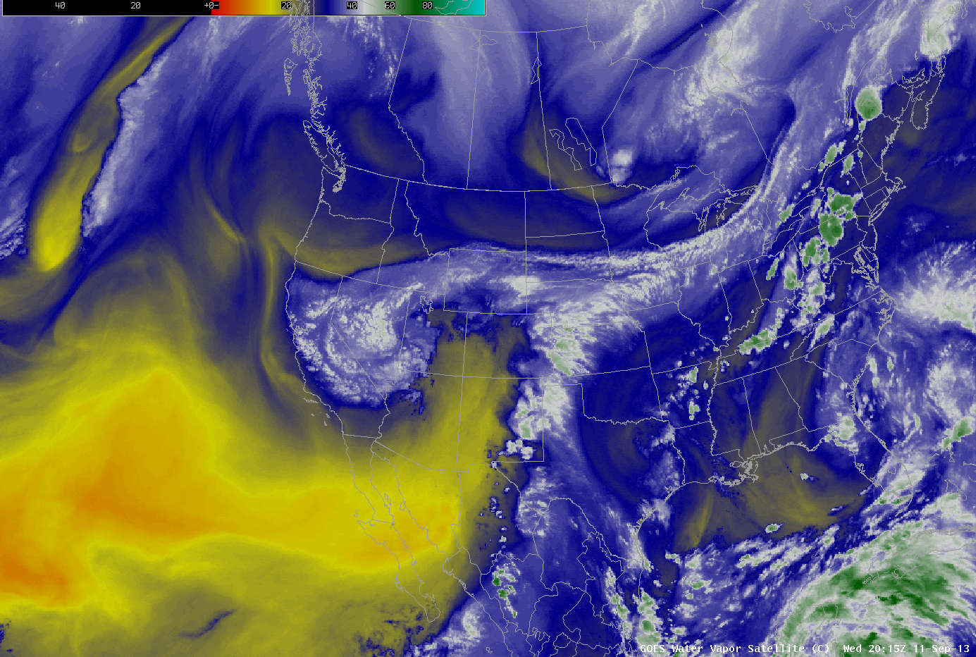
English: This is an animated loop of water vapor systems over the western area of North America on September 12th, 2013 as shown by the GOES- 15 and GOES-13 satellites. The storm that caused the 2013 Colorado flooding was kept in a confined area over the Eastern Range of the Rocky Mountains in Colorado by these water vapor systems. |
| Date | |
| Source | http://cimss.ssec.wisc.edu/goes/blog/archives/13876 |
| Author | Cooperative Institute for Meteorological Satellite Studies (CIMSS), University of Wisconsin – Madison, USA |
| Other versions | http://ccentralassets.s3.amazonaws.com/NA_Water_Vapor_20130912loop.gif |
Licensing edit
This image is in the public domain because it contains materials that originally came from the U.S. National Oceanic and Atmospheric Administration, taken or made as part of an employee's official duties.
|
File history
Click on a date/time to view the file as it appeared at that time.
| Date/Time | Thumbnail | Dimensions | User | Comment | |
|---|---|---|---|---|---|
| current | 05:05, 13 November 2013 | | 1,385 × 932 (9.8 MB) | Jonathanhoffmann225 (talk | contribs) | {{subst:Upload marker added by en.wp UW}} {{Information |Description = {{en|This is an animated loop of water vapor systems over the western area of North America on September 12th, 2013 as shown by the GOES- 15 and GOES-13 satellites. The storm that c... |
You cannot overwrite this file.
File usage on Commons
The following 2 pages use this file:
- File:Water Vapor Systems Seen From GOES-15 and GOES-13 Satellites 12 September 2013Reduced.gif (file redirect)
- File:Water vapor gif.gif (file redirect)
File usage on other wikis
The following other wikis use this file:
- Usage on en.wikipedia.org
- Usage on ru.wikinews.org