File:Waverley Line.png
Size of this preview: 733 × 599 pixels. Other resolutions: 294 × 240 pixels | 587 × 480 pixels | 940 × 768 pixels | 1,253 × 1,024 pixels | 2,438 × 1,993 pixels.
Original file (2,438 × 1,993 pixels, file size: 3.08 MB, MIME type: image/png)
Captions
Captions
Add a one-line explanation of what this file represents

| Description |
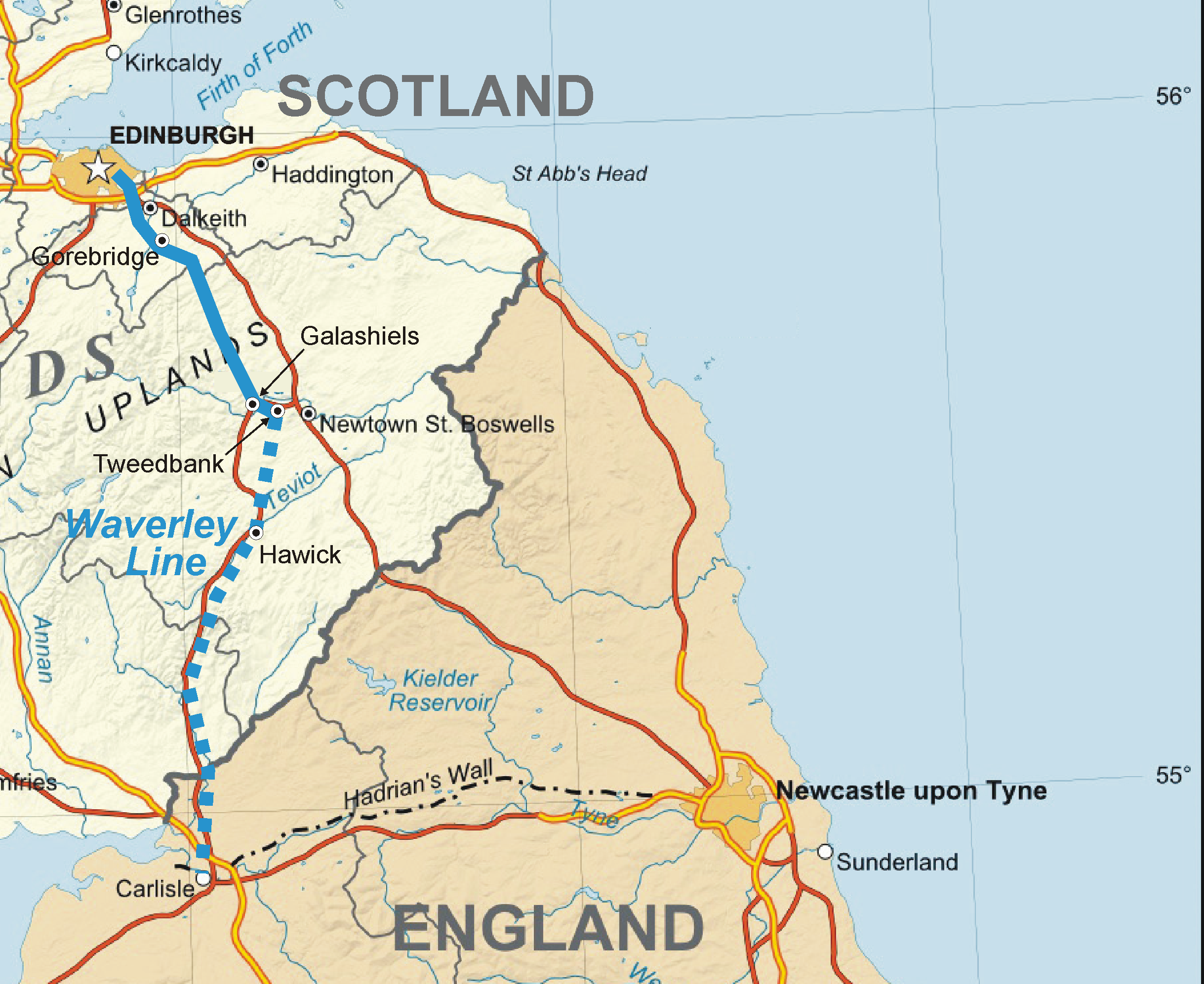
English: Map of the en:Waverley Line in Scotland, partly under construction as of 2011, partly closed. |
| Date | (UTC) |
| Source | |
| Author |
|
I, the copyright holder of this work, hereby publish it under the following licenses:
This file is licensed under the Creative Commons Attribution-Share Alike 3.0 Unported, 2.5 Generic, 2.0 Generic and 1.0 Generic license.
- You are free:
- to share – to copy, distribute and transmit the work
- to remix – to adapt the work
- Under the following conditions:
- attribution – You must give appropriate credit, provide a link to the license, and indicate if changes were made. You may do so in any reasonable manner, but not in any way that suggests the licensor endorses you or your use.
- share alike – If you remix, transform, or build upon the material, you must distribute your contributions under the same or compatible license as the original.

|
Permission is granted to copy, distribute and/or modify this document under the terms of the GNU Free Documentation License, Version 1.2 or any later version published by the Free Software Foundation; with no Invariant Sections, no Front-Cover Texts, and no Back-Cover Texts. A copy of the license is included in the section entitled GNU Free Documentation License. |
You may select the license of your choice.
Original upload log edit
This image is a derivative work of the following images:
- File:Scotland_map-en.jpg licensed with Cc-by-sa-3.0,2.5,2.0,1.0, GFDL
- 2010-07-17T21:37:14Z Sting 2400x3450 (2273674 Bytes) Color profile
- 2008-06-17T22:28:20Z Sting 2400x3450 (2188752 Bytes) Colors modified
- 2007-12-14T01:24:15Z Sting 2400x3450 (2326842 Bytes) Additional name
- 2007-12-13T19:53:38Z Sting 2400x3450 (2322796 Bytes) {{Location|57|00|00|N|04|00|00|W|scale:4000000}} {{Information |Description=Map in English of [[:en:Scotland|Scotland]]This is a lighter raster JPG format version of [[:Image:Scotland_map-en.svg]] which should be used in the
Also used File:Ordnance_Survey_1-250000_-_NT.jpg.
Uploaded with derivativeFX
File history
Click on a date/time to view the file as it appeared at that time.
| Date/Time | Thumbnail | Dimensions | User | Comment | |
|---|---|---|---|---|---|
| current | 13:05, 7 September 2011 | | 2,438 × 1,993 (3.08 MB) | Classical geographer (talk | contribs) | {{Information |Description={{en|Map of the Waverley Line in Scotland, partly under construction as of 2011, partly closed.}} |Source=*File:Scotland_map-en.jpg |Date=2011-09-07 13:04 (UTC) |Author=*File:Scotland_map-en.jpg: Eric Gaba ([[Us |
You cannot overwrite this file.
File usage on Commons
There are no pages that use this file.
File usage on other wikis
The following other wikis use this file:
- Usage on en.wikipedia.org