File:Waverley Line 2015 en.png
Size of this preview: 567 × 599 pixels. Other resolutions: 227 × 240 pixels | 454 × 480 pixels | 726 × 768 pixels | 968 × 1,024 pixels | 2,234 × 2,362 pixels.
Original file (2,234 × 2,362 pixels, file size: 3.02 MB, MIME type: image/png)
Captions
Captions
Add a one-line explanation of what this file represents
Summary edit
| Description |
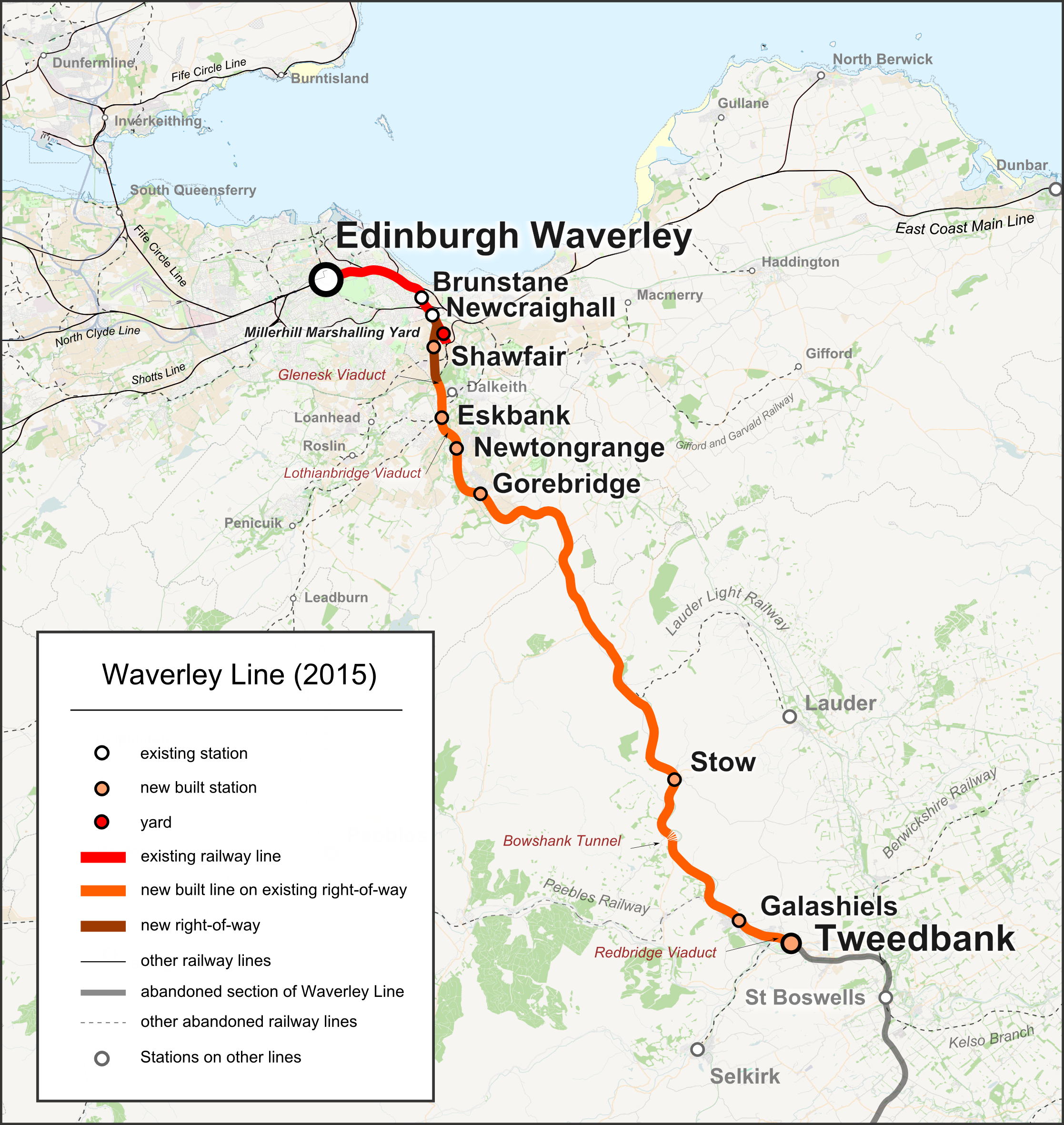
English: Map of the en:Waverley Line in Scotland, as it will be opened in September 2015. English language captions. |
| Date | |
| Source |
|
| Author | |
| Permission (Reusing this file) |
Map data (c) OpenStreetMap (and) contributors, CC-BY-SA |
| Other versions |
|


Licensing edit
This file is licensed under the Creative Commons Attribution-Share Alike 2.0 Generic license.
- You are free:
- to share – to copy, distribute and transmit the work
- to remix – to adapt the work
- Under the following conditions:
- attribution – You must give appropriate credit, provide a link to the license, and indicate if changes were made. You may do so in any reasonable manner, but not in any way that suggests the licensor endorses you or your use.
- share alike – If you remix, transform, or build upon the material, you must distribute your contributions under the same or compatible license as the original.
File history
Click on a date/time to view the file as it appeared at that time.
| Date/Time | Thumbnail | Dimensions | User | Comment | |
|---|---|---|---|---|---|
| current | 13:58, 15 September 2018 | | 2,234 × 2,362 (3.02 MB) | Pechristener (talk | contribs) | Fife Circle Line instead of Five Circle Line |
| 12:03, 1 April 2015 |  | 2,234 × 2,362 (3.01 MB) | Pechristener (talk | contribs) | some small fixes in the caption | |
| 18:39, 30 March 2015 |  | 2,234 × 2,362 (3.02 MB) | Pechristener (talk | contribs) | {{Information |Description={{en|Map of the en:Waverley Line in Scotland, as it will be opened in September 2015. Catpion English}} |Source=*{{own}}, map was created using [http://www.openstreetmap.org/ Open Street Map] |Date=2015-03-30 |Author=*[[... |
You cannot overwrite this file.
File usage on Commons
The following 5 pages use this file:
File usage on other wikis
The following other wikis use this file:
- Usage on en.wikipedia.org