File:Weißwasser Sowjetisches Ehrenmal (00).jpg
![File:Weißwasser Sowjetisches Ehrenmal (00).jpg](https://upload.wikimedia.org/wikipedia/commons/thumb/b/be/Wei%C3%9Fwasser_Sowjetisches_Ehrenmal_%2800%29.jpg/800px-Wei%C3%9Fwasser_Sowjetisches_Ehrenmal_%2800%29.jpg?20151130191831)
Size of this preview: 800 × 456 pixels. Other resolutions: 320 × 182 pixels | 640 × 365 pixels | 1,024 × 584 pixels | 1,354 × 772 pixels.
Original file (1,354 × 772 pixels, file size: 976 KB, MIME type: image/jpeg)
File information
Structured data
Captions
Captions
Add a one-line explanation of what this file represents
Summary
editDescriptionWeißwasser Sowjetisches Ehrenmal (00).jpg |
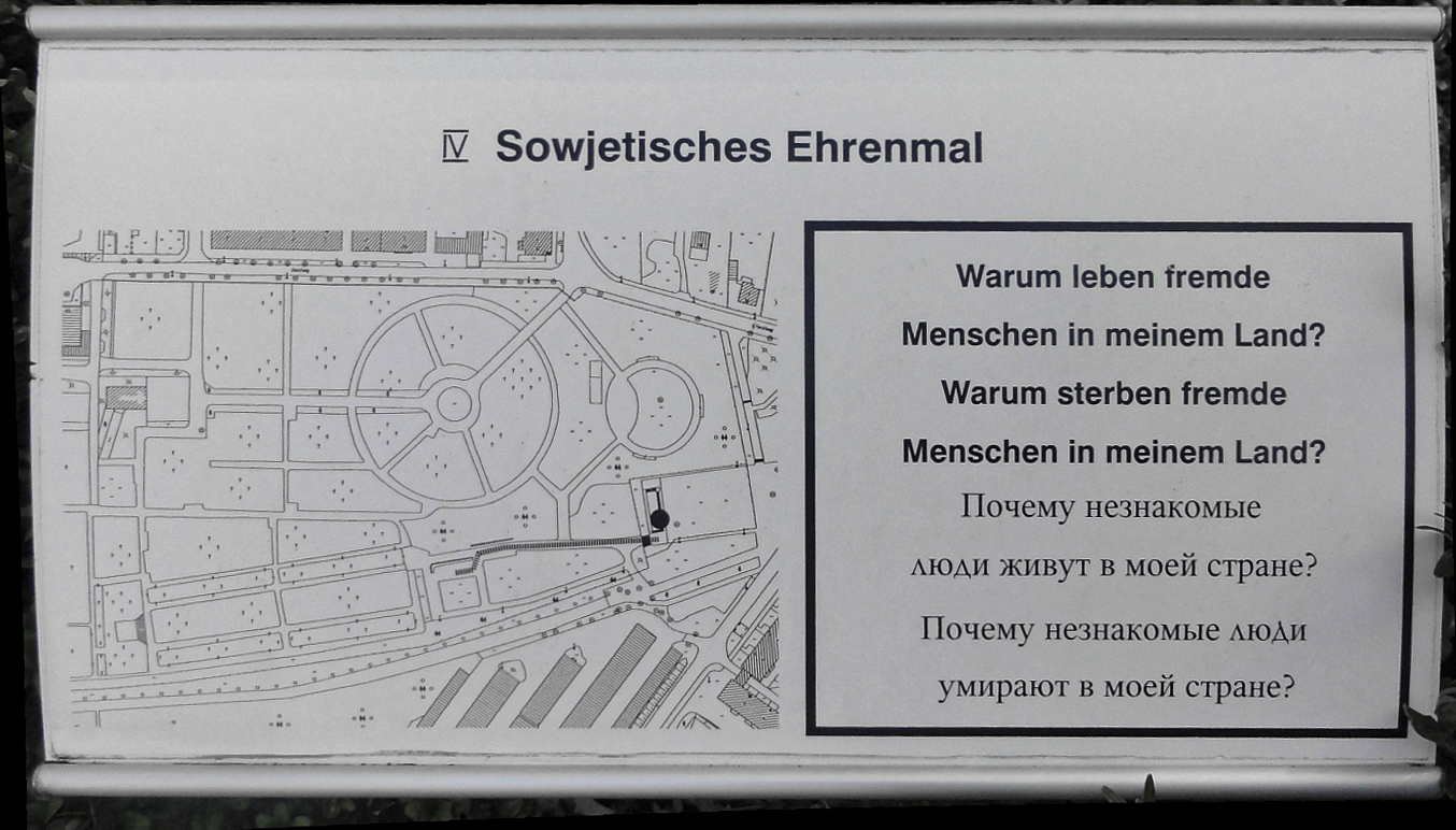
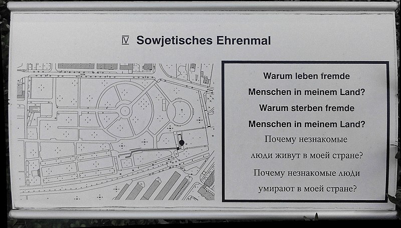
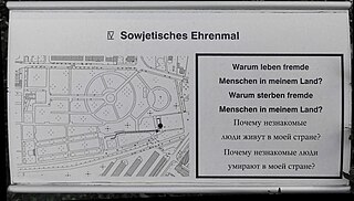
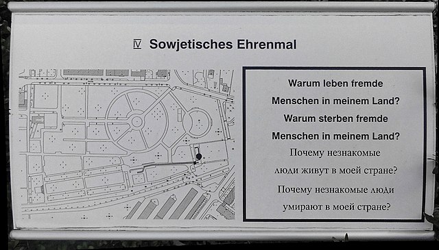
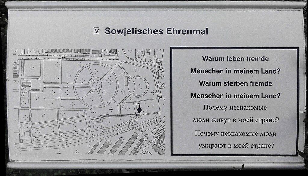
Deutsch: Informationstafel zum Ehrenhain für die gefallenen sowjetischen Soldaten in Weißwasser, Einweihung 7. Oktober 1974, Friedhofsgelände, Entwurf Herbert Burschik, Kulturdenkmal
English: Information plate to the Memorial in honor to the fallen soviet soldiers in Weißwasser, official opening at october 7th 1974, Area of city cemetery, Design by Herbert Burschik, Cultural heritage monument |
Date | |
Source | Own work |
Author | Tommes |
Attribution (required by the license) InfoField | Tommes / Wikimedia Commons / CC-BY-SA-4.0 |
InfoField | Tommes / Wikimedia Commons |
Camera location | 51° 30′ 04.74″ N, 14° 37′ 35.67″ E ![]() ![]() | View this and other nearby images on: OpenStreetMap | ![]() |
---|
Object location | 51° 30′ 05.36″ N, 14° 37′ 35.11″ E ![]() | View this and other nearby images on: OpenStreetMap | ![]() |
---|
(Wikidata) |
This is a retouched picture, which means that it has been digitally altered from its original version. Modifications: Distortion. Modifications made by Hic et nunc.
|
Licensing
editI, the copyright holder of this work, hereby publish it under the following license:
![w:en:Creative Commons](https://upload.wikimedia.org/wikipedia/commons/thumb/7/79/CC_some_rights_reserved.svg/90px-CC_some_rights_reserved.svg.png)
![attribution](https://upload.wikimedia.org/wikipedia/commons/thumb/1/11/Cc-by_new_white.svg/24px-Cc-by_new_white.svg.png)
![share alike](https://upload.wikimedia.org/wikipedia/commons/thumb/d/df/Cc-sa_white.svg/24px-Cc-sa_white.svg.png)
This file is licensed under the Creative Commons Attribution-Share Alike 4.0 International license.
- You are free:
- to share – to copy, distribute and transmit the work
- to remix – to adapt the work
- Under the following conditions:
- attribution – You must give appropriate credit, provide a link to the license, and indicate if changes were made. You may do so in any reasonable manner, but not in any way that suggests the licensor endorses you or your use.
- share alike – If you remix, transform, or build upon the material, you must distribute your contributions under the same or compatible license as the original.
File history
Click on a date/time to view the file as it appeared at that time.
Date/Time | Thumbnail | Dimensions | User | Comment | |
---|---|---|---|---|---|
current | 19:18, 30 November 2015 | ![]() | 1,354 × 772 (976 KB) | Tommes (talk | contribs) | == {{int:filedesc}} == {{Information |Description = {{de|1=Informationstafel zum Ehrenhain für die gefallenen sowjetischen Soldaten in Weißwasser, Einweihung 7. Oktober 1974, Friedhofsgelände, Entwurf Herbert Burschik, Kulturdenkmal}} {{en|1=Info... |
You cannot overwrite this file.
File usage on Commons
There are no pages that use this file.
Metadata
This file contains additional information such as Exif metadata which may have been added by the digital camera, scanner, or software program used to create or digitize it. If the file has been modified from its original state, some details such as the timestamp may not fully reflect those of the original file. The timestamp is only as accurate as the clock in the camera, and it may be completely wrong.
Camera manufacturer | SONY |
---|---|
Camera model | DSC-HX5V |
Exposure time | 1/400 sec (0.0025) |
F-number | f/3.5 |
ISO speed rating | 125 |
Date and time of data generation | 13:24, 24 October 2015 |
Lens focal length | 4.25 mm |
Latitude | 51° 30′ 4.74″ N |
Longitude | 14° 37′ 35.67″ E |
Altitude | 144.4 meters above sea level |
City shown | Weißwasser |
Orientation | Normal |
Horizontal resolution | 72 dpi |
Vertical resolution | 72 dpi |
Software used | DxO OpticsPro 10.0 |
File change date and time | 13:24, 24 October 2015 |
Y and C positioning | Co-sited |
Exposure Program | Normal program |
Exif version | 2.21 |
Date and time of digitizing | 13:24, 24 October 2015 |
Meaning of each component |
|
Image compression mode | 4 |
APEX exposure bias | 0 |
Maximum land aperture | 3.625 APEX (f/3.51) |
Metering mode | Pattern |
Light source | Unknown |
Flash | Flash did not fire, auto mode |
Supported Flashpix version | 1 |
Color space | sRGB |
File source | Digital still camera |
Scene type | A directly photographed image |
Custom image processing | Normal process |
Exposure mode | Auto exposure |
White balance | Auto white balance |
Scene capture type | Standard |
Contrast | Normal |
Saturation | Normal |
Sharpness | Normal |
GPS time (atomic clock) | 10:12:26.605 |
Receiver status | Measurement interoperability |
Measurement mode | 3-dimensional measurement |
Speed unit | Kilometers per hour |
Speed of GPS receiver | 4.7 |
Reference for direction of movement | True direction |
Direction of movement | 177.08 |
Reference for direction of image | True direction |
Direction of image | 177.21 |
Geodetic survey data used | WGS-84 |
Latitude destination | 51° 30′ 4.49″ N |
Longitude of destination | 14° 37′ 35.69″ E |
GPS date | 23 October 2015 |
GPS differential correction | 0 |
GPS tag version | 0.0.2.2 |
Supported Flashpix version | 1 |
Image width | 1,312 px |
Image height | 736 px |
Compression scheme | JPEG (old) |
Code for country shown | DEU |
Sublocation of city shown | Weißwasser |
Country shown | Deutschland |
Province or state shown | Sachsen |
IIM version | 4 |