File:Werther (Westf.) - land utilization.svg

Size of this PNG preview of this SVG file: 639 × 600 pixels. Other resolutions: 256 × 240 pixels | 512 × 480 pixels | 818 × 768 pixels | 1,091 × 1,024 pixels | 2,183 × 2,048 pixels | 860 × 807 pixels.
Original file (SVG file, nominally 860 × 807 pixels, file size: 277 KB)
Captions
Captions
Add a one-line explanation of what this file represents
Summary edit
_-_land_utilization.svg&action=edit§ion=1)
| Description |
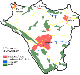
English: Land utilization in Werther (Westf.)
Deutsch: Flächennutzung in Werther (Westf.) |
| Date | |
| Source | Own work |
| Author | Hagar66 |
| Camera location | | View this and other nearby images on: OpenStreetMap |
|---|
_-_land_utilization.svg¶ms=052.076389_N_0008.413611_E_globe:Earth_type:camera__&language=en)
Homemade maps cannot be 100% accurate. This is especially true for topographical data that is hard to incorporate 100% correctly in such maps. You are free to use the map as a starting point for your new improved versions.
Licensing edit
_-_land_utilization.svg&action=edit§ion=2)
| I, the copyright holder of this work, release this work into the public domain. This applies worldwide. In some countries this may not be legally possible; if so: I grant anyone the right to use this work for any purpose, without any conditions, unless such conditions are required by law. |
File history
Click on a date/time to view the file as it appeared at that time.
| Date/Time | Thumbnail | Dimensions | User | Comment | |
|---|---|---|---|---|---|
| current | 15:37, 6 January 2009 | | 860 × 807 (277 KB) | Hagar66 (talk | contribs) | {{Information |Description={{en|1=Land utilization in Werther (Westf.)}} {{de|1=Flächennutzung in Werther (Westf.)}} |Source=Eigenes Werk (own work) |Author=Hagar66 |Date=6. January 2008 |
You cannot overwrite this file.
File usage on Commons
The following page uses this file:
File usage on other wikis
The following other wikis use this file:
- Usage on azb.wikipedia.org
- Usage on de.wikipedia.org
- Usage on ja.wikipedia.org
- Usage on nl.wikipedia.org
_-_land_utilization.svg&oldid=845264497)