File:Wesley Tabernacle United Methodist Church -- Galveston.jpg

Size of this preview: 621 × 599 pixels. Other resolutions: 249 × 240 pixels | 497 × 480 pixels | 796 × 768 pixels | 1,061 × 1,024 pixels | 2,122 × 2,048 pixels | 2,898 × 2,797 pixels.
Original file (2,898 × 2,797 pixels, file size: 2.41 MB, MIME type: image/jpeg)
Captions
Captions
Wesley Tabernacle United Methodist Church -- Galveston
Summary edit
| Description |
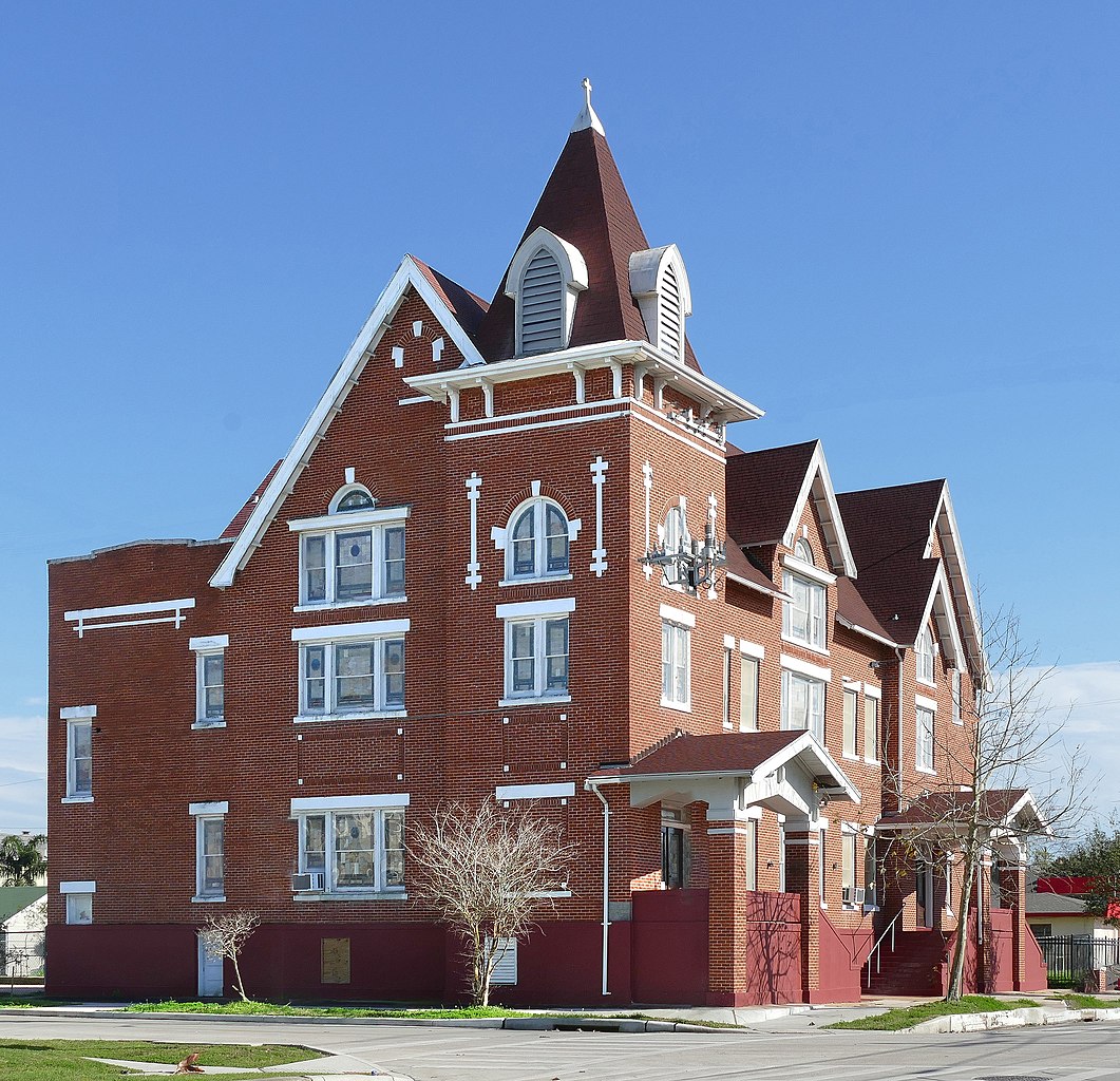
English: The African American Methodist community in Galveston dates to 1848, when Gail Borden deeded land on Broadway for a slave church. Following the Civil War, the congregation changed its affiliation from Methodist Episcopal Church, South, to the African Methodist Episcopal denomination. The church became known in 1867 as Reedy Chapel A.M.E., forerunner of A.M.E. churches throughout Texas. St. Paul M.E. Church split from Reedy Chapel, and in 1868 the St. Paul group divided, with one group buying property on Broadway and 38th Streets and becoming Wesley Tabernacle Church.
The new congregation changed locations and sanctuaries, starting with a one-room house later moved to a new site at Avenue I (Sealy) and 28th in 1870. The church added buildings later destroyed in an 1879 fire. A new wood frame sanctuary, severely damaged in the 1900 hurricane, was rebuilt by John Tankersley and an African American carpentry crew. The façade changed again in 1924 when the Galveston grade raising reached this neighborhood. Houston architectural firm Stowe and Stowe and builder Henry H. Lasden built a new red brick façade with white stone detailing. The building features a prominent corner tower, bracketed tower cap and twin bracketed porch canopies, mixing elements of Gothic Revival and Craftsman style architecture. Interior features include a unique hand-hewn structural truss system intact from renovations following the 1900 storm. Pews and altar furniture date from the 1881 sanctuary. Wesley Tabernacle United Methodist Church has long been involved in social progress for the African American community it serves. Members have promoted civil rights for many years, including organization of the first anti-lynching society in Texas in 1914. |
| Date | |
| Source | Own work |
| Author | Jim Evans |
| Camera location | | View this and other nearby images on: OpenStreetMap |
|---|
First attempt was a terrible picture. I had to shoot into the sun creating God Awful lens flare
Licensing edit
I, the copyright holder of this work, hereby publish it under the following license:
This file is licensed under the Creative Commons Attribution-Share Alike 4.0 International license.
- You are free:
- to share – to copy, distribute and transmit the work
- to remix – to adapt the work
- Under the following conditions:
- attribution – You must give appropriate credit, provide a link to the license, and indicate if changes were made. You may do so in any reasonable manner, but not in any way that suggests the licensor endorses you or your use.
- share alike – If you remix, transform, or build upon the material, you must distribute your contributions under the same or compatible license as the original.

|
This image has been assessed under the valued image criteria and is considered the most valued image on Commons within the scope: Wesley Tabernacle United Methodist Church. You can see its nomination here. |
File history
Click on a date/time to view the file as it appeared at that time.
| Date/Time | Thumbnail | Dimensions | User | Comment | |
|---|---|---|---|---|---|
| current | 23:36, 28 January 2021 | | 2,898 × 2,797 (2.41 MB) | Jim Evans (talk | contribs) | touchup |
| 19:56, 26 February 2020 |  | 2,898 × 2,797 (3.35 MB) | Jim Evans (talk | contribs) | better image | |
| 21:00, 16 December 2019 |  | 3,222 × 2,888 (3.12 MB) | Jim Evans (talk | contribs) | User created page with UploadWizard |
You cannot overwrite this file.
File usage on Commons
The following 3 pages use this file:
File usage on other wikis
The following other wikis use this file:
- Usage on en.wikipedia.org