File:Wesley United Methodist Church, Union, New York - 20221122.jpg

Size of this preview: 800 × 533 pixels. Other resolutions: 320 × 213 pixels | 640 × 427 pixels | 1,024 × 683 pixels | 1,280 × 853 pixels | 2,546 × 1,697 pixels.
Original file (2,546 × 1,697 pixels, file size: 1.91 MB, MIME type: image/jpeg)
Captions
Captions
Add a one-line explanation of what this file represents
Summary
edit
| Description |
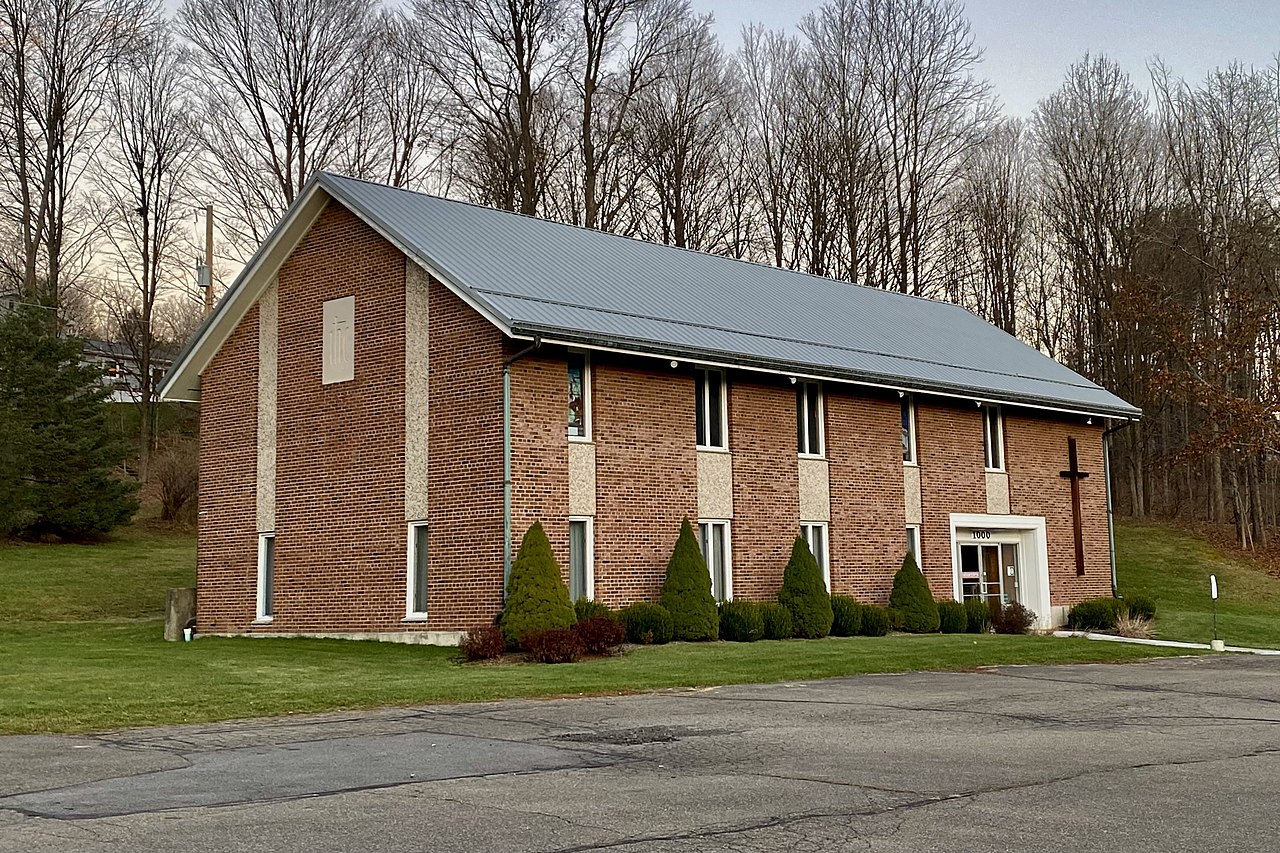
English: Wesley United Methodist Church, 1000 Day Hollow Road at Boswell Hill Road, Union, New York, November 2022. Built in 1966 to a design by Roger Patterson of the Buffalo-based architectural practice of Shelgren, Patterson & Marzec, this simple, modest yet handsome two-story side-gabled structure houses a 145-seat sanctuary, a fellowship hall, offices, and a kitchenette and is typical both of Protestant ecclesiastical architecture and of the architect's preferred aesthetic, which blends traditionalism with judiciously applied Modern touches: note the columns above the windows on the side elevations and the spandrel panels between the ones on the façade, which are both set into shallow recesses behind the main exterior walls and faced in pebbledash as a sharp color and textural contrast with the smooth-textured brown brick that comprises the rest of the façade (a similar effect is seen in Patterson's earlier design for the addition to Centenary Methodist Church in Bath, New York). It was in 1964 when Rev. George C. Kramer, Jr., pastor of the Oak Street Methodist Church in the neighboring city of Binghamton, founded this satellite church in what was then a rapidly growing suburban district about eight miles outside the city limits. There were 57 congregants at the outset who met weekly in a converted private residence, but by the time ground was broken for their permanent home just 16 months later, that number had already nearly doubled. At a cost of $82,000 financed by the Board of Missions and Church Extension of the United Methodist Church's Wyoming Conference, this was intended as only the opening salvo of what was to have been a three-stage construction project, although none of the additional proposed units were ever built. |
| Date | |
| Source | Own work |
| Author | Andre Carrotflower |
| Camera location | | View this and other nearby images on: OpenStreetMap |
|---|
Licensing
edit
I, the copyright holder of this work, hereby publish it under the following license:
This file is licensed under the Creative Commons Attribution-Share Alike 4.0 International license.
- You are free:
- to share – to copy, distribute and transmit the work
- to remix – to adapt the work
- Under the following conditions:
- attribution – You must give appropriate credit, provide a link to the license, and indicate if changes were made. You may do so in any reasonable manner, but not in any way that suggests the licensor endorses you or your use.
- share alike – If you remix, transform, or build upon the material, you must distribute your contributions under the same or compatible license as the original.
File history
Click on a date/time to view the file as it appeared at that time.
| Date/Time | Thumbnail | Dimensions | User | Comment | |
|---|---|---|---|---|---|
| current | 07:51, 2 December 2022 | | 2,546 × 1,697 (1.91 MB) | Andre Carrotflower (talk | contribs) | Uploaded own work with UploadWizard |
You cannot overwrite this file.
File usage on Commons
There are no pages that use this file.