File:West Africa UN map-de.svg

Size of this PNG preview of this SVG file: 800 × 411 pixels. Other resolutions: 320 × 164 pixels | 640 × 329 pixels | 1,024 × 526 pixels | 1,280 × 657 pixels | 2,560 × 1,315 pixels | 1,406 × 722 pixels.
Original file (SVG file, nominally 1,406 × 722 pixels, file size: 835 KB)
Captions
Captions
Add a one-line explanation of what this file represents
Summary edit
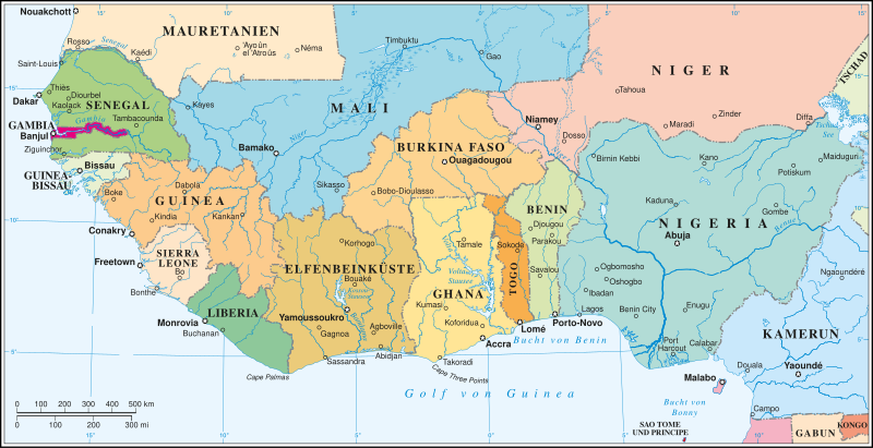
| Description |
Deutsch: Politische Karte Westafrikas.
English: Political map of West Africa. |
||
| Date | |||
| Source | |||
| Author | United Nations Cartographic Department | ||
| Permission (Reusing this file) |
I, the copyright holder of this work, hereby publish it under the following licenses:
This file is licensed under the Creative Commons Attribution-Share Alike 4.0 International license.
You may select the license of your choice. |
||
| Other versions |
|
||
| SVG development | This map was created with Adobe Illustrator. |


File history
Click on a date/time to view the file as it appeared at that time.
| Date/Time | Thumbnail | Dimensions | User | Comment | |
|---|---|---|---|---|---|
| current | 14:48, 1 April 2024 | | 1,406 × 722 (835 KB) | Furfur (talk | contribs) | neu |
| 14:45, 1 April 2024 |  | 1,406 × 722 (738 KB) | Furfur (talk | contribs) | some apparent problems with fonts ... | |
| 14:37, 1 April 2024 |  | 1,406 × 722 (739 KB) | Furfur (talk | contribs) | == {{int:filedesc}} == {{Information |Description={{User:Medium69/Traduction}} {{de|1=Politische Karte Westafrikas.}} {{en|1=Political map of West Africa.}} |Source=[http://www.un.org/Depts/Cartographic/map/profile/westafrica.pdf PDF] |Date=2024-04-01 |Author=United Nations Cartographic Department |Permission={{self|GFDL|cc-by-sa-4.0}} |Other versions=<gallery> File:Westafrica.png|<center>PNG {{Language|en}}</center> </gallery> |Other fields={{Igen|A|+|%|s=m}} }} [[Category:21st-century maps... |
You cannot overwrite this file.
File usage on Commons
The following page uses this file:
File usage on other wikis
The following other wikis use this file:
- Usage on de.wikipedia.org