File:West Clear Creek Trail (38107868715).jpg
Original file (9,485 × 3,799 pixels, file size: 20.81 MB, MIME type: image/jpeg)
Captions
Summary
editDescriptionWest Clear Creek Trail (38107868715).jpg |
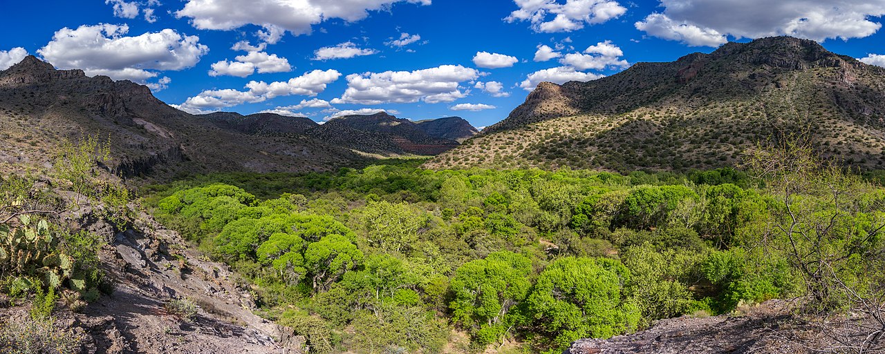
West Clear Creek Trail #17 provides the only marked and maintained access to the lower reaches of West Clear Creek Wilderness. From its western terminus at Bull Pen Ranch at the canyon mouth, the trail leads upstream into the deep, narrow gorge which medium-sized West Clear Creek has cut into the southern edge of the Colorado Plateau. The downstream end of the trail attracts large numbers of anglers, picnickers, and other streamside recreators attracted by the clear pools, slickrock water slides, and tree-shaded riparian areas tucked away between red rock canyon walls. Photo taken April 2016 by Deborah Lee Soltesz. Source: U.S. Forest Service, Coconino National Forest. Visit <a href="https://www.fs.usda.gov/recarea/coconino/recarea/?recid=55430" rel="nofollow">West Clear Creek Trail #17</a> and <a href="http://coconinonationalforest.us/" rel="nofollow">Coconino National Forest</a> for more information. |
Date | |
Source | West Clear Creek Trail |
Author | Coconino National Forest |
Camera location | 34° 32′ 19″ N, 111° 42′ 41″ W | View this and other nearby images on: OpenStreetMap | 34.538611; -111.711388 |
---|
Licensing
editThis image was originally posted to Flickr by Coconino National Forest at https://flickr.com/photos/42034606@N05/38107868715 (archive). It was reviewed on 8 September 2018 by FlickreviewR 2 and was confirmed to be licensed under the terms of the Public Domain Mark. |
8 September 2018
Public domainPublic domainfalsefalse |
This image or file is a work of a United States Department of Agriculture employee, taken or made as part of that person's official duties. As a work of the U.S. federal government, the image is in the public domain.
English ∙ español ∙ Nederlands ∙ slovenščina ∙ Tiếng Việt ∙ македонски ∙ русский ∙ українська ∙ 日本語 ∙ +/− |
File history
Click on a date/time to view the file as it appeared at that time.
Date/Time | Thumbnail | Dimensions | User | Comment | |
---|---|---|---|---|---|
current | 03:24, 8 September 2018 | 9,485 × 3,799 (20.81 MB) | Tyler ser Noche (talk | contribs) | Transferred from Flickr via #flickr2commons |
You cannot overwrite this file.
File usage on Commons
There are no pages that use this file.
Metadata
This file contains additional information such as Exif metadata which may have been added by the digital camera, scanner, or software program used to create or digitize it. If the file has been modified from its original state, some details such as the timestamp may not fully reflect those of the original file. The timestamp is only as accurate as the clock in the camera, and it may be completely wrong.
Camera manufacturer | PENTAX |
---|---|
Camera model | PENTAX K20D |
Author | Deborah Lee Soltesz |
Copyright holder |
|
Exposure time | 1/400 sec (0.0025) |
F-number | f/7.1 |
ISO speed rating | 200 |
Date and time of data generation | 15:47, 13 April 2016 |
Lens focal length | 18 mm |
Latitude | 34° 32′ 19″ N |
Longitude | 111° 42′ 41″ W |
Altitude | 1,101.334 meters above sea level |
Credit/Provider | Deborah Lee Soltesz |
Online copyright statement | https://creativecommons.org/publicdomain/zero/1.0/ |
Short title |
|
Usage terms |
|
City shown | Camp Verde |
Horizontal resolution | 300 dpi |
Vertical resolution | 300 dpi |
Software used | Adobe Photoshop Lightroom Classic 7.0 (Windows) |
File change date and time | 16:28, 11 December 2017 |
Exposure Program | Normal program |
Exif version | 2.3 |
Date and time of digitizing | 15:47, 13 April 2016 |
APEX shutter speed | 8.643856 |
APEX aperture | 5.655638 |
APEX exposure bias | 0 |
Metering mode | Center weighted average |
Flash | Flash did not fire, compulsory flash suppression |
DateTimeOriginal subseconds | 1 |
DateTimeDigitized subseconds | 1 |
Color space | sRGB |
Sensing method | One-chip color area sensor |
Custom image processing | Normal process |
Exposure mode | Auto exposure |
White balance | Manual white balance |
Focal length in 35 mm film | 27 mm |
Scene capture type | Standard |
Contrast | Hard |
Saturation | Normal |
Sharpness | Hard |
Subject distance range | Close view |
GPS tag version | 0.0.2.2 |
Lens used | smc PENTAX-DA 18-250mm F3.5-6.3 ED AL [IF] |
Date metadata was last modified | 09:28, 11 December 2017 |
Original transmission location code | WestClearCreek |
Unique ID of original document | 2EE170D6F712A140556285D4F2EC393B |
Copyright status | Copyright status not set |
Keywords |
|
Contact information | dsoltesz@fs.fed.us
http://coconinonationalforest.us 1824 S. Thompson St. Flagstaff, Arizona, 86001 |
Province or state shown | Arizona |
Country shown | United States |
Sublocation of city shown | West Clear Creek Wilderness |
Code for country shown | US |
IIM version | 4 |