File:West side line.png

Size of this preview: 257 × 600 pixels. Other resolutions: 103 × 240 pixels | 593 × 1,384 pixels.
Original file (593 × 1,384 pixels, file size: 668 KB, MIME type: image/png)
Captions
Captions
Add a one-line explanation of what this file represents
Summary
edit
| Description |
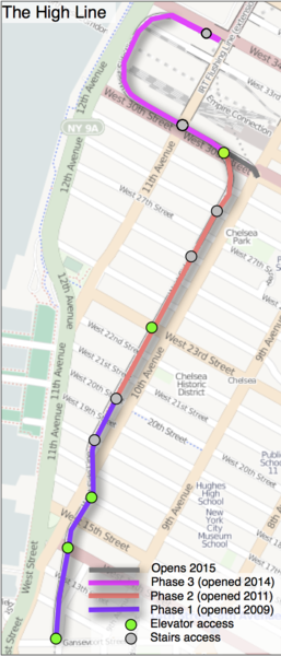
English: Map of the High Line in Manhattan, New York City |
| Date | |
| Source | Openstreetmap.org and contributors |
| Author | original image Anders Thorseth. Updated by user:PeterEastern |
Licensing
edit
This file is licensed under the Creative Commons Attribution 2.0 Generic license.
- You are free:
- to share – to copy, distribute and transmit the work
- to remix – to adapt the work
- Under the following conditions:
- attribution – You must give appropriate credit, provide a link to the license, and indicate if changes were made. You may do so in any reasonable manner, but not in any way that suggests the licensor endorses you or your use.
| Description |
This map was created from OpenStreetMap project data, collected by the community. This map may be incomplete, and may contain errors. Don't rely solely on it for navigation. |
| Date | (see file history) |
| Source | openstreetmap.org |
| Creator |
OpenStreetMap contributors |
| Permission (Reusing this file) |
OpenStreetMap data and maps are licensed under the Creative Commons Attribution-ShareAlike 2.0 license (CC-BY-SA 2.0). This file is licensed under the Creative Commons Attribution-Share Alike 2.0 Generic license.
|
| Georeferencing | If inappropriate please set warp_status = skip to hide. |
File history
Click on a date/time to view the file as it appeared at that time.
| Date/Time | Thumbnail | Dimensions | User | Comment | |
|---|---|---|---|---|---|
| current | 19:14, 20 September 2014 | | 593 × 1,384 (668 KB) | Beyond My Ken (talk | contribs) | add stairs and north end tail to 11th ave - anyone who can do this better, please do so |
| 17:35, 20 September 2014 |  | 593 × 1,384 (707 KB) | PeterEastern (talk | contribs) | hopefully the correct cropping this time! | |
| 17:21, 20 September 2014 |  | 1,239 × 1,754 (774 KB) | PeterEastern (talk | contribs) | Updated following opening of phase 3. | |
| 13:53, 3 November 2012 |  | 611 × 1,398 (525 KB) | Simon04 (talk | contribs) | Fix spacing of added parenthesis | |
| 13:47, 3 November 2012 |  | 611 × 1,398 (525 KB) | Simon04 (talk | contribs) | Added missing parenthesis | |
| 08:02, 8 October 2011 |  | 611 × 1,398 (621 KB) | PeterEastern (talk | contribs) | Added colour coding for phasing, access points and a key | |
| 09:46, 4 March 2011 |  | 284 × 662 (206 KB) | Thorseth (talk | contribs) | {{Information |Description ={{en|1=Map of the west side line in manhattan NYC}} |Source =Openstreetmap.org |Author =Anders Thorseth |Date =2011-03-04 |Permission = |other_versions = }} Category:Maps of New York City |
You cannot overwrite this file.
File usage on Commons
The following 4 pages use this file:
File usage on other wikis
The following other wikis use this file:
- Usage on ca.wikipedia.org
- Usage on en.wikipedia.org
- Usage on es.wikipedia.org
- Usage on he.wikipedia.org
- Usage on it.wikipedia.org
- Usage on www.wikidata.org