File:Western Cape topography labelled.svg

Size of this PNG preview of this SVG file: 753 × 600 pixels. Other resolutions: 301 × 240 pixels | 603 × 480 pixels | 964 × 768 pixels | 1,280 × 1,020 pixels | 2,560 × 2,040 pixels | 1,584 × 1,262 pixels.
Original file (SVG file, nominally 1,584 × 1,262 pixels, file size: 3.78 MB)
Captions
Captions
Add a one-line explanation of what this file represents
Summary edit
| Description |
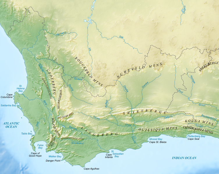
English: Topographic map, with English labels, of the Western Cape. Lambert Conformal Conic projection. |
| Date | |
| Source |
|
| Author | Htonl |
| Other versions | File:Western Cape topography.svg, File:Western Cape topography labelled (with provincial labels).svg |
.svg)
Licensing edit
I, the copyright holder of this work, hereby publish it under the following licenses:
This file is licensed under the Creative Commons Attribution-Share Alike 4.0 International license.
- You are free:
- to share – to copy, distribute and transmit the work
- to remix – to adapt the work
- Under the following conditions:
- attribution – You must give appropriate credit, provide a link to the license, and indicate if changes were made. You may do so in any reasonable manner, but not in any way that suggests the licensor endorses you or your use.
- share alike – If you remix, transform, or build upon the material, you must distribute your contributions under the same or compatible license as the original.
This file is licensed under the Creative Commons Attribution-Share Alike 3.0 Unported license.
- You are free:
- to share – to copy, distribute and transmit the work
- to remix – to adapt the work
- Under the following conditions:
- attribution – You must give appropriate credit, provide a link to the license, and indicate if changes were made. You may do so in any reasonable manner, but not in any way that suggests the licensor endorses you or your use.
- share alike – If you remix, transform, or build upon the material, you must distribute your contributions under the same or compatible license as the original.
You may select the license of your choice.
File history
Click on a date/time to view the file as it appeared at that time.
| Date/Time | Thumbnail | Dimensions | User | Comment | |
|---|---|---|---|---|---|
| current | 19:10, 11 January 2013 | | 1,584 × 1,262 (3.78 MB) | Htonl (talk | contribs) | fix label |
| 18:40, 11 January 2013 |  | 1,584 × 1,262 (3.78 MB) | Htonl (talk | contribs) | since wikipedia can't render the text properly, convert text to path | |
| 16:46, 11 January 2013 |  | 1,584 × 1,262 (3.22 MB) | Htonl (talk | contribs) | == {{int:filedesc}} == {{Information |Description ={{en|1=Topographic map, with English labeles, of the Western Cape. Lambert Conformal Conic projection.}} |Source =*Terrain data: SRTM and ETOPO1 *Feature data: VMAP0 |Au... |
You cannot overwrite this file.
File usage on Commons
The following page uses this file:
File usage on other wikis
The following other wikis use this file:
- Usage on fr.wikipedia.org
- Usage on he.wikipedia.org
- Usage on it.wikipedia.org
- Usage on pt.wikipedia.org