File:Western North America.jpg

Size of this preview: 352 × 598 pixels. Other resolutions: 141 × 240 pixels | 282 × 480 pixels | 452 × 768 pixels | 602 × 1,024 pixels | 2,059 × 3,500 pixels.
Original file (2,059 × 3,500 pixels, file size: 1.99 MB, MIME type: image/jpeg)
Captions
Captions
Add a one-line explanation of what this file represents
Summary edit
| Western North America | |
|---|---|
| Photographer |
Envisat satellite |
| Title |
Western North America |
| Description |
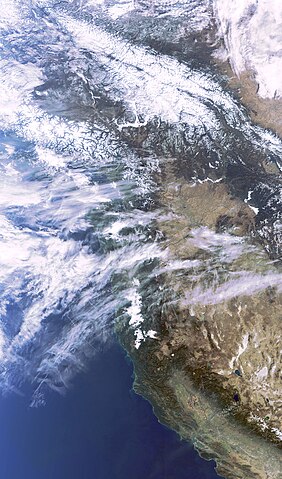
English: This image, acquired by Envisat's Medium Resolution Imaging Spectrometer (MERIS) instrument on 3 November 2009, features western North America, one of the most extensive mountainous regions on Earth. Covering more than 1200 km of the west coast, several U.S states are visible in the image, including Washington and California (from the middle of the image to bottom right hand corner).
Numerous aircraft condensation trails, or 'contrails', over northern California and southern Oregon (above California) indicate heavy air traffic over the area. |
| Depicted place | Western United States |
| Date | 3 November 2009 |
| Collection | European Space Agency |
| Accession number |
227889 |
| Credit line | ESA |
| Source | http://www.esa.int/spaceinimages/Images/2009/11/Western_North_America |
Licensing edit
This file is licensed under the Creative Commons Attribution-ShareAlike 3.0 IGO license.
- You are free:
- to share – to copy, distribute and transmit the work
- to remix – to adapt the work
- Under the following conditions:
- attribution – You must give appropriate credit, provide a link to the license, and indicate if changes were made. You may do so in any reasonable manner, but not in any way that suggests the licensor endorses you or your use.
- share alike – If you remix, transform, or build upon the material, you must distribute your contributions under the same or compatible license as the original.
File history
Click on a date/time to view the file as it appeared at that time.
| Date/Time | Thumbnail | Dimensions | User | Comment | |
|---|---|---|---|---|---|
| current | 10:16, 27 February 2017 | | 2,059 × 3,500 (1.99 MB) | Revent (talk | contribs) | =={{int:filedesc}}== {{Photograph |photographer = Envisat satellite |title = Western North America |description = {{en|1=This image, acquired by Envisat's Medium Resolution Imaging Spectrometer (MERIS) instrument on 3 Novem... |
You cannot overwrite this file.
File usage on Commons
The following 3 pages use this file:
File usage on other wikis
The following other wikis use this file:
- Usage on en.wikipedia.org