File:Western Pakistan ESA19406835.jpeg

Original file (10,980 × 7,969 pixels, file size: 11.97 MB, MIME type: image/jpeg)
Captions
Captions
Summary edit
| Warning | The original file is very high-resolution. It might not load properly or could cause your browser to freeze when opened at full size. |
|---|
| Description |
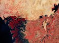
English: Captured on 14 April 2018 by the Copernicus Sentinel-2A satellite, this image shows western Pakistan and an important wetland area. The image depicts the fragmented coast, part of the Indus River Delta. A river delta forms when sediment carried from the river enters a stagnant body of water, creating an alluvial fan, which in this case extends 150 km along the coastline. The Indus River, visible on the right, veers through the Sindh Province and is one of the longest rivers in the world, rising in Tibet and flowing around 3000 km before emptying into the Arabian Sea. The Indus Delta consists of creeks, swamps, marshes and the seventh largest mangrove forest in the world. However, owing to major irrigation works and dams built on the river, as well as low rainfall, the amount of silt discharged into the sea has reduced, affecting the mangrove and local community significantly. A huge proportion of the delta has been lost and the survival of the delta freshwater species, including the Indus river dolphin, are at risk. Also responsible for pollution is the port city of Karachi, which is partially visible in the top left of the image. To the top right, there are two important bodies of water on the edge of the stony desert, both of which are also wildlife sanctuaries. The artificial, square-shaped Haleji Lake, was expanded in World War II, for the use of additional water for the troops. The freshwater lake supports an abundance of aquatic vegetation, and is home to a number of species of birds. To the far right, the freshwater Keenjhar Lake is a major source of drinking water for Karachi, as well as for Thatta, which is to the right of the yellow-beige patch of land. Both lakes, as well as the River Indus Delta, are sites of wetland designated to be of international importance under the Ramsar Convention – an international treaty for the conservation and sustainable use of wetlands. Copernicus Sentinel-2 is a two-satellite mission. Each satellite carries a high-resolution camera that images Earth’s surface in 13 spectral bands. The mission is mostly used to track changes in the way land is being used and to monitor the health of our vegetation. The vegetation in this false-colour image appears in red. This image is also featured on the Earth from Space video programme. |
| Date | 24 May 2019 (upload date) |
| Source | Western Pakistan |
| Author | European Space Agency |
| Other versions |
|
| Activity | Observing the Earth |
| Mission | Sentinel-2 |
| Set | Earth observation image of the week |
| System | Copernicus |
Licensing edit

|
This image contains data from a satellite in the Copernicus Programme, such as Sentinel-1, Sentinel-2 or Sentinel-3. Attribution is required when using this image.
Attribution: Contains modified Copernicus Sentinel data 2018
The use of Copernicus Sentinel Data is regulated under EU law (Commission Delegated Regulation (EU) No 1159/2013 and Regulation (EU) No 377/2014). Relevant excerpts:
Free access shall be given to GMES dedicated data [...] made available through GMES dissemination platforms [...].
Access to GMES dedicated data [...] shall be given for the purpose of the following use in so far as it is lawful:
GMES dedicated data [...] may be used worldwide without limitations in time.
GMES dedicated data and GMES service information are provided to users without any express or implied warranty, including as regards quality and suitability for any purpose. |
This media was created by the European Space Agency (ESA).
Where expressly so stated, images or videos are covered by the Creative Commons Attribution-ShareAlike 3.0 IGO (CC BY-SA 3.0 IGO) licence, ESA being an Intergovernmental Organisation (IGO), as defined by the CC BY-SA 3.0 IGO licence. The user is allowed under the terms and conditions of the CC BY-SA 3.0 IGO license to Reproduce, Distribute and Publicly Perform the ESA images and videos released under CC BY-SA 3.0 IGO licence and the Adaptations thereof, without further explicit permission being necessary, for as long as the user complies with the conditions and restrictions set forth in the CC BY-SA 3.0 IGO licence, these including that:
See the ESA Creative Commons copyright notice for complete information, and this article for additional details.
|
 | |
This file is licensed under the Creative Commons Attribution-ShareAlike 3.0 IGO license. Attribution: ESA, CC BY-SA IGO 3.0
| ||
File history
Click on a date/time to view the file as it appeared at that time.
| Date/Time | Thumbnail | Dimensions | User | Comment | |
|---|---|---|---|---|---|
| current | 10:18, 10 June 2020 | | 10,980 × 7,969 (11.97 MB) | OptimusPrimeBot (talk | contribs) | #Spacemedia - Upload of https://www.esa.int/var/esa/storage/images/esa_multimedia/images/2019/05/western_pakistan/19406825-1-eng-GB/Western_Pakistan.jpg via Commons:Spacemedia |
You cannot overwrite this file.
File usage on Commons
The following page uses this file: