File:Western division of Paris, Containing the Quartiers (1841), 1844 - National Library of Australia.tiff
Size of this JPG preview of this TIF file: 492 × 599 pixels. Other resolutions: 197 × 240 pixels | 394 × 480 pixels | 631 × 768 pixels | 841 × 1,024 pixels | 1,683 × 2,048 pixels | 8,272 × 10,068 pixels.
Original file (8,272 × 10,068 pixels, file size: 238.3 MB, MIME type: image/tiff)
Captions
Captions
Add a one-line explanation of what this file represents
Summary edit
| Warning | The original file is very high-resolution. It might not load properly or could cause your browser to freeze when opened at full size. |
|---|
| Title |
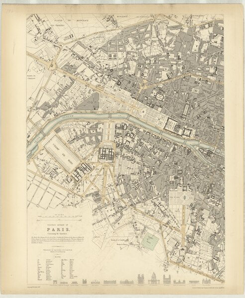
Western Division of Paris, Containing the Quartiers. [cartographic material] / J. & C. Walker, sculpt. |
|||||||||||||||||||||||
| Description |
Map of Paris in 1841. |
|||||||||||||||||||||||
| Date | ||||||||||||||||||||||||
| Source | National Library of Australia | |||||||||||||||||||||||
| Creator |
J. & C. Walker, Society for the Diffusion of Useful Knowledge |
|||||||||||||||||||||||
| Geotemporal data | ||||||||||||||||||||||||
| Date depicted | ||||||||||||||||||||||||
| Georeferencing | If inappropriate please set warp_status = skip to hide. | |||||||||||||||||||||||
| Bibliographic data | ||||||||||||||||||||||||
| Place of publication | London | |||||||||||||||||||||||
| Publisher |
Chapman and Hall |
|||||||||||||||||||||||
| Archival data | ||||||||||||||||||||||||
| Collection |
|
|||||||||||||||||||||||
| Accession number |
43457444 |
|||||||||||||||||||||||
| Medium | 1 map, cartographic material | |||||||||||||||||||||||
| Notes |
Map of the Eastern Division of Paris, showing a street plan of the city. Sketches of the principal buildings are also shown. Plate 197 from: Maps of the Society for the Diffusion of Useful Knowledge. London : Chapman and Hall, 1844. Imprint on map: London : Published under the superintendence of the Society for the Diffusion of Useful Knowledge ; Charles Knight & Co., no. 22 Ludgate Street. |
|||||||||||||||||||||||

Licensing edit
|
This work is in the public domain in its country of origin and other countries and areas where the copyright term is the author's life plus 100 years or fewer. | |
| This file has been identified as being free of known restrictions under copyright law, including all related and neighboring rights. | |
File history
Click on a date/time to view the file as it appeared at that time.
| Date/Time | Thumbnail | Dimensions | User | Comment | |
|---|---|---|---|---|---|
| current | 09:09, 18 September 2021 |  | 8,272 × 10,068 (238.3 MB) | Paris 16 (talk | contribs) | Uploaded own work with UploadWizard |
You cannot overwrite this file.
File usage on Commons
The following 4 pages use this file:
- File:Eastern Division of Paris, Containing the Quartiers (1841), 1844 - National Library of Australia.tiff (file redirect)
- File:Nla.obj-2881549222.tif (file redirect)
- File:Paris, Containing the Quartiers (1841), 1844 - National Library of Australia.jpg
- File:Paris, Containing the Quartiers (1841), 1844 - National Library of Australia.tiff
,_1844_-_National_Library_of_Australia.jpg)