File:Westfaelische bucht landsat.png
Size of this preview: 800 × 583 pixels. Other resolutions: 320 × 233 pixels | 640 × 466 pixels | 804 × 586 pixels.
Original file (804 × 586 pixels, file size: 884 KB, MIME type: image/png)
Captions
Captions
Add a one-line explanation of what this file represents
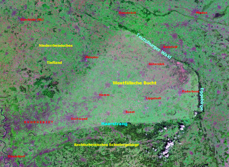
Westphalian Bay / Westfälische Bucht, Germany.
Based on Landsat photo circa 2000. Source: https://zulu.ssc.nasa.gov/mrsid/mrsid.pl archive copy at the Wayback Machine, edited by Christian Koehn (Fragwürdig)
Date: May 2005
| This file is in the public domain in the United States because it was solely created by NASA. NASA copyright policy states that "NASA material is not protected by copyright unless noted". (See Template:PD-USGov, NASA copyright policy page or JPL Image Use Policy.) | ||
 |
Warnings:
|
File history
Click on a date/time to view the file as it appeared at that time.
| Date/Time | Thumbnail | Dimensions | User | Comment | |
|---|---|---|---|---|---|
| current | 11:23, 15 May 2005 | | 804 × 586 (884 KB) | Fragwürdig (talk | contribs) | '''Westphalian Bay''' / '''Westfälische Bucht''', Germany. Based on Landsat photo circa 2000. Source: https://zulu.ssc.nasa.gov/mrsid/mrsid.pl, edited by Christian Koehn (''Fragwürdig'') Date: May 2005 {{PD-USGov}} [[Category:Geo |
You cannot overwrite this file.
File usage on Commons
There are no pages that use this file.
File usage on other wikis
The following other wikis use this file:
- Usage on de.wikipedia.org
- Usage on fa.wikipedia.org