File:Weston-Super-Mare 2nd railway station (site), Somerset (geograph 4336755).jpg
Size of this preview: 800 × 572 pixels. Other resolutions: 320 × 229 pixels | 640 × 458 pixels | 1,024 × 732 pixels | 1,280 × 915 pixels | 1,600 × 1,144 pixels.
Original file (1,600 × 1,144 pixels, file size: 377 KB, MIME type: image/jpeg)
Captions
Captions
Add a one-line explanation of what this file represents
Summary
edit,_Somerset_(geograph_4336755).jpg&action=edit§ion=1)
| Description |
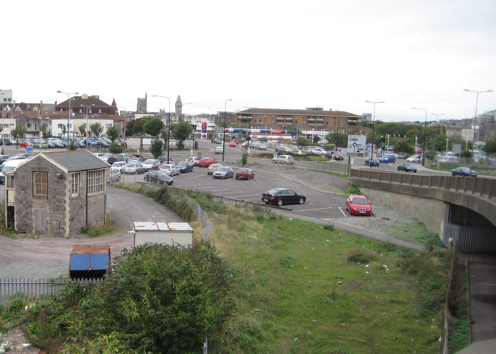
English: Weston-Super-Mare 2nd railway station (site), Somerset Opened in 1866 by the Bristol & Exeter Railway, soon to become part of the Great Western Railway empire, this terminus station replaced an earlier 1841 station slightly to the north. View west from the former station throat, past the 1866 signal box towards the terminus, which lay where the car park and supermarket appear in this image. Weston-Super-Mare's 1st railway station (1841-1866), also a small terminus, was located where the trees now are, just to the right of the supermarket. The modern station is immediately to our left, out of shot. |
| Date | |
| Source | From geograph.org.uk |
| Author | Nigel Thompson |
| Permission (Reusing this file) |
Creative Commons Attribution Share-alike license 2.0 |
| Attribution (required by the license) | Nigel Thompson / Weston-Super-Mare 2nd railway station (site), Somerset / |
| Camera location | | View this and other nearby images on: OpenStreetMap |
|---|
,_Somerset_(geograph_4336755).jpg¶ms=051.345136_N_-002.970675_E_globe:Earth_type:camera_source:geograph-osgb36(ST32496112)_heading:270.00&language=en)
| Object location | | View this and other nearby images on: OpenStreetMap |
|---|
,_Somerset_(geograph_4336755).jpg¶ms=051.345220_N_-002.971680_E_globe:Earth_class:object_type:object_source:geograph-osgb36(ST32426113)_heading:270.00&language=en)
Licensing
edit,_Somerset_(geograph_4336755).jpg&action=edit§ion=2)

|
This image was taken from the Geograph project collection. See this photograph's page on the Geograph website for the photographer's contact details. The copyright on this image is owned by Nigel Thompson and is licensed for reuse under the Creative Commons Attribution-ShareAlike 2.0 license.
|
This file is licensed under the Creative Commons Attribution-Share Alike 2.0 Generic license.
Attribution: Nigel Thompson
- You are free:
- to share – to copy, distribute and transmit the work
- to remix – to adapt the work
- Under the following conditions:
- attribution – You must give appropriate credit, provide a link to the license, and indicate if changes were made. You may do so in any reasonable manner, but not in any way that suggests the licensor endorses you or your use.
- share alike – If you remix, transform, or build upon the material, you must distribute your contributions under the same or compatible license as the original.
File history
Click on a date/time to view the file as it appeared at that time.
| Date/Time | Thumbnail | Dimensions | User | Comment | |
|---|---|---|---|---|---|
| current | 11:39, 26 December 2019 | | 1,600 × 1,144 (377 KB) | Lamberhurst (talk | contribs) | Transferred from geograph.co.uk using [https://tools.wmflabs.org/geograph2commons/ geograph2commons] |
You cannot overwrite this file.
File usage on Commons
The following page uses this file:
,_Somerset_(geograph_4336755).jpg&oldid=547136889)