File:Wheeler Geologic Area (36249616404).jpg

Original file (9,356 × 4,680 pixels, file size: 25.23 MB, MIME type: image/jpeg)
Captions
Captions
Summary
edit.jpg&action=edit§ion=1)
| Description |
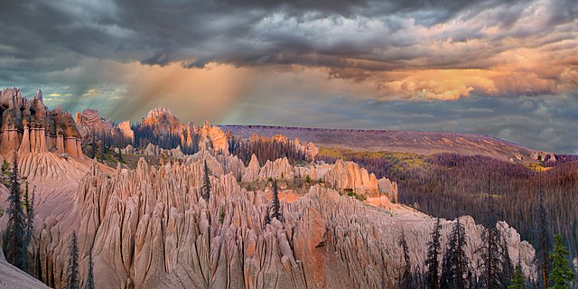
The Wheeler Geologic Area was one Colorado’s first National Monuments. It is located in the La Garita Wilderness, a few miles east of Creede, Colorado. Due to its remoteness, there were not many visitors, and its status as a National Monument was withdrawn in the 1950s. To get there, you drive up state road 149 from South Fork for about 15 miles. Just as the highway crosses over the Rio Grande, take a well-maintained dirt road to the east. This road climbs for about ten miles to the trail head. There is a pit toilet and lots of room for parking. Because it was Labor Day weekend, there were about 15 cars parked when I arrived in the afternoon. I spent the night there. From this point you can take the eight mile (one-way) hike over undulating terrain, or you can drive 14 miles over a very difficult 4WD hi-clearance road. Conventional wisdom is that the drive will take you about as long as the hike. The next morning, after eating my boiled eggs, I filled my day pack with a poncho, some snacks, and my Sterilite water purifier, and set off on the trail. I took my little Sony Cybershot RX100-iii point-and-shoot camera and a light-weight tripod. It was obvious from the start that it would be a slow walk. At 11,000 feet of elevation, any uphill walking got me out of breath fast. I was passed by several people along the way. After about 5.5 miles the trail joins the aforementioned road. The road eventually ends in a parking area that is a little less than a mile from the Wheeler area. There were several stands of Aspen with bright yellow leaves along the final path. After about three and a half hours I reached the viewing area. It was an impressive experience. I spent about an hour taking pictures and then turned around for the eight mile walk back to my truck. I arrived, exhausted and a bit unsteady, a little before 5 pm. All of the pictures I had taken were during mid-day, when the shadows are not the best for photography. So I got the idea that if I drove fast I would have time for to take the 14-mile drive back to the area and get there before sunset. I drove like a crazy person (which I was a little bit) and made the trip in an hour and 15 minutes, putting a few scars on the truck body in the process. Just as I arrived, it began to rain, but after a few minutes it abated. I had about 20 minutes to walk up the last part of the trail if I wanted to reach the top before sunset. I made it! Just as the sun was setting, I hastily set up my little Sony on the tripod and clicked off a few shots. It was darker than you would think from the image here. Thank you, Photoshop!! I walked back down in the dark to my truck and slept there at the end of the road. The next morning I made the bumpy 14 mile drive back down to the trailhead. I stopped there to take a break. Actually, as I pulled in, the truck engine quit and so did the radio. It was totally dead. I popped the hood and saw that the battery had bounced out of place and the cable had become unattached. I looked in my toolkit and found everything but what I needed (a crescent wrench). I worked the connector back onto the battery by hand, and that turned out to be good enough. The truck started and I was on my way home. |
| Date | |
| Source | Wheeler Geologic Area |
| Author | John Fowler from Placitas, NM, USA |
| Camera location | | View this and other nearby images on: OpenStreetMap |
|---|
.jpg¶ms=037.879486_N_-106.786186_E_globe:Earth_type:camera_source:Flickr_&language=en)
Licensing
edit.jpg&action=edit§ion=2)
- You are free:
- to share – to copy, distribute and transmit the work
- to remix – to adapt the work
- Under the following conditions:
- attribution – You must give appropriate credit, provide a link to the license, and indicate if changes were made. You may do so in any reasonable manner, but not in any way that suggests the licensor endorses you or your use.
| This image was originally posted to Flickr by snowpeak at https://flickr.com/photos/53986933@N00/36249616404 (archive). It was reviewed on 23 November 2017 by FlickreviewR 2 and was confirmed to be licensed under the terms of the cc-by-2.0. |
File history
Click on a date/time to view the file as it appeared at that time.
| Date/Time | Thumbnail | Dimensions | User | Comment | |
|---|---|---|---|---|---|
| current | 21:30, 23 November 2017 | | 9,356 × 4,680 (25.23 MB) | Aspargos (talk | contribs) | Transferred from Flickr via Flickr2Commons |
You cannot overwrite this file.
File usage on Commons
There are no pages that use this file.
.jpg&oldid=894786784)