File:Wielichowo (gmina) location map.png
Size of this preview: 522 × 599 pixels. Other resolutions: 209 × 240 pixels | 418 × 480 pixels | 647 × 743 pixels.
Original file (647 × 743 pixels, file size: 59 KB, MIME type: image/png)
Captions
Captions
Add a one-line explanation of what this file represents
| Description |
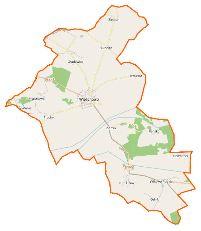
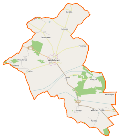
Polski: Mapa gminy Wielichowo, Polska
English: Map of Gmina Wielichowo, Poland |
|||||||||
| Date | ||||||||||
| Source | You may find a page on the OpenStreetMap wiki page for Wielichowo (gmina) | |||||||||
| Creator |
OpenStreetMap contributors OpenStreetMap contributors |
|||||||||
| Permission (Reusing this file) |
OpenStreetMap data is available under the Open Database License (details). Map tiles are licensed under the Creative Commons Attribution-ShareAlike 2.0 license (CC-BY-SA 2.0).
This file is licensed under the Creative Commons Attribution-Share Alike 2.0 Generic license.
|
|||||||||
| Geotemporal data | ||||||||||
| Bounding box |
|
|||||||||
| Georeferencing | If inappropriate please set warp_status = skip to hide. | |||||||||
File history
Click on a date/time to view the file as it appeared at that time.
| Date/Time | Thumbnail | Dimensions | User | Comment | |
|---|---|---|---|---|---|
| current | 07:41, 2 December 2014 | | 647 × 743 (59 KB) | VanWiel (talk | contribs) | {{OpenStreetMap | name = Wielichowo (gmina) | location = Wielichowo (gmina) | description = {{pl|Mapa gminy Wielichowo, Polska}} {{en|Map of Gmina Wielichowo, Poland}} | top = 52.1853 | bottom = 52.... |
You cannot overwrite this file.
File usage on Commons
There are no pages that use this file.
File usage on other wikis
The following other wikis use this file:
- Usage on de.wikipedia.org
- Usage on fr.wikipedia.org
- Usage on pl.wikipedia.org
- Wielichowo
- Wielichowo (gmina)
- Gradowice
- Piotrowo Wielkie
- Śniaty (województwo wielkopolskie)
- Wielichowo-Wieś
- Wilkowo Polskie
- Ziemin (wieś)
- Łubnica (województwo wielkopolskie)
- Pruszkowo (województwo wielkopolskie)
- Reńsko (województwo wielkopolskie)
- Zielęcin (województwo wielkopolskie)
- Augustowo (powiat grodziski)
- Dębsko (powiat grodziski)
- Prochy (wieś w powiecie grodziskim)
- Trzcinica (powiat grodziski)
- Celinki (Wilkowo Polskie)
- Helenopol (Wilkowo Polskie)
- Borek (Dębsko)
- Mokrzec (powiat grodziski)
- Pawłówko (Wielichowo-Wieś)
- Wielichowo (stacja kolejowa)
- Parafia św. Marii Magdaleny w Wielichowie
- Wielichowo Zachód
- Wilkowo Polskie (przystanek kolejowy)
- Śniaty (przystanek kolejowy)
- Ziemin (przystanek kolejowy)
- Kościół św. Marii Magdaleny w Wielichowie
- Dębsko (przystanek kolejowy)
- Łubnica (stacja kolejowa)
- Gradowice (stacja kolejowa)
- Ziemin (osada leśna)
- Prochy (osada leśna w powiecie grodziskim)
- Kościół św. Klemensa w Zielęcinie
- Moduł:Mapa/dane/Wielichowo
- Moduł:Mapa/dane/Wielichowo (gmina)
- Kościół św. Jadwigi w Wilkowie Polskim
- Ziemińskie Góry
- Parafia św. Jadwigi w Wilkowie Polskim
- Parafia św. Mikołaja w Prochach
- Parafia św. Klemensa w Zielęcinie
- Rolniczy Kombinat Spółdzielczy Łubnica
- Kościół Narodzenia Najświętszej Maryi Panny w Wielichowie
- Kościół św. Mikołaja w Prochach
- Wielichowo-Odbudowanie
- Wielichowo Odbudowanie-Las
- Wielichowo-Probostwo
- Usage on pl.wikibooks.org
View more global usage of this file.
_location_map.png)
_location_map.png&oldid=607603433)