File:Wikiacidaliumboundaries.jpg

Size of this preview: 800 × 450 pixels. Other resolutions: 320 × 180 pixels | 640 × 360 pixels | 1,024 × 576 pixels | 1,280 × 720 pixels | 1,920 × 1,080 pixels.
Original file (1,920 × 1,080 pixels, file size: 641 KB, MIME type: image/jpeg)
Captions
Captions
Add a one-line explanation of what this file represents

Summary
edit
| Description |
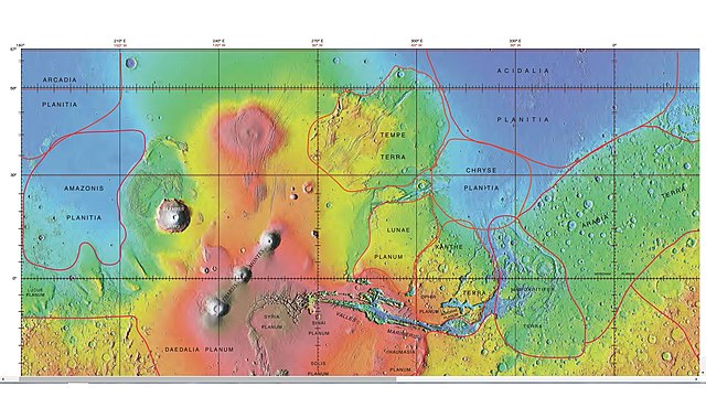
English: Mola map showing acidalium boundaries and other regions |
| Date | |
| Source | http://planetarynames.wr.usgs.gov/images/mola_regional_boundaries.pdf |
| Author | Jim Secosky modified NASA image. |
| Permission (Reusing this file) |
Caption is International Astronomical Union Working Group for Planetary System Nomenclature. "Gazetteer of Planetary Nomenclature." |
Licensing
edit
| This file is in the public domain in the United States because it was solely created by NASA. NASA copyright policy states that "NASA material is not protected by copyright unless noted". (See Template:PD-USGov, NASA copyright policy page or JPL Image Use Policy.) | ||
 |
Warnings:
|
File history
Click on a date/time to view the file as it appeared at that time.
| Date/Time | Thumbnail | Dimensions | User | Comment | |
|---|---|---|---|---|---|
| current | 16:04, 25 February 2015 | | 1,920 × 1,080 (641 KB) | Jimmarsmars (talk | contribs) | {{Information |Description ={{en|1=Mola map showing acidalium boundaries and other regions}} |Source =http://planetarynames.wr.usgs.gov/images/mola_regional_boundaries.pdf |Author =Jim Secosky modified NASA image. |Date =20... |
You cannot overwrite this file.
File usage on Commons
The following page uses this file:
File usage on other wikis
The following other wikis use this file:
- Usage on ca.wikipedia.org
- Usage on es.wikipedia.org
- Usage on fr.wikipedia.org
- Usage on hu.wikipedia.org
- Usage on it.wikipedia.org
- Usage on www.wikidata.org