File:Wildfires burning in Alberta, Canada (MODIS 2019-05-23).jpg

Original file (3,626 × 2,827 pixels, file size: 2.57 MB, MIME type: image/jpeg)
Captions
Captions
Summary
edit.jpg&action=edit§ion=1)
| Description |
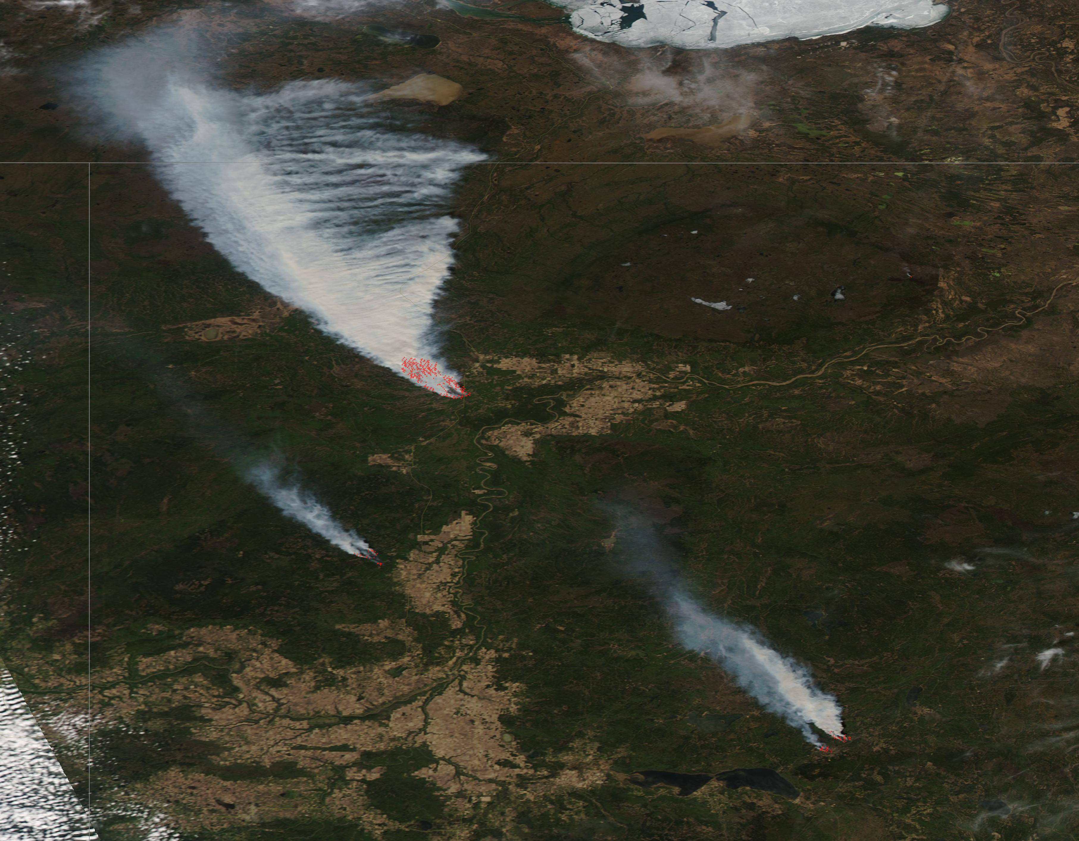
English: On May 22, 2019, more than 5,000 residents had been evacuated from the town of High Level, Dene Tha’ First Nation communities, and other locations near a vicious fire raging in northern Alberta, Canada.
The Chuckegg Creek wildfire started on May 12, 2019, and mostly burned northwest and away from populated areas. On May 18, residents told news media about thick clouds of black smoke, an ominous sign but still a distant threat. By May 19, the fire had charred at least 25,000 hectares (60,000 acres), according to statistics from provincial officials at Alberta Wildfire. On May 20, the fire took a turn and advanced within 5 kilometers (3.1 mi) of High Level (population 3,000). By May 22 the fire had consumed more than 200,000 acres and had leaped to within 3.2 km (2 mi) of the town of High Level. The fire has been reported as a 6 out of 6 on the fire intensity scale, meaning that the fire is jumping crown to crown on trees. No injuries have been reported, but the government has cautioned residents that respiratory problems, such as cough, throat irritation, headache and shortness of breath are risks of inhaling smoke from the fire, especially in the very young, those who are ill, and the elderly. The Chuckegg Creek wildfire was one of more than a dozen wildfires burning in Alberta Province as of May 22, 2019. The provincial government recorded 4 fires as being under control and 12 as “being held” (not likely to grow past expected boundaries). Fire bans and off-road vehicle restrictions were in place in much of the northern tier of Alberta. The Moderate Resolution Imaging Spectroradiometer (MODIS) on board NASA’s Aqua satellite acquired a true-color image of fires burning in northern Alberta on May 19, 2019. The northernmost fire is the Chuckegg Creek fire. The fires have sprung up in a time that ecologists refer to as the “spring dip.” Scientists have noted for years that forests in Canada and around the Great Lakes in the United States are especially susceptible to fire in the late spring because trees and grasses reach a point of extremely low moisture content (a dip) between the end of winter and the start of new seasonal growth. The effect is not yet well understood, as it also involves subtle changes in plant chemistry. |
||
| Date | Taken on 19 May 2019 | ||
| Source |
Wildfires burning in Alberta, Canada (direct link)
|
||
| Author | MODIS Land Rapid Response Team, NASA GSFC |
| This media is a product of the Aqua mission Credit and attribution belongs to the mission team, if not already specified in the "author" row |
Licensing
edit.jpg&action=edit§ion=2)
| This file is in the public domain in the United States because it was solely created by NASA. NASA copyright policy states that "NASA material is not protected by copyright unless noted". (See Template:PD-USGov, NASA copyright policy page or JPL Image Use Policy.) | ||
 |
Warnings:
|
File history
Click on a date/time to view the file as it appeared at that time.
| Date/Time | Thumbnail | Dimensions | User | Comment | |
|---|---|---|---|---|---|
| current | 03:19, 17 February 2024 | | 3,626 × 2,827 (2.57 MB) | OptimusPrimeBot (talk | contribs) | #Spacemedia - Upload of http://modis.gsfc.nasa.gov/gallery/images/image05232019_250m.jpg via Commons:Spacemedia |
You cannot overwrite this file.
File usage on Commons
There are no pages that use this file.
.jpg&oldid=852772942)