File:Wildfires in Western Canada (MODIS).jpg
Original file (5,094 × 3,854 pixels, file size: 2.63 MB, MIME type: image/jpeg)
Captions
Captions
Summary
edit.jpg&action=edit§ion=1)
| Description |
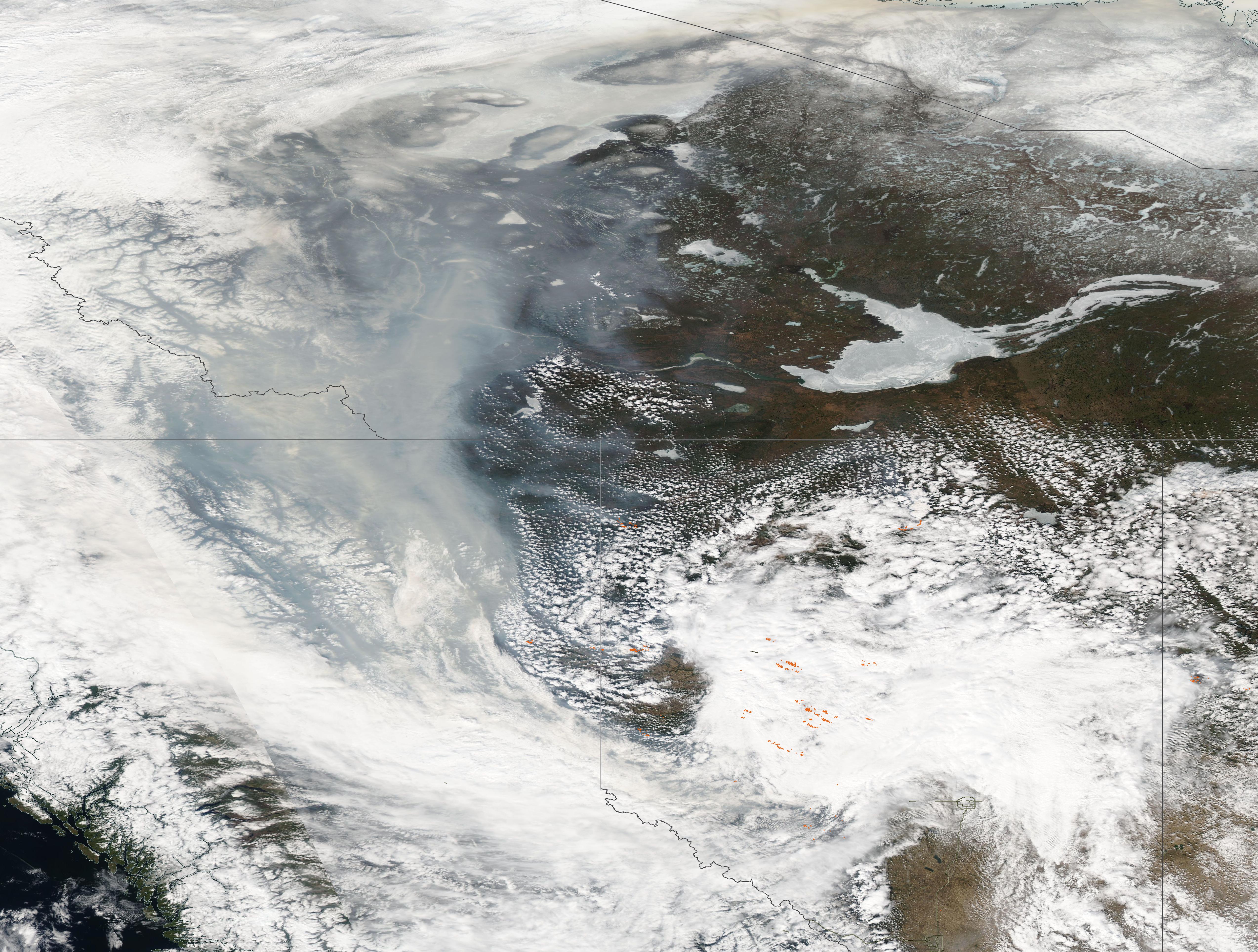
English: More than 100 wildland fires raged across Western Canada in early May 2023, forcing an estimated 30,000 people in Alberta and British Columbia to evacuate. The fires destroyed homes and produced chimneys of smoke that reached into the upper troposphere.
The extensive and dangerous fires moving across Canada’s richest oil region also forced shutdowns of several oil production facilities. As of May 8, energy producers were estimated to be holding back an estimated 280,000 barrels of oil equivalent each day, or roughly 3 percent of the country’s output. The Moderate Resolution Imaging Spectroradiometer (MODIS) on board NASA’s Aqua satellite acquired a true-color image of smoke billowing from fires in the two Canadian provinces on May 7, 2023, the day after officials in Alberta declared a provincial state of emergency. A large cluster of red hot spots, each marking actively burning fire, can be seen in Alberta, despite heavy cloud cover. Massive thick smoke covers British Columbia and blows northwest over parts of Yukon and the Northwest Territories. The Great Slave Lake, located in Northwest Territories, remains covered in ice. As of the evening of May 8, there were 88 fires burning in Alberta, with 29 remaining out of control in Alberta, according to the Alberta Wildfire Status Dashboard. Fourteen of these fires were listed as “Fires of Note”, which is defined as a fire determined to be of significant public interest and which may pose a threat to public safety, communities, or critical infrastructure. On that same day, four fires were burning out of control in British Columbia, near its border with Alberta. The fires in Alberta have been so intense they have produced towering chimneys of smoke. Using remote sensing, researchers at the Cooperative Institute for Meteorological Satellite Studies at the University of Wisconsin, Madison, observed the formation of a pyrocumulonimbus (pyroCb) cloud billowing from a wildfire west of Edmonton on May 4. Temperatures at the top of the cloud were estimated to have reached -61°C (-78°F), which indicates that the smoke may have reached an altitude of about 12 kilometers (39,000 feet). That would put the top of the pyroCb cloud into the tropopause—the boundary between the troposphere and the stratosphere. |
||
| Date | Taken on 7 May 2023 | ||
| Source |
Wildfires in Western Canada (direct link)
|
||
| Author | MODIS Land Rapid Response Team, NASA GSFC |
| This media is a product of the Aqua mission Credit and attribution belongs to the mission team, if not already specified in the "author" row |
Licensing
edit.jpg&action=edit§ion=2)
| This file is in the public domain in the United States because it was solely created by NASA. NASA copyright policy states that "NASA material is not protected by copyright unless noted". (See Template:PD-USGov, NASA copyright policy page or JPL Image Use Policy.) | ||
 |
Warnings:
|
File history
Click on a date/time to view the file as it appeared at that time.
| Date/Time | Thumbnail | Dimensions | User | Comment | |
|---|---|---|---|---|---|
| current | 19:57, 31 July 2023 | | 5,094 × 3,854 (2.63 MB) | OptimusPrimeBot (talk | contribs) | #Spacemedia - Upload of http://modis.gsfc.nasa.gov/gallery/images/image05092023_500m.jpg via Commons:Spacemedia |
You cannot overwrite this file.
File usage on Commons
There are no pages that use this file.
.jpg&oldid=788811962)