File:Willem-Alexanderboom, Máximapark 01.jpg
Size of this preview: 448 × 599 pixels. Other resolutions: 179 × 240 pixels | 359 × 480 pixels | 575 × 768 pixels | 766 × 1,024 pixels | 2,339 × 3,126 pixels.
Original file (2,339 × 3,126 pixels, file size: 5.19 MB, MIME type: image/jpeg)
File information
Structured data
Captions
Summary
editDescriptionWillem-Alexanderboom, Máximapark 01.jpg |
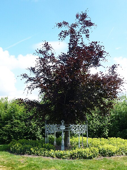
Nederlands: Willem-Alexanderboom, Máximapark. Deze kroningsboom, een rode beuk is geplant in 2013 ter gelegenheid van de kroning van Willem-Alexander. Het sierhek, de boombeschermer, is gemaakt door Margot Bergman. Onthuld op 21 juni 2013 door burgemeester dr. A. Wolfsen |
Date | |
Source | Own work |
Author | Agaath |
Camera location | 52° 05′ 46.67″ N, 5° 01′ 28.98″ E | View this and other nearby images on: OpenStreetMap | 52.096297; 5.024717 |
---|
Licensing
editI, the copyright holder of this work, hereby publish it under the following license:
This file is licensed under the Creative Commons Attribution-Share Alike 4.0 International license.
- You are free:
- to share – to copy, distribute and transmit the work
- to remix – to adapt the work
- Under the following conditions:
- attribution – You must give appropriate credit, provide a link to the license, and indicate if changes were made. You may do so in any reasonable manner, but not in any way that suggests the licensor endorses you or your use.
- share alike – If you remix, transform, or build upon the material, you must distribute your contributions under the same or compatible license as the original.
File history
Click on a date/time to view the file as it appeared at that time.
Date/Time | Thumbnail | Dimensions | User | Comment | |
---|---|---|---|---|---|
current | 21:47, 5 June 2023 | 2,339 × 3,126 (5.19 MB) | Agaath (talk | contribs) | Uploaded own work with UploadWizard |
You cannot overwrite this file.
File usage on Commons
The following 2 pages use this file:
Metadata
This file contains additional information such as Exif metadata which may have been added by the digital camera, scanner, or software program used to create or digitize it. If the file has been modified from its original state, some details such as the timestamp may not fully reflect those of the original file. The timestamp is only as accurate as the clock in the camera, and it may be completely wrong.
Camera manufacturer | Panasonic |
---|---|
Camera model | DMC-TZ20 |
Exposure time | 1/500 sec (0.002) |
F-number | f/4 |
ISO speed rating | 100 |
Date and time of data generation | 12:51, 31 May 2017 |
Lens focal length | 5 mm |
Latitude | 52° 5′ 46.67″ N |
Longitude | 5° 1′ 28.98″ E |
Width | 2,432 px |
Height | 4,320 px |
Bits per component |
|
Pixel composition | RGB |
Orientation | Normal |
Number of components | 3 |
Horizontal resolution | 180 dpi |
Vertical resolution | 180 dpi |
Software used | Adobe Photoshop Elements 12.0 Windows |
File change date and time | 13:37, 3 June 2023 |
Y and C positioning | Co-sited |
Exposure Program | Landscape mode (for landscape photos with the background in focus) |
Exif version | 2.3 |
Date and time of digitizing | 12:51, 31 May 2017 |
Meaning of each component |
|
Image compression mode | 4 |
APEX shutter speed | 8.965784 |
APEX aperture | 4 |
APEX exposure bias | 0 |
Maximum land aperture | 3.6171875 APEX (f/3.5) |
Metering mode | Pattern |
Light source | Unknown |
Flash | Flash did not fire, compulsory flash suppression |
Supported Flashpix version | 1 |
Color space | sRGB |
Sensing method | One-chip color area sensor |
File source | Digital still camera |
Scene type | A directly photographed image |
Custom image processing | Normal process |
Exposure mode | Auto exposure |
White balance | Auto white balance |
Digital zoom ratio | 0 |
Focal length in 35 mm film | 31 mm |
Scene capture type | Standard |
Scene control | None |
Contrast | Normal |
Saturation | Normal |
Sharpness | Normal |
GPS time (atomic clock) | 11:42 |
Satellites used for measurement | 4 |
Receiver status | Measurement in progress |
Measurement mode | 2-dimensional measurement |
Measurement precision | Fair (1.3) |
Geodetic survey data used | WGS-84 |
GPS date | 31 May 2017 |
GPS tag version | 0.0.3.2 |
Date metadata was last modified | 15:37, 3 June 2023 |
Unique ID of original document | 3094733488BEF43583DB6545F638ABC1 |