File:WinkelnGroßheide1844(PreußischeUraufnahme).jpg
Size of this preview: 800 × 450 pixels. Other resolutions: 320 × 180 pixels | 640 × 360 pixels | 1,024 × 576 pixels.
Original file (1,024 × 576 pixels, file size: 871 KB, MIME type: image/jpeg)
Captions
Captions
Add a one-line explanation of what this file represents
Summary edit
.jpg&action=edit§ion=1)
| Description |
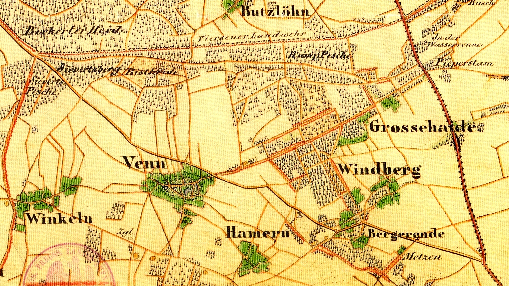
Deutsch: Topografische Karte 1:25000, Preußische Uraufnahme, Blatt 4704 (Viersen), Ausschnitt mit den Dörfern Winkeln, Venn, Hamern, Windberg und Großheide.
English: Topographic Map 1:25000 by Royal Prussian Land Survey, sheet 4704 (Viersen), snippet displaying the villages Winkeln, Venn, Hamern, Windberg and Großheide.
Nederlands: Topografische kaart 1:25000, Pruisische Oeropname, blad 4704 (Viersen), uittreksel met de dorpjes Winkeln, Venn, Hamern, Windberg en Großheide. |
| Date | |
| Source | Selbst abgescannt: Vorlage war ein vom Landesvermessungsamt NRW (heute: Geobasisdaten Land NRW), Bonn 1991 herausgegebener Nachdruck. |
| Author | von Tempelhof, Prem. Lt. im 28ten Inf. Rgmt. |
Licensing edit
.jpg&action=edit§ion=2)
|
This work is in the public domain in its country of origin and other countries and areas where the copyright term is the author's life plus 70 years or fewer. This work is in the public domain in the United States because it was published (or registered with the U.S. Copyright Office) before January 1, 1929. | |
| This file has been identified as being free of known restrictions under copyright law, including all related and neighboring rights. | |
File history
Click on a date/time to view the file as it appeared at that time.
| Date/Time | Thumbnail | Dimensions | User | Comment | |
|---|---|---|---|---|---|
| current | 21:58, 18 May 2012 | | 1,024 × 576 (871 KB) | Þomas (talk | contribs) | == {{int:filedesc}} == {{Information |Description ={{de|1=Topografische Karte 1:25000, Preußische Uraufnahme, Blatt 4704 (Viersen), Ausschnitt mit den Dörfern ''Winkeln'', ''Venn'', ''Hamern'', ''Windberg'' und ''Großheide''.}} {{en|1=Topographic... |
You cannot overwrite this file.
File usage on Commons
There are no pages that use this file.
File usage on other wikis
The following other wikis use this file:
- Usage on de.wikipedia.org
.jpg&oldid=747273890)