File:Winterthur-Wettingen.png

Size of this preview: 800 × 430 pixels. Other resolutions: 320 × 172 pixels | 640 × 344 pixels | 1,024 × 551 pixels | 1,280 × 688 pixels | 2,198 × 1,182 pixels.
Original file (2,198 × 1,182 pixels, file size: 2.83 MB, MIME type: image/png)
Captions
Captions
Add a one-line explanation of what this file represents
Summary edit
| Description |
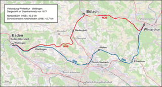
Deutsch: Karte der Verbindungen Winterthur-Wettingen der Schweizerische Nordostbahn und der Schweizerische Nationalbahn dargestellt im Eisenbahnnetz von 1877. |
| Date | |
| Source |
Own work. Längenangaben gemäss "Die Schipkapass"-Bahn Bülach - Baden in Schweizer Eisenbahn-Revue Nummern 8-9 und 10 des Jahres 2002. Map was created using: |
| Author | |
| Permission (Reusing this file) |
Map data (c) OpenStreetMap (and) contributors, CC-BY-SA |
Licensing edit
This file is licensed under the Creative Commons Attribution-Share Alike 2.0 Generic license.
- You are free:
- to share – to copy, distribute and transmit the work
- to remix – to adapt the work
- Under the following conditions:
- attribution – You must give appropriate credit, provide a link to the license, and indicate if changes were made. You may do so in any reasonable manner, but not in any way that suggests the licensor endorses you or your use.
- share alike – If you remix, transform, or build upon the material, you must distribute your contributions under the same or compatible license as the original.
File history
Click on a date/time to view the file as it appeared at that time.
| Date/Time | Thumbnail | Dimensions | User | Comment | |
|---|---|---|---|---|---|
| current | 05:04, 7 April 2015 | | 2,198 × 1,182 (2.83 MB) | Pechristener (talk | contribs) | Fehler in Legende behoben |
| 20:02, 20 September 2014 |  | 2,198 × 1,182 (2.83 MB) | Pechristener (talk | contribs) | == {{int:filedesc}} == {{Information |Description = {{de|1=Karte der Verbindungen Winterthur-Wettingen der Schweizerische Nordostbahn und der Schweizerische Nationalbahn dargeste... |
You cannot overwrite this file.
File usage on Commons
The following 5 pages use this file:
File usage on other wikis
The following other wikis use this file:
- Usage on de.wikipedia.org