File:Wisconsin Land Cession Map 1 – Close up of 242 & 243 & 245.png

Size of this preview: 600 × 600 pixels. Other resolutions: 240 × 240 pixels | 480 × 480 pixels | 768 × 768 pixels | 1,024 × 1,024 pixels | 2,300 × 2,300 pixels.
Original file (2,300 × 2,300 pixels, file size: 11.76 MB, MIME type: image/png)
Captions
Captions
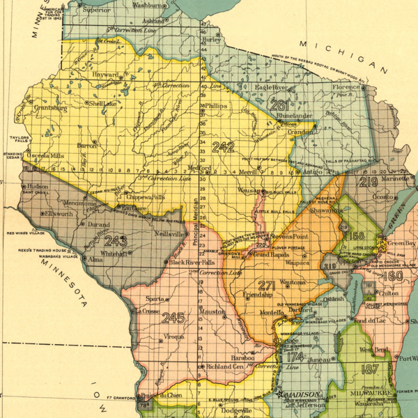
Map of Native American land cessions in Wisconsin per US Treaty with the Ojibwe, 1837 (242), Treaty with the Dakota, 1837 (243), and Treaty with the Winnebago, 1837 (245)
Summary
edit
| Description |
English: Map of lands in present-day Wisconsin ceded to the United States by Ojibwe (242), Dakota (243) and Winnebago leaders (245) in land cession treaties signed in 1837 |
| Date | |
| Source |
Indian Land Cessions in the United States, 1784-1894 United States Serial Set, Number 4015 |
| Author | Charles C. Royce |
Licensing
edit
| This work is from the Library of Congress. According to the library, there are no known copyright restrictions on the use of this work. |  |
File history
Click on a date/time to view the file as it appeared at that time.
| Date/Time | Thumbnail | Dimensions | User | Comment | |
|---|---|---|---|---|---|
| current | 17:51, 24 June 2021 | | 2,300 × 2,300 (11.76 MB) | Cielquiparle (talk | contribs) | Uploaded a work by Charles C. Royce from Indian Land Cessions in the United States, 1784-1894 United States Serial Set, Number 4015 with UploadWizard |
You cannot overwrite this file.
File usage on Commons
There are no pages that use this file.
File usage on other wikis
The following other wikis use this file:
- Usage on en.wikipedia.org