File:Wismar Fischerturm 06.jpg

Size of this preview: 424 × 599 pixels. Other resolutions: 170 × 240 pixels | 340 × 480 pixels | 544 × 768 pixels | 725 × 1,024 pixels | 1,450 × 2,048 pixels | 3,525 × 4,979 pixels.
Original file (3,525 × 4,979 pixels, file size: 7.42 MB, MIME type: image/jpeg)
Captions
Captions
Add a one-line explanation of what this file represents
Summary edit
| Description |
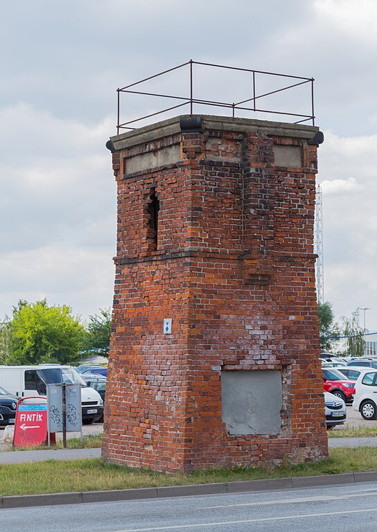
English: Fishermen's Tower (Fischerturm) in the historic city of Wismar, Landkreis Nordwestmecklenburg, Mecklenburg-Vorpommern, Germany. The brick tower is a listed cultural heritage monument.
Deutsch: Der Fischerturm (Fischerwachturm) am Alten Hafen von Wismar, Landkreis Nordwestmecklenburg, Mecklenburg-Vorpommern, Deutschland. Zwar eher unscheinbar und scheinbar deplatziert wirkend, gehört das 1870 errichtete Backsteingebäude doch neben dem bekannten Wassertor zu den wichtigsten maritimen Denkmälern in der Hansestadt Wismar. Der Turm war früher mit einem Sturmball ausgestattet, an dem die Fischer die für ihre Fangplanung wichtigen Windverhältnisse ersehen konnten. Außerdem umgab ein Schuppen den Turm, der heute zudem viel tiefer im Erdreich steckt als früher, da im Lauf der Zeit das Straßenniveau immer weiter angehoben wurde. Die Aufnahme zeigt die dem Hafen zugewandte Turmseite mit der Aussparung, in die bis vor einigen Jahren die alten Wappen des 1870 abgebrochenen Poeler Tores eingesetzt waren. Diese wurden entfernt und vorerst eingelagert. Der Fischerturm steht unter Denkmalschutz und ist Teil der UNESCO-Welterbestätte „Historische Altstädte Stralsund und Wismar“. |
| Date | Taken on 18 July 2019 |
| Source | Own work |
| Author | J.-H. Janßen |
| Camera location | | View this and other nearby images on: OpenStreetMap |
|---|
Notes edit
This image is not public domain. Please respect the copyright protection. It may only be used according to the rules mentioned here. This specifically excludes use in social media, if applicable terms of the licenses listed here not appropriate. (See for example CC BY-SA on Facebook.) Of course, a free license is no carte blanche for use. Especially there restrictions not based on the License, for example to the personality rights of the author. This is especially true for the required attribution and the use of the image. It is expressly not allowed to give the impression through the use of the image, that the author supports the work, in which the image is used, or whose rights holders in any way. |

| Please do not upload a modified image here without consultation with the author. The author would like to make possible minor modifications only at his own source. (The source is usually a RAW file. Processing of the JPEG file means a loss of quality.) This ensures that the changes and the quality are preserved. Please if you think that any changes should be required, please contact the author. Otherwise you can upload a new image with a new name. Please use one of the templates derivative or extract. Please enter your name too, if you upload a derivative or a detail, because you're in charge of the changes. Please do not rename this file. The name is part of the attribution. In the case of misstatements, the author is pleased to provide information. |
Licensing edit
I, the copyright holder of this work, hereby publish it under the following license:
This file is licensed under the Creative Commons Attribution-Share Alike 4.0 International license.
- You are free:
- to share – to copy, distribute and transmit the work
- to remix – to adapt the work
- Under the following conditions:
- attribution – You must give appropriate credit, provide a link to the license, and indicate if changes were made. You may do so in any reasonable manner, but not in any way that suggests the licensor endorses you or your use.
- share alike – If you remix, transform, or build upon the material, you must distribute your contributions under the same or compatible license as the original.

|
This image was uploaded as part of Wiki Loves Monuments 2020.
|
File history
Click on a date/time to view the file as it appeared at that time.
| Date/Time | Thumbnail | Dimensions | User | Comment | |
|---|---|---|---|---|---|
| current | 18:52, 17 September 2020 | | 3,525 × 4,979 (7.42 MB) | J.-H. Janßen (talk | contribs) | {{Information |Description ={{en|1=Fishermen's Tower (''Fischerturm'') in the historic city of Wismar, Landkreis Nordwestmecklenburg, Mecklenburg-Vorpommern, Germany. The brick tower is a listed cultural heritage monument.}} {{de|1=Der Fischerturm (Fischerwachturm) am Alten Hafen von Wismar, Landkreis Nordwestmecklenburg, Mecklenburg-Vorpommern, Deutschland. Zwar eher unscheinbar un... |
You cannot overwrite this file.
File usage on Commons
There are no pages that use this file.