File:Wohnstallhaus (Umgebinde), Seitengebäude (mit Oberlaube) und Scheune eines Vierseithofes, Hohndorf 2H1A3396WI.jpg

Size of this preview: 800 × 387 pixels. Other resolutions: 320 × 155 pixels | 640 × 310 pixels | 1,024 × 496 pixels | 1,280 × 620 pixels | 2,560 × 1,240 pixels | 5,468 × 2,648 pixels.
Original file (5,468 × 2,648 pixels, file size: 3.76 MB, MIME type: image/jpeg)
Captions
Captions
Add a one-line explanation of what this file represents
Summary
edit,_Seitengeb%C3%A4ude_(mit_Oberlaube)_und_Scheune_eines_Vierseithofes,_Hohndorf_2H1A3396WI.jpg&action=edit§ion=1)
| Description |
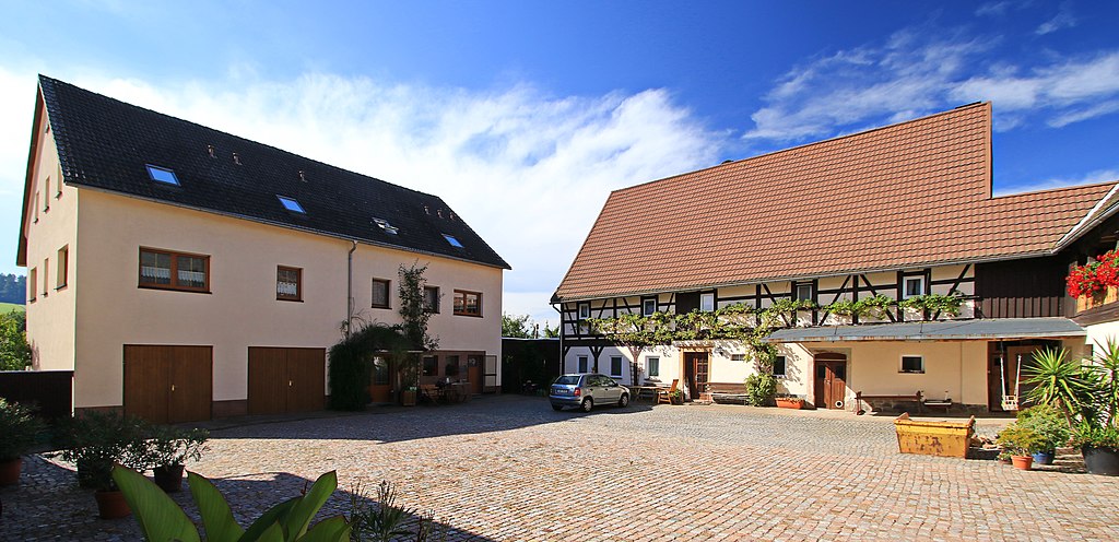
Deutsch: Fachwerkgebäude, für die Region seltenes Umgebindehaus, baugeschichtlich von Bedeutung.
Wohnstallhaus: Satteldach, Fachwerk im Obergeschoss, im Erdgeschoss hofseitig drei, giebelseitig zwei Fächer Umgebinde (geblattete Kopfbänder), Blockstube teilweise und Balkendecke erhalten, Fächer außen verputzt, Holztüre im Obergeschoss über der Haustüre, Werkstein-Türstock, Stalldecken um 1870 (Preußische Kappe), Hausbrunnen, Erstes Seitengebäude: Satteldach, vierbogige Oberlaube, geschweifte Köpfbänder, Doggen, Brüstungsbretter doggenartig ausgesägt, gezimmerte Durchfahrt (höhenversetzt) Scheune: Satteldach, Fachwerk im Obergeschoss,Zweites Seitengebäude: Satteldach, massiv (Streichung als Denkmal 2008). Sachsen Erzgebirgskreis. Hohndorf, Hauptstraße 10. |
| Date | |
| Source | Own work |
| Author | Kora27 |
| Camera location | | View this and other nearby images on: OpenStreetMap |
|---|
,_Seitengeb%C3%A4ude_(mit_Oberlaube)_und_Scheune_eines_Vierseithofes,_Hohndorf_2H1A3396WI.jpg¶ms=050.746945_N_0012.668515_E_globe:Earth_type:camera_heading:265.00&language=en)
Licensing
edit,_Seitengeb%C3%A4ude_(mit_Oberlaube)_und_Scheune_eines_Vierseithofes,_Hohndorf_2H1A3396WI.jpg&action=edit§ion=2)
I, the copyright holder of this work, hereby publish it under the following license:
This file is licensed under the Creative Commons Attribution-Share Alike 4.0 International license.
- You are free:
- to share – to copy, distribute and transmit the work
- to remix – to adapt the work
- Under the following conditions:
- attribution – You must give appropriate credit, provide a link to the license, and indicate if changes were made. You may do so in any reasonable manner, but not in any way that suggests the licensor endorses you or your use.
- share alike – If you remix, transform, or build upon the material, you must distribute your contributions under the same or compatible license as the original.

|
This image was uploaded as part of Wiki Loves Monuments 2021.
|
File history
Click on a date/time to view the file as it appeared at that time.
| Date/Time | Thumbnail | Dimensions | User | Comment | |
|---|---|---|---|---|---|
| current | 14:52, 23 September 2021 | | 5,468 × 2,648 (3.76 MB) | Kora27 (talk | contribs) | Uploaded own work with UploadWizard |
You cannot overwrite this file.
File usage on Commons
There are no pages that use this file.
,_Seitengebäude_(mit_Oberlaube)_und_Scheune_eines_Vierseithofes,_Hohndorf_2H1A3396WI.jpg&oldid=801662353)