File:World’s End from Rocky Neck (04aa7955-dde4-4b39-b9f5-84b032492a36).JPG

Size of this preview: 800 × 600 pixels. Other resolutions: 320 × 240 pixels | 640 × 480 pixels | 1,024 × 768 pixels | 1,280 × 960 pixels | 2,560 × 1,920 pixels | 3,799 × 2,849 pixels.
Original file (3,799 × 2,849 pixels, file size: 2.06 MB, MIME type: image/jpeg)
Captions
Captions
Add a one-line explanation of what this file represents

|
The categories of this image need checking. You can do so here.
|
.JPG&action=edit&withJS=MediaWiki:Catcheck.js)
Summary edit
.JPG&action=edit§ion=1)
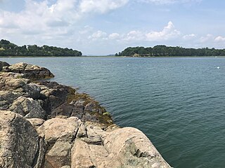
| English: World’s End from Rocky Neck | ||||
|---|---|---|---|---|
| Photographer |
English: NPS Photo |
|||
| Title |
English: World’s End from Rocky Neck |
|||
| Description |
English: A photo of the two drumlins of World’s End, which are connected by a low-laying tombolo. The foreground of the photo is Rocky Neck, another part of World’s End. It is very rocky, and there is some algae where the rocks meet the water. Saltwater fills the space between Rocky Neck and the main part of World’s End, and there are a few moorings. A photo of the two drumlins of World’s End, taken from a rocky outcropping in Rocky Neck. |
|||
| Depicted place |
English: Boston Harbor Islands National Recreation Area, Massachusetts |
|||
| Date | Taken on 8 August 2018 | |||
| Accession number | ||||
| Source |
English: NPGallery |
|||
| Permission (Reusing this file) |
|
|||
| NPS Unit Code | BOHA | |||
| Album(s) | English: BOHA Landscapes |
|||
File history
Click on a date/time to view the file as it appeared at that time.
| Date/Time | Thumbnail | Dimensions | User | Comment | |
|---|---|---|---|---|---|
| current | 18:19, 21 June 2023 | | 3,799 × 2,849 (2.06 MB) | BMacZeroBot (talk | contribs) | Batch upload (Commons:Batch uploading/NPGallery) |
You cannot overwrite this file.
File usage on Commons
The following page uses this file:
.JPG)
.JPG&oldid=794301204)