File:World empires and colonies around World War I.png
Size of this preview: 800 × 323 pixels. Other resolutions: 320 × 129 pixels | 640 × 258 pixels | 1,554 × 627 pixels.
Original file (1,554 × 627 pixels, file size: 63 KB, MIME type: image/png)
Captions
Captions
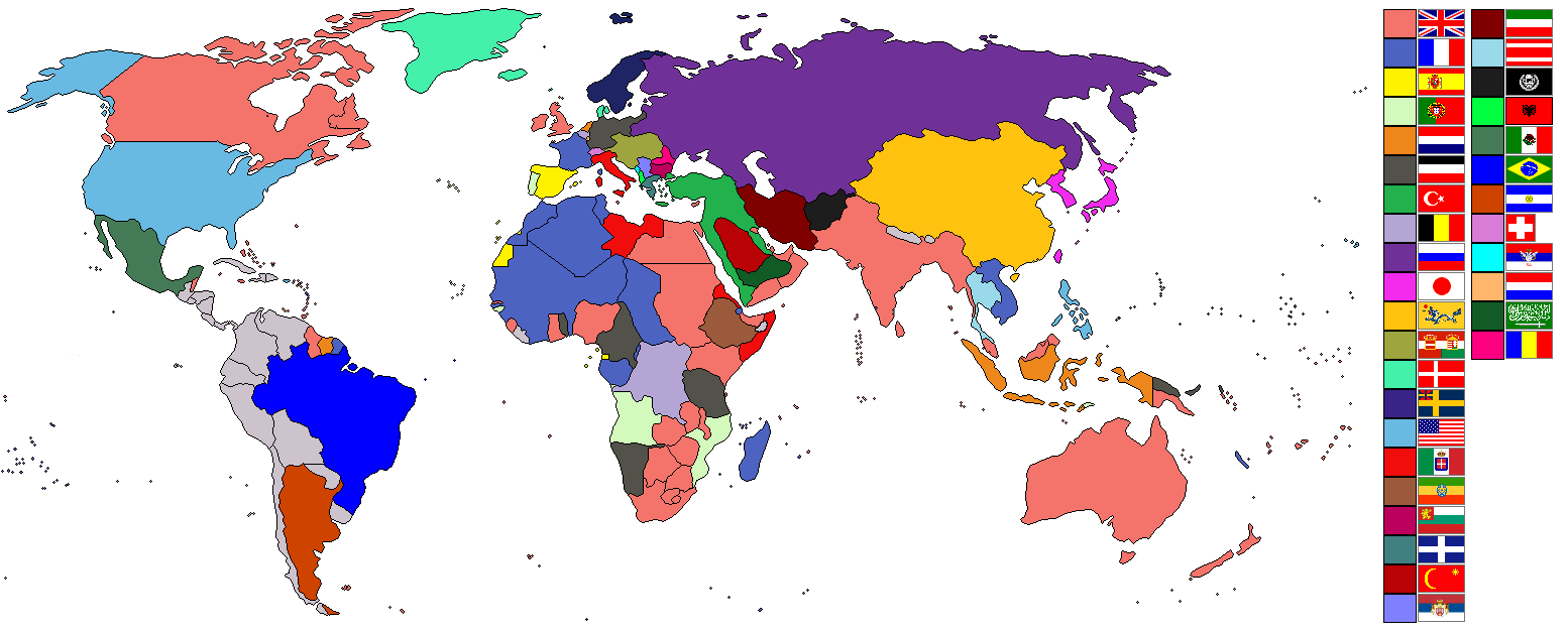
Map of the world in 1910
Summary
edit| Description |
English:
|
| Date | 2 August 2007 (original upload date) |
| Source | Taken from wikipedia map |
| Author | See below. |
| Other versions |
.png)

|
This historical map image could be re-created using vector graphics as an SVG file. This has several advantages; see Commons:Media for cleanup for more information. If an SVG form of this image is available, please upload it and afterwards replace this template with
{{vector version available|new image name}}.
It is recommended to name the SVG file “World empires and colonies around World War I.svg”—then the template Vector version available (or Vva) does not need the new image name parameter. |
Licensing
edit
Ishvara7 at English Wikipedia, the copyright holder of this work, hereby publishes it under the following licenses:

|
Permission is granted to copy, distribute and/or modify this document under the terms of the GNU Free Documentation License, Version 1.2 or any later version published by the Free Software Foundation; with no Invariant Sections, no Front-Cover Texts, and no Back-Cover Texts. A copy of the license is included in the section entitled GNU Free Documentation License. |
| This file is licensed under the Creative Commons Attribution-Share Alike 3.0 Unported license. | ||
| Attribution: Ishvara7 at English Wikipedia | ||
| ||
| This licensing tag was added to this file as part of the GFDL licensing update. |
This file is licensed under the Creative Commons Attribution-Share Alike 2.5 Generic, 2.0 Generic and 1.0 Generic license.
Attribution: Ishvara7 at English Wikipedia
- You are free:
- to share – to copy, distribute and transmit the work
- to remix – to adapt the work
- Under the following conditions:
- attribution – You must give appropriate credit, provide a link to the license, and indicate if changes were made. You may do so in any reasonable manner, but not in any way that suggests the licensor endorses you or your use.
- share alike – If you remix, transform, or build upon the material, you must distribute your contributions under the same or compatible license as the original.
You may select the license of your choice.
Original upload log
edit
Transferred from en.wikipedia to Commons by M0rphzone.
The original description page was here. All following user names refer to en.wikipedia.
- 2008-08-17 11:30 Scooter20 1554×627× (72711 bytes) + Added Romania
- 2007-09-09 06:32 Swedish fusilier 1554×627× (72758 bytes) *Original Author: [[Ishvara7]], edited by [[Swedish fusilier]] to correct the colouring of several southern Indian Ocean islands (eg. [[Kerguelen]]) which should be coloured as French possesions. *Taken from Wikipedia map *Nations involved with imperialis
- 2007-08-11 12:48 Taktser 1554×627× (72824 bytes)
- 2007-08-02 22:04 Ishvara7 1554×627× (73211 bytes) *Ishvara7 *Taken from wikipedia map *Dated around 1900 *Nations involved with imperialism, directly or indirectly, are colored. Meant to potray the world around the time of WWI. *In case anyone wonders, the red flag with the yellow crescent and star is th
The original description page was here. All following user names refer to en.wikipedia.
- 2007-08-02 21:15 Ishvara7 1554×627× (72719 bytes) *Ishvara7 *Taken from wikipedia map *Not all nations are colored. Only ones with the most importance related to colonialism, interaction with colonial powers, and WWI. *Map dates to the year 1900.
The original description page was here. All following user names refer to en.wikipedia.
- 2007-08-02 19:27 Ishvara7 1554×627× (72762 bytes) *Ishvara7 *New nations labled according to importance within world politics and WWI. *Taken from old colonialism wikipedia map
The original description page was here. All following user names refer to en.wikipedia.
- 2007-08-01 01:36 Ishvara7 1458×627× (63275 bytes) *Ishvara7 *Taken from old colonial map on wikipeia and outlined *Better images of flags and includes Ethiopian Empire *yes, it did take forever
File history
Click on a date/time to view the file as it appeared at that time.
| Date/Time | Thumbnail | Dimensions | User | Comment | |
|---|---|---|---|---|---|
| current | 09:09, 8 November 2021 | 1,554 × 627 (63 KB) | Randomastwritter (talk | contribs) | ogaden | |
| 02:48, 5 December 2012 | 1,554 × 627 (37 KB) | OjdvQ9fNJWl (talk | contribs) | Uploaded optimized image of first version here at Commons (latest on Wikipedia). File desc for prev version: *Ishvara7 *Taken from wikipedia map *Not all nations are colored. Only ones with the most importance related to colonialism, interaction with c... | ||
| 02:42, 5 December 2012 | 1,554 × 627 (71 KB) | OjdvQ9fNJWl (talk | contribs) | Old version from Wikipedia (File:Imperialism.png) dated 21:15, 2 August 2007 by Ishvara7. File desc for prev: *New nations labled according to importance within world politics and WWI. *Taken from old colonialism wikipedia map. | ||
| 02:29, 5 December 2012 | 1,554 × 627 (71 KB) | OjdvQ9fNJWl (talk | contribs) | Old version (File:Imperialism6.png) from Wikipedia by Ishvara7 at 19:27, 2 August 2007. File desc for prev upload: *Taken from old colonial map on wikipeia and outlined *Better images of flags and includes Ethiopian Empire *yes, it did take forever. Fi... | ||
| 02:25, 5 December 2012 |  | 1,458 × 627 (62 KB) | OjdvQ9fNJWl (talk | contribs) | Uploaded old image version from http://en.wikipedia.org/wiki/File:Imperialism_5.png uploaded by Ishvara7 at 01:36, 1 August 2007 (UTC) | |
| 02:03, 5 December 2012 | 1,554 × 627 (71 KB) | OjdvQ9fNJWl (talk | contribs) | {{Information |Description={{en|*Taken from wikipedia map. *Dated around 1900 (shows Italian - although the flag is not correct - North Africa post 1910 and Austro-Hungarian Empire circa WW1). British territories o... |
You cannot overwrite this file.
File usage on Commons
The following 2 pages use this file:
File usage on other wikis
The following other wikis use this file:
- Usage on ar.wikipedia.org
- Usage on bs.wikipedia.org
- Usage on ckb.wikipedia.org
- Usage on en.wikipedia.org
- Usage on fr.wikipedia.org
- Usage on km.wikipedia.org
- Usage on pnb.wikipedia.org
- Usage on sk.wikipedia.org
- Usage on ur.wikipedia.org