File:World moll.gif
No higher resolution available.
World_moll.gif (601 × 306 pixels, file size: 37 KB, MIME type: image/gif)
Captions
Captions
Add a one-line explanation of what this file represents
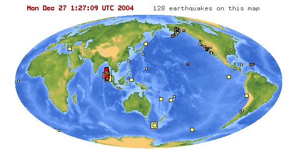
http://www.earthquake.usgs.gov/recenteqsww/index.html
Rectangles on the map indicate earthquake events, size indicating intensity. The color red indicates events with the past hour, deep yellow within the past 24 hours, yellow within the past week.
The largest rectangle near the island of Sumatra in the Indian Ocean indicates a 9.0 Richter Scale earthquake which occurred on 2004.12.26 00:58:50 UTC.
This image is in the public domain in the United States because it only contains materials that originally came from the United States Geological Survey, an agency of the United States Department of the Interior. For more information, see the official USGS copyright policy.
|
File history
Click on a date/time to view the file as it appeared at that time.
| Date/Time | Thumbnail | Dimensions | User | Comment | |
|---|---|---|---|---|---|
| current | 01:49, 27 December 2004 | | 601 × 306 (37 KB) | Jurema Oliveira (talk | contribs) |
You cannot overwrite this file.
File usage on Commons
The following page uses this file: