File:Worringen 1288.svg

Original file (SVG file, nominally 900 × 1,101 pixels, file size: 41 KB)
Captions
Captions
Summary edit
| Description |
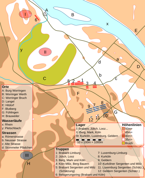
Map of the Worringen battlefield. Positions around 11AM, June 5 1288. Brabantians coloured red, Cologne-Luxembourg blue. Karte des Worringer Schlachtfeld. Lage ca. 11 Uhr morgens am 5. Juni 1288. Brabanter rot gefärbt, Kurköln-Luxemburger blau. |
| Date | 18 January 2007 (original upload date) |
| Source | No machine-readable source provided. Own work assumed (based on copyright claims). |
| Author | No machine-readable author provided. Caranorn assumed (based on copyright claims). |
Sources edit
- Topographische Karte 1:25,000: #4907 Leverkusen, Landesvermessungsamt Nordhrhein-Westfalen.
- Die Schlacht von Worringen 1288: Kriegsführung im Mittelalter, Ulrich Lehnart, Afra Verlag.
- Der Name der Freiheit 1288-1988, Herausgeber Werner Schäfke, Handbuch zur Ausstellung der Stadt Köln zur 700-Jahr-Erinnerung, 29.1.-1.5.1988 in der Josef-Haubrich-Kunsthalle Köln, 677 Seiten. Karten dort: Seite 241-245.
Notes edit
There are some discrepancies between the topographical map and Lehnart's map between Fühlingen and the crossroads Neusser- and Alte-Strasse. I decided to follow the topographical map for this as Lehnart did not explain the differences. Lehnart's drawings also show the Cologne-Luxembourgish forces on a wider front then they could have deployed in (he gives ~1000, 800 and 1000 cavalry each in 3x2 ranks), I followed his text descriptions and common logic to draw these units onto the map.
Es bestehen einige Ungereihmtheiten zwischen der topographischen Karte und Lehnarts Karte im Raum zwischen Fühlingen und der Kreuzung Neusser- und Alte-Strasse. Ich habe mich dabei an der topographischen Karte orientiert da Lehnart diese Abweichungen nicht erklärt. Lehnarts Zeichnung zeigt auch die Kurkölner-Luxemburger Truppen auf einer breiteren Front als möglich (er nennt ~1000, 800 und 1000 Kavallerie in je 3x2 Rängen), hier habe ich mich an die Text Beschreibung und allgemeine Logik gehalten um die Einheiten einzuzeichnen.
Kommentar von „Krum44“: Die "offiziellen Karten" zur Aufstellung der Truppen aus dem Rijksarchief in Limburg sind abgebildet in Buch "Der Name der Freiheit 1288-1988" herausgegeben von Werner Schäfke, siehe oben SOURCES, und zwar auf Seite 243, Autor P.A.W. Dingemans. Letztere Karten werden allgemein als plausibel anerkannt. Die hier gezeigte Karte weicht von jenen "offiziellen" ab, was problematisch ist. Der angreifende Erzbischof wollte zu seiner Worringer Burg am Rhein. Er konnte nicht durch das unwegsame Gelände des Worringer Bruchs, sondern musste zwischen dem nordöstlichen Ausläufer des Bruchs und dem Rhein durchmarschieren. Demzufolge verorten die anderen Autoren das Brabanter Heer ganz im Zwickel zwischen der alten Römerstrasse und der Neusser Landstrasse. Der Autor des (ansonsten gut recherchierten) Artikels verortet die Truppe zu weit nach Westen, westlich statt östlich der Neusser Landstrasse, nahe des sog. Blutbergs. Auch nach Auskunft des Worringer Heimatvereins ist jedoch niemals irgendetwas beim Blutberg gefunden worden, welches auf die damals größte Ritterschlacht des Mittelalters an dieser Stelle hingedeutet hätte.
Licensing edit

|
Permission is granted to copy, distribute and/or modify this document under the terms of the GNU Free Documentation License, Version 1.2 or any later version published by the Free Software Foundation; with no Invariant Sections, no Front-Cover Texts, and no Back-Cover Texts. A copy of the license is included in the section entitled GNU Free Documentation License. |
| This file is licensed under the Creative Commons Attribution-Share Alike 3.0 Unported license. | ||
| ||
| This licensing tag was added to this file as part of the GFDL licensing update. |
- You are free:
- to share – to copy, distribute and transmit the work
- to remix – to adapt the work
- Under the following conditions:
- attribution – You must give appropriate credit, provide a link to the license, and indicate if changes were made. You may do so in any reasonable manner, but not in any way that suggests the licensor endorses you or your use.
- share alike – If you remix, transform, or build upon the material, you must distribute your contributions under the same or compatible license as the original.
File history
Click on a date/time to view the file as it appeared at that time.
| Date/Time | Thumbnail | Dimensions | User | Comment | |
|---|---|---|---|---|---|
| current | 22:12, 6 August 2023 | | 900 × 1,101 (41 KB) | Antonsusi (talk | contribs) | valid code |
| 17:53, 21 January 2007 |  | 598 × 733 (62 KB) | Caranorn (talk | contribs) | Final version of the map, all data should now be included. | |
| 17:43, 20 January 2007 |  | 598 × 733 (56 KB) | Caranorn (talk | contribs) | One more try, saved in inkscape this time. | |
| 17:26, 20 January 2007 |  | 598 × 733 (50 KB) | Caranorn (talk | contribs) | I think that should remove the last bitmap graphics in the file. | |
| 17:10, 20 January 2007 |  | 598 × 733 (45 KB) | Caranorn (talk | contribs) | Oops, I indeed saved the large bitmap image I drew on in the file, no wonder it was so large and didn't display well. | |
| 23:11, 19 January 2007 |  | 598 × 733 (1.7 MB) | Caranorn (talk | contribs) | Third version, almost complete now. | |
| 17:54, 19 January 2007 |  | 598 × 733 (1.87 MB) | Caranorn (talk | contribs) | Updated version. All terrain features included, labeling of major features. Missing, terrain legend, units at start of battle. | |
| 23:53, 18 January 2007 |  | 598 × 733 (1.85 MB) | Caranorn (talk | contribs) | Test for an svg map of the Battle of Worringen 1288, only some elevations, river, brook, swamp and castle on the experimental map. Final map under same name will include additional elevation levels, roads and unit positions at the start of the battle. |
You cannot overwrite this file.
File usage on Commons
The following 4 pages use this file:
File usage on other wikis
The following other wikis use this file:
- Usage on cs.wikipedia.org
- Usage on de.wikipedia.org
- Usage on en.wikipedia.org
- Usage on fr.wikipedia.org
- Usage on hu.wikipedia.org
- Usage on lb.wikipedia.org
- Usage on ro.wikipedia.org