File:Worsley junction - geograph.org.uk - 1500528.jpg
No higher resolution available.
Worsley_junction_-_geograph.org.uk_-_1500528.jpg (640 × 479 pixels, file size: 126 KB, MIME type: image/jpeg)
Captions
Captions
Add a one-line explanation of what this file represents
Summary edit
| Description |
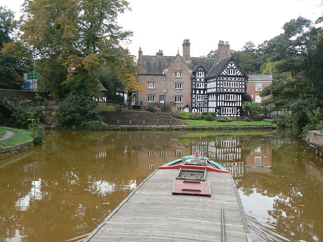
English: Worsley junction To the right is the branch up into the Delph for the mine workings which were the main reason for the building of the Bridgewater Canal. The line to Leigh continues to the left. The red colour of the water is due to the minerals leaching out of the old mine workings. Straight ahead is Worsley Packet House.
The helmsman of the narrowboat has to make a hard left turn and hope that there is nothing coming the other way through the bridge. |
| Date | |
| Source | From geograph.org.uk |
| Author | Alan Murray-Rust |
| Attribution (required by the license) | Alan Murray-Rust / Worsley junction / |
| Camera location | | View this and other nearby images on: OpenStreetMap |
|---|
_heading:315.00&language=en)
| Object location | | View this and other nearby images on: OpenStreetMap |
|---|
_heading:315.00&language=en)
Licensing edit

|
This image was taken from the Geograph project collection. See this photograph's page on the Geograph website for the photographer's contact details. The copyright on this image is owned by Alan Murray-Rust and is licensed for reuse under the Creative Commons Attribution-ShareAlike 2.0 license.
|
This file is licensed under the Creative Commons Attribution-Share Alike 2.0 Generic license.
Attribution: Alan Murray-Rust
- You are free:
- to share – to copy, distribute and transmit the work
- to remix – to adapt the work
- Under the following conditions:
- attribution – You must give appropriate credit, provide a link to the license, and indicate if changes were made. You may do so in any reasonable manner, but not in any way that suggests the licensor endorses you or your use.
- share alike – If you remix, transform, or build upon the material, you must distribute your contributions under the same or compatible license as the original.
File history
Click on a date/time to view the file as it appeared at that time.
| Date/Time | Thumbnail | Dimensions | User | Comment | |
|---|---|---|---|---|---|
| current | 22:28, 2 March 2011 | | 640 × 479 (126 KB) | GeographBot (talk | contribs) | == {{int:filedesc}} == {{Information |description={{en|1=Worsley junction To the right is the branch up into the Delph for the mine workings which were the main reason for the building of the Bridgewater Canal. The line to Leigh continues to the left. The |
You cannot overwrite this file.
File usage on Commons
There are no pages that use this file.