File:Worthing UK local election 2010 map.svg

Size of this PNG preview of this SVG file: 773 × 599 pixels. Other resolutions: 310 × 240 pixels | 619 × 480 pixels | 991 × 768 pixels | 1,280 × 993 pixels | 2,560 × 1,985 pixels | 1,425 × 1,105 pixels.
Original file (SVG file, nominally 1,425 × 1,105 pixels, file size: 139 KB)
Captions
Captions
Add a one-line explanation of what this file represents
| Description |
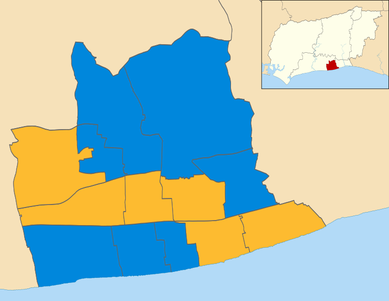
Map of Worthing, West Sussex, UK showing the results of the 2010 local election. Colours: Conservative
Liberal Democrat |
| Date | (UTC) |
| Source | |
| Author |
|
.svg)
I, the copyright holder of this work, hereby publish it under the following license:
This file is licensed under the Creative Commons Attribution-Share Alike 3.0 Unported license.
- You are free:
- to share – to copy, distribute and transmit the work
- to remix – to adapt the work
- Under the following conditions:
- attribution – You must give appropriate credit, provide a link to the license, and indicate if changes were made. You may do so in any reasonable manner, but not in any way that suggests the licensor endorses you or your use.
- share alike – If you remix, transform, or build upon the material, you must distribute your contributions under the same or compatible license as the original.
Original upload log
edit
This image is a derivative work of the following images:
- File:Worthing_UK_ward_map_2010_(blank).svg licensed with Cc-by-sa-3.0
- 2011-04-25T00:19:02Z Nilfanion 1425x1105 (142615 Bytes) {{Information |Description=Map of Worthing, West Sussex, UK with electoral wards shown. Equirectangular map projection on WGS 84 datum, with N/S stretched 155% Geographic limits: *West: 0.45W *East: 0.31W *North: 50.87N *So
Uploaded with derivativeFX
File history
Click on a date/time to view the file as it appeared at that time.
| Date/Time | Thumbnail | Dimensions | User | Comment | |
|---|---|---|---|---|---|
| current | 12:42, 27 August 2011 | | 1,425 × 1,105 (139 KB) | Davewild (talk | contribs) | {{Information |Description=Map of Worthing, West Sussex, UK showing the results of the 2010 local election. Colours: {{legend|#0087dc|Conservative}} {{legend|#fdbb30|Liberal Democrat}} |Source=*File:Worthing_UK_ward_map_2010_(blank).svg |Date=2011- |
You cannot overwrite this file.
File usage on Commons
There are no pages that use this file.
File usage on other wikis
The following other wikis use this file:
- Usage on en.wikipedia.org
- Usage on www.wikidata.org