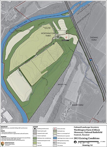
File:Worthington Farm. The National Park Service purchased 280 acres of the Worthington property in 1982. Although the farm has lost (df136cb5-edbe-6a7a-1215-8a813ae07834).jpg

Size of this preview: 439 × 600 pixels. Other resolutions: 176 × 240 pixels | 351 × 480 pixels | 659 × 900 pixels.
Original file (659 × 900 pixels, file size: 201 KB, MIME type: image/jpeg)
Captions
Captions
Add a one-line explanation of what this file represents

|
The categories of this image need checking. You can do so here.
|
.jpg&action=edit&withJS=MediaWiki:Catcheck.js)
Summary
edit.jpg&action=edit§ion=1)
| English: Landscape Site Plan. | ||||
|---|---|---|---|---|
| Photographer |
English: NPS |
|||
| Title |
English: Landscape Site Plan. |
|||
| Publisher |
English: U.S. National Park Service |
|||
| Description |
English: A site plan shows the landscape character types and major features of the farm. Worthington Farm. The National Park Service purchased 280 acres of the Worthington property in 1982. Although the farm has lost some of the features that existed during the Civil War battle, the landscape retains its historic rural agricultural character through surviving circulation systems, field and forest patterns, and the main house.
|
|||
| Depicted place |
English: 39.36153, -77.40297; Monocacy National Battlefield, Frederick County, Maryland; Latitude: 39.3577003479004, Longitude: -77.4024963378906 |
|||
| Date | Taken on 26 September 2013 | |||
| Accession number | ||||
| Source |
English: NPGallery |
|||
| Permission (Reusing this file) |
|
|||
| NPS Unit Code | MONO | |||
| Album(s) | English: Worthington Farm |
|||
File history
Click on a date/time to view the file as it appeared at that time.
| Date/Time | Thumbnail | Dimensions | User | Comment | |
|---|---|---|---|---|---|
| current | 18:25, 15 May 2024 | | 659 × 900 (201 KB) | BMacZeroBot (talk | contribs) | Batch upload (Commons:Batch uploading/NPGallery) |
You cannot overwrite this file.
File usage on Commons
The following page uses this file:
.jpg)
.jpg&oldid=888439416)