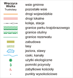
File:Wręczyca Wielka.png

Size of this preview: 786 × 599 pixels. Other resolutions: 315 × 240 pixels | 630 × 480 pixels | 1,007 × 768 pixels | 1,280 × 976 pixels | 2,063 × 1,573 pixels.
Original file (2,063 × 1,573 pixels, file size: 1.42 MB, MIME type: image/png)
File information
Structured data
Captions
Captions
Add a one-line explanation of what this file represents
Summary edit
| DescriptionWręczyca Wielka.png |
English: Map of Wręczyca Wielka commune
|
| Date | |
| Source |
Own work, na podstawie:
|
| Author | Aotearoa |
Licensing edit
I, the copyright holder of this work, hereby publish it under the following licenses:

|
Permission is granted to copy, distribute and/or modify this document under the terms of the GNU Free Documentation License, Version 1.2 or any later version published by the Free Software Foundation; with no Invariant Sections, no Front-Cover Texts, and no Back-Cover Texts. A copy of the license is included in the section entitled GNU Free Documentation License.http://www.gnu.org/copyleft/fdl.htmlGFDLGNU Free Documentation Licensetruetrue |
| This file is licensed under the Creative Commons Attribution-Share Alike 3.0 Unported license. | ||
| ||
| This licensing tag was added to this file as part of the GFDL licensing update.http://creativecommons.org/licenses/by-sa/3.0/CC BY-SA 3.0Creative Commons Attribution-Share Alike 3.0truetrue |
You may select the license of your choice.
|
File history
Click on a date/time to view the file as it appeared at that time.
| Date/Time | Thumbnail | Dimensions | User | Comment | |
|---|---|---|---|---|---|
| current | 13:42, 8 May 2011 |  | 2,063 × 1,573 (1.42 MB) | Aotearoa (talk | contribs) | Zmiana nazwy rzeki z Kopka na Panówka |
| 10:51, 19 April 2009 |  | 2,063 × 1,573 (1.42 MB) | Aotearoa (talk | contribs) | Dodanie rzeźby terenu i stacji kolejowych | |
| 20:12, 18 April 2009 |  | 2,063 × 1,573 (695 KB) | Aotearoa (talk | contribs) | Dodanie obszarów chronionych | |
| 19:02, 15 April 2009 |  | 2,063 × 1,573 (606 KB) | Aotearoa (talk | contribs) | Poprawa nazw | |
| 09:51, 15 April 2009 |  | 2,063 × 1,573 (700 KB) | Aotearoa (talk | contribs) | {{Information |Description={{en|1=Map of Wręczyca Wielka commune}} {{pl|1=Mapa gminy Wręczyca Wielka}} |Source=Praca własna osoby przesyłającej (own work by uploader) |Author=Aotearoa |Date=15.05.2005 |Permission= |other_versions= } |
You cannot overwrite this file.
File usage on Commons
There are no pages that use this file.
File usage on other wikis
The following other wikis use this file:
- Usage on pl.wikipedia.org
- Wręczyca Wielka (gmina)
- Truskolasy (województwo śląskie)
- Kościół św. Mikołaja w Truskolasach
- Węglowice
- Bieżeń
- Bór Zapilski
- Hutka (województwo śląskie)
- Kuleje (wieś w województwie śląskim)
- Kalej
- Piła Druga
- Piła Pierwsza
- Puszczew
- Szarlejka
- Wręczyca Mała
- Wręczyca Wielka
- Wydra (województwo śląskie)
- Grodzisko (województwo śląskie)
- Borowe (województwo śląskie)
- Brzezinki (gmina Wręczyca Wielka)
- Czarna Wieś (województwo śląskie)
- Długi Kąt (województwo śląskie)
- Golce (województwo śląskie)
- Jezioro (województwo śląskie)
- Nowiny (województwo śląskie)
- Pierzchno (wieś w województwie śląskim)
- Zamłynie (województwo śląskie)
- Klepaczka (powiat kłobucki)
- Wikipedysta:Aotearoa/brudnopis
- RTCN Wręczyca
- Nowa Szarlejka
- Kuleje (przystanek kolejowy)
- Wikipedia:Ilustracje na Medal/rysunki i animacje
- Wikipedysta:Aotearoa/mapy
- Wręczyca (stacja kolejowa)
- Rezerwat przyrody Zamczysko (województwo śląskie)
- Wikipedia:Propozycje do Ilustracji na Medal/Wręczyca Wielka.png
- Dyskusja pliku:Wręczyca Wielka.png
- Parafia św. Józefa Oblubieńca Najświętszej Maryi Panny we Wręczycy Wielkiej
- Szablon:Ilustracja na medal/2011-10-31
- Kościół św. Jacka w Borze Zapilskim
- Szablon:Ilustracja na medal/2013-07-04
- Gajówka Bieżeń
- Gajówka Kalej
- Ług (województwo śląskie)
- Podgaj (powiat kłobucki)
- Wręczyca (województwo śląskie)
- Kuleje (osada leśna w województwie śląskim)
- Pierzchno (osada leśna w województwie śląskim)
- Szablon:Ilustracja na medal/2014-07-17
- Wikipedysta:The Polish/Nieużywane szablony/Ilustracja na medal/1-500
View more global usage of this file.
