File:Wuhan Metro bilingual map.png

Size of this preview: 800 × 586 pixels. Other resolutions: 320 × 234 pixels | 640 × 468 pixels | 1,024 × 750 pixels | 1,280 × 937 pixels | 2,560 × 1,874 pixels | 3,018 × 2,209 pixels.
Original file (3,018 × 2,209 pixels, file size: 1.11 MB, MIME type: image/png)
Captions
Captions
Add a one-line explanation of what this file represents
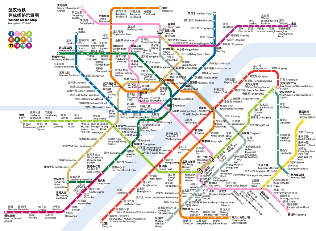
History of Wuhan Metro system edit
- 2004-07-28, Line 1 (Zongguan to Huangpu Road) opened.
- 2006-04-08, Taipingyang station (Line 1) opened.
- 2010-07-29, Line 1 extended west to Dongwu Blvd, east to Dijiao.
- 2012-12-28, Line 2 opened, Jinyintan to Optics Valley Square.
- 2013-12-28, Line 4 opened, Wuhan Railway Station to Wuchang Railway Station.
- 2014-05-28, Line 1 extended east to Hankou North.
- 2014-09-17, Zhuyehai station on Line 1 opened.
- 2014-12-28, Line 4 extended west to Huangjinkou.
- 2015-12-28, Line 3 opened, Hongtu Blvd to Zhuanyang Blvd.
- 2016-12-28, Line 6 opened, Jinyinhu Park to Dongfeng Motor Corproation.
- 2016-12-28, Line 2 extended north to Tianhe Airport.
- 2017-12-26, Line 1 extended west to Jinghe.
- 2017-12-26, Line 8 opened, Jintan Road to Liyuan.
- 2017-12-26, Yangluo Line opened, Houhu Boulevard to Jintai.
- 2018-10-01, Line 7 opened, Garden Expo North to Yezhihu
- 2018-10-01, Line 11 opened, Optics Valley Railway Station to Zuoling.
- 2018-12-28, Line 7 extended south to Qinglongshan Ditiexiaozhen.
- 2019-02-19, Line 2 extended south to Fozuling.
- 2019-09-25, Line 4 extended west to Bailin (Bolin).
- 2019-11-06, Line 8 opened a section between Yezhihu and Military Athletes' Village.
- 2021-01-02, Line 8 opened a section between Yezhihu and Liyuan.
- 2021-01-02, Line 11 extended east to Gediannan Railway Station.
- 2021-12-26, Line 5 opened, Hubei University of Chinese Medicine to East Square of Wuhan Railway Station.
- 2021-12-26, Line 16 opened, Zhoujiahe to South International Expo Center.
- 2021-12-26, Line 6 extended west to Xincheng 11th Road.
- 2022-12-30, Line 7 extended north to Hengdian.
- 2022-12-30, Line 16 extended south to Hannan General Airport.
- 2023-12-01, Line 5 extended south to Hongxia.
- 2023-12-30, Line 19 opened, West Square of Wuhan Railway Station to Xinyuexi Park.
Summary edit
| Description |
English: Wuhan Metro bilingual Map |
| Date | |
| Source | Own work |
| Author | Howchou |
Licensing edit
I, the copyright holder of this work, hereby publish it under the following license:
This file is licensed under the Creative Commons Attribution-Share Alike 3.0 Unported license.
- You are free:
- to share – to copy, distribute and transmit the work
- to remix – to adapt the work
- Under the following conditions:
- attribution – You must give appropriate credit, provide a link to the license, and indicate if changes were made. You may do so in any reasonable manner, but not in any way that suggests the licensor endorses you or your use.
- share alike – If you remix, transform, or build upon the material, you must distribute your contributions under the same or compatible license as the original.
cum
File history
Click on a date/time to view the file as it appeared at that time.
| Date/Time | Thumbnail | Dimensions | User | Comment | |
|---|---|---|---|---|---|
| current | 06:53, 6 January 2024 | | 3,018 × 2,209 (1.11 MB) | Howchou (talk | contribs) | Line 5 extended and Line 19 opened |
| 18:46, 20 January 2023 |  | 2,983 × 2,209 (1.09 MB) | Howchou (talk | contribs) | fix xinrong | |
| 18:02, 20 January 2023 |  | 2,983 × 2,209 (1.09 MB) | Howchou (talk | contribs) | Line 7 and Line 16 extended | |
| 04:33, 28 December 2021 |  | 2,815 × 2,165 (1.08 MB) | Howchou (talk | contribs) | add missing jiangcheng blvd | |
| 17:22, 27 December 2021 |  | 2,815 × 2,165 (1.08 MB) | Howchou (talk | contribs) | 3 new lines opened | |
| 15:56, 3 January 2021 |  | 2,786 × 2,172 (1.08 MB) | Painjet (talk | contribs) | 修正武汉商务区站笔误 | |
| 08:07, 2 January 2021 |  | 2,786 × 2,172 (1.01 MB) | Howchou (talk | contribs) | update new sections | |
| 04:16, 22 June 2020 |  | 2,786 × 2,172 (1,007 KB) | Painjet (talk | contribs) | fix | |
| 17:58, 24 May 2020 |  | 2,786 × 2,172 (1,010 KB) | Howchou (talk | contribs) | small fix | |
| 09:31, 23 May 2020 |  | 2,786 × 2,172 (1,012 KB) | Howchou (talk | contribs) | update line 4 and line 8 |
You cannot overwrite this file.
File usage on Commons
The following 31 pages use this file:
- Wuhan Metro
- User:Chumwa/OgreBot/Potential transport maps/2016 December 11-20
- User:Chumwa/OgreBot/Potential transport maps/2017 December 21-31
- User:Chumwa/OgreBot/Potential transport maps/2018 October 11-20
- User:Chumwa/OgreBot/Potential transport maps/2019 February 10-18
- User:Chumwa/OgreBot/Public transport information/2015 December 11-20
- User:Chumwa/OgreBot/Public transport information/2016 December 11-20
- User:Chumwa/OgreBot/Public transport information/2017 December 21-31
- User:Chumwa/OgreBot/Public transport information/2018 October 11-20
- User:Chumwa/OgreBot/Public transport information/2019 February 10-18
- User:Chumwa/OgreBot/Public transport information/2020 June 21-30
- User:Chumwa/OgreBot/Public transport information/2020 May 21-31
- User:Chumwa/OgreBot/Public transport information/2021 December 21-31
- User:Chumwa/OgreBot/Public transport information/2021 January 1-10
- User:Chumwa/OgreBot/Public transport information/2023 January 11-20
- User:Chumwa/OgreBot/Public transport information/2024 January 1-10
- User:Chumwa/OgreBot/Transport Maps/2015 December 11-20
- User:Chumwa/OgreBot/Transport Maps/2016 December 11-20
- User:Chumwa/OgreBot/Transport Maps/2017 December 21-31
- User:Chumwa/OgreBot/Transport Maps/2018 October 11-20
- User:Chumwa/OgreBot/Transport Maps/2019 February 10-18
- User:Chumwa/OgreBot/Transport Maps/2020 June 21-30
- User:Chumwa/OgreBot/Transport Maps/2020 May 21-31
- User:Chumwa/OgreBot/Transport Maps/2021 December 21-31
- User:Chumwa/OgreBot/Transport Maps/2021 January 1-10
- User:Chumwa/OgreBot/Transport Maps/2023 January 11-20
- User:Chumwa/OgreBot/Transport Maps/2024 January 1-10
- User:Chumwa/OgreBot/Travel and communication maps/2016 December 11-20
- User:Chumwa/OgreBot/Travel and communication maps/2017 December 21-31
- User:Chumwa/OgreBot/Travel and communication maps/2018 October 11-20
- User:Chumwa/OgreBot/Travel and communication maps/2019 February 10-18
File usage on other wikis
The following other wikis use this file:
- Usage on ca.wikipedia.org
- Usage on de.wikivoyage.org
- Usage on en.wikipedia.org
- Usage on en.wikivoyage.org
- Usage on eo.wikipedia.org
- Usage on es.wikipedia.org
- Usage on id.wikipedia.org
- Usage on it.wikivoyage.org
- Usage on ja.wikipedia.org
- Usage on ko.wikipedia.org
- Usage on nl.wikipedia.org
- Usage on oc.wikipedia.org
- Usage on pl.wikivoyage.org
- Usage on ru.wikipedia.org
- Usage on th.wikipedia.org
- Usage on zh.wikipedia.org
- Usage on zh.wikivoyage.org